25th Annual Black Diamond Fall Fundraising Party
Thursday, September 13; 6:00-10:00 PM; Black Diamond Parking Lot
25th Annual Black Diamond Fall Fundraising Party
Thursday, September 13; 6:00-10:00 PM; Black Diamond Parking Lot
| Advisory: Uintas Area Mountains | Issued by Craig Gordon for Tuesday - February 7, 2017 - 3:12am |
|---|

|
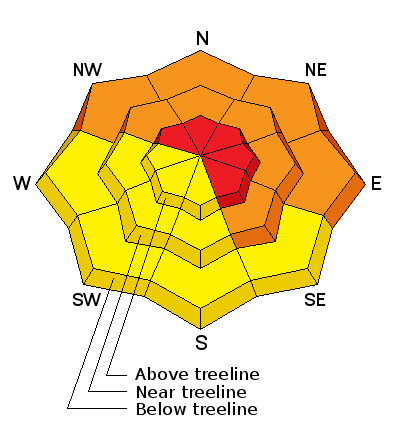
bottom line As the storm materializes, dangerous avalanche conditions will develop... any avalanche that breaks to weaker snow, now buried a couple feet deep in the snowpack will get out of hand quickly. At and above treeline, a HIGH avalanche danger exists. Both human triggered and natural avalanches are VERY LIKELY on steep, leeward slopes facing the north half of the compass. CONSIDERABLE avalanche danger is found on steep, shady slopes at mid and lower elevations and human triggered avalanches are LIKELY. Human triggered wet avalanches are possible at lower elevations and a MODERATE avalanche danger is found on steep, water laden slopes.
|
 |
avalanche warning THE FOREST SERVICE UTAH AVALANCHE CENTER IN SALT LAKE CITY HAS ISSUED A BACKCOUNTRY AVALANCHE WARNING. * TIMING...FROM NOON TODAY UNTIL 6AM MST WEDNESDAY * AFFECTED AREA...FOR THE MOUNTAINS OF NORTHERN UTAH AND SE IDAHO INCLUDING THE WASATCH RANGE...WESTERN UINTA RANGE...BEAR RIVER RANGE...WELLSVILLE RANGE. * AVALANCHE DANGER...THE AVALANCHE DANGER FOR THE WARNING AREA IS HIGH. * REASON/IMPACTS...RAIN, HEAVY SNOWFALL, AND STRONG WINDS ARE CREATING UNSTABLE SNOW AT ALL ELEVATIONS. VERY DANGEROUS AVALANCHE CONDITIONS EXIST, NATURAL AVALANCHES ARE LIKELY. STAY OFF OF AND OUT FROM UNDER SLOPES STEEPER THAN 30 DEGREES. AVOID AVALANCHE RUN OUT ZONES. THIS WARNING DOES NOT APPLY TO SKI AREAS WHERE AVALANCHE HAZARD REDUCTION MEASURES ARE PERFORMED. |
 |
special announcement We still have a few slots open for this weeks Sled Specific Avy Awareness and Riding Skills Class. More details here. Do you buy groceries at Smiths? When you register your Smith’s rewards card with their Community Rewards program, they will donate to the Utah Avalanche Center whenever you make a purchase. It's easy, only takes a minute, and doesn't cost you anything. Details here. |
 |
current conditions A firehose of moisture delivered 5" of dense, heavy snow overnight. Temperatures are in the 20's and 30's and southwest winds are cranking in the 40's and 50's along the high ridges. Real time wind, snow, and temperatures for the Uinta's are found here Snowpack observations and trip reports are found here. |
 |
recent activity No significant avalanche activity observed or reported from yesterday. A full list of Uinta avalanche activity is found here. |
| type | aspect/elevation | characteristics |
|---|

|
|
LIKELIHOOD
 LIKELY
UNLIKELY
SIZE
 LARGE
SMALL
TREND
 INCREASING DANGER
SAME
DECREASING DANGER
|
|
description
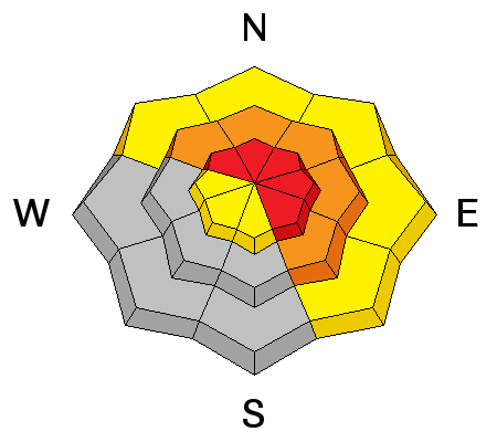
Southwest winds are cranking, creating dense cohesive slabs. Todays fresh drifts will react to our additional weight and break deeper than you'd expect. Found mostly on the leeward side of upper elevation ridges and around terrain features like chutes and gullies, I bet strong winds are getting into mid elevation terrain as well. Today you need to be on your "A Game" and gather information as you travel. Stomp on a few road cuts similar in aspect, elevation, and slope angle to what you wanna ride and see how they're reacting. |
| type | aspect/elevation | characteristics |
|---|

|
|
LIKELIHOOD
 LIKELY
UNLIKELY
SIZE
 LARGE
SMALL
TREND
INCREASING DANGER
SAME
DECREASING DANGER
|
|
description
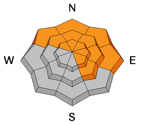
Surface hoar and near surface facets- Mark posted an informative viddy explaining the setup and his recent decision not to ride a slope because of the snow structure his crew found. On the north half of the compass, a fragile layer of surface hoar and weak, sugary, near surface facets were preserved and buried prior to the big January storm cycle. Suspect terrain includes mid and low elevation creek bottoms and terrain features where cold air pools. These weak layers are now buried several feet beneath the snow surface. Heavy snow, rising temperatures, and strong winds will bring these dormant layers back to life. It's a deceptive setup for sure, but it doesn't have to be a roll of the dice. With a little homework, by digging around you can easily identify slopes that have a suspect snowpack and simply avoid them. |
| type | aspect/elevation | characteristics |
|---|

|
|
LIKELIHOOD
 LIKELY
UNLIKELY
SIZE
 LARGE
SMALL
TREND
 INCREASING DANGER
SAME
DECREASING DANGER
|
|
description
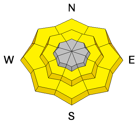
Rain, mixed with snow at lower elevations will create damp, manky conditions. Today, avoid any steep slope that feels unsupportable or punchy and steer clear of terrain traps like gullies and road cuts where wet, heavy, cement-like debris can stack up very deeply. |
 |
weather A great viddy by the NWS explaining our storm is found here. The storm arrives this morning and westerly winds nuke into the 60's and 70's along the high ridges. Periods of heavy snow start kicking in this morning and we can expect a foot of snow by tomorrow morning. It'll be warm with highs in the mid 30's and lower elevations may mix with or change to rain especially after midday. Scattered snow showers for Wednesday and then it becomes very warm Thursday with temperatures rising into the low 40's. Another storm system brings significant snow, water, and winds Friday through Saturday. |
| general announcements Remember your information can save lives. If you see anything we should know about, please participate in the creation of our own community avalanche advisory by submitting snow and avalanche conditions. You can call me directly at 801-231-2170, email [email protected] The information in this advisory is from the US Forest Service which is solely responsible for its content. This advisory describes general avalanche conditions and local variations always occur. The information in this advisory expires 24 hours after the date and time posted, but will be updated by 7:00 AM on Wednesday February 8th. |


