25th Annual Black Diamond Fall Fundraising Party
Thursday, September 13; 6:00-10:00 PM; Black Diamond Parking Lot
25th Annual Black Diamond Fall Fundraising Party
Thursday, September 13; 6:00-10:00 PM; Black Diamond Parking Lot
| Advisory: Uintas Area Mountains | Issued by Craig Gordon for Monday - January 23, 2017 - 3:39am |
|---|

|
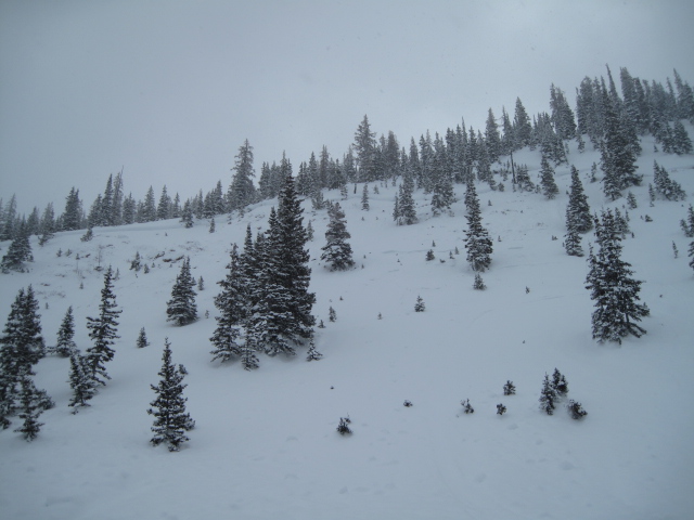
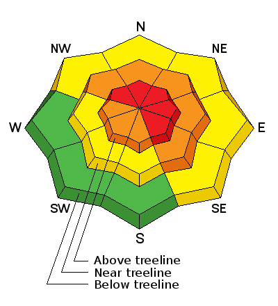
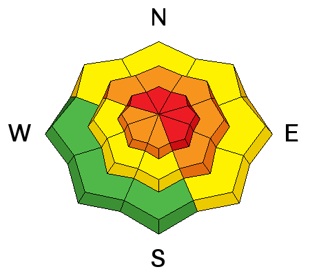
bottom line In the wind zone, at and above treeline, the avalanche danger is HIGH. Both human triggered and natural avalanches are VERY LIKELY on steep, wind drifted slopes, especially those on the leeward side of upper elevation ridges and particularly those with an easterly component to their aspect. Remember- any avalanche that breaks to weaker snow, now buried deep in the snowpack will get out of hand quickly, resulting in a dangerous slide. A CONSIDERABLE avalanche danger is found in mid elevation terrain and human triggered avalanches are LIKELY on steep slopes with recent deposits of wind drifted snow. Even steep, lower elevation terrain is getting in on the act. A MODERATE avalanche danger exists and human triggered avalanches are POSSIBLE on steep, wind drifted slopes.
|
 |
special announcement
Huge thanks to Park City Powder Cats for hosting Saturday's well attended Sled 101 class and to the Boondockers athletes for taking time out of their busy lives, helping to support avy outreach, and for bringing all their talent to the table. Here Andy Van Houten and Tyler St. Jeor set the stage for a rescue scenario, whilst Trent heckles the photographer :) (Gordon photo) |
 |
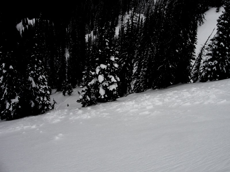
current conditions Another good shot of snow is right at our doorstep. Preceding the main event, southwest winds ramped up into the 30's and 40's early this morning along the ridges. Most of the range picked up 4" of snow in the past 24 hours and temperatures are in the teens and low 20's. Our big open bowls have taken a hard hit from the wind, but you'll find excellent riding and turning conditions on low elevation, wind sheltered, shady slopes. Additional snowpack observations and trip reports are found here.
Above... a 24 hour run of the Windy Peak weather station. Real time wind, snow, and temperatures for the Uinta's are found here |
 |
recent activity
Steep, wind drifted slopes got touchy as yesterday's wins started ramping up. Michael J was in Weber Canyon, and easily able to trigger this shallow, yet very sensitive soft slab. (Janulaitis photo) More on his travels here. A full list of Uinta avalanche activity is found here. |
| type | aspect/elevation | characteristics |
|---|

|
|
LIKELIHOOD
 LIKELY
UNLIKELY
SIZE
 LARGE
SMALL
TREND
 INCREASING DANGER
SAME
DECREASING DANGER
|
|
description
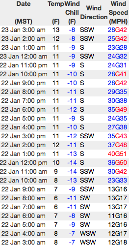
Winds are cranking at all elevations and there's no shortage of light density snow available to blow around and form drifts sensitive to our additional weight. With another storm just hours away, yesterday's manageable and predictable wind drifts will quickly turn into today's bigger, badder counterpart. In addition to the usual leeward suspect terrain getting loaded with a thick cohesive slab, drifting is also occurring further downslope and around terrain features like chutes, gullies, and sub-ridges. Avoiding steep wind drifted slopes is the ticket today. If you're getting out and about you'll need to be on your "A Game ", so gather some solid beta during your travels and reassess conditions throughout the day. Stomp on small test slopes like road cuts that are similar in aspect, elevation, and slope angle and see how they're reacting, rather than blindly sending it onto a steep slope without any good intel.
|
| type | aspect/elevation | characteristics |
|---|

|

|
LIKELIHOOD
 LIKELY
UNLIKELY
SIZE
 LARGE
SMALL
TREND
INCREASING DANGER
SAME
DECREASING DANGER
|
|
description
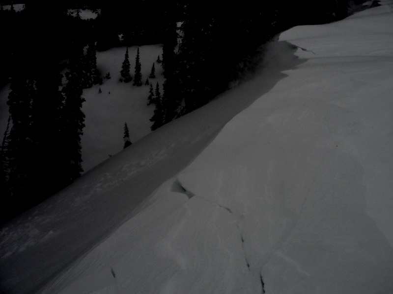
Steep, complex terrain like Gold Hill is the kind of place you could trigger a deep, dangerous avalanche. The avalanche seen in the image above broke naturally during the big cycle two weeks ago. Ted was in the hood yesterday to have a look and has interesting insight to slopes that ran big and now have weak snow snow near the ground. Ted knows the Uinta's better than anyone... click here for his take on things. (T. Scroggin photo) |
 |
weather This morning, expect strong southwest winds with hourly averages in the 40's and gusts in the 70's. High temperatures reach into the low 30's and snow starts developing in the next couple hours... it looks like a solid shot for us by late morning as a cold front slides through the region. A foot of snow is a good bet by late this afternoon. Winds gradually decrease into the 20's and 30's as they turn northwesterly this afternoon. Lingering snow showers are expected into Tuesday and Wednesday. |
| general announcements Remember your information can save lives. If you see anything we should know about, please participate in the creation of our own community avalanche advisory by submitting snow and avalanche conditions. You can call me directly at 801-231-2170, email [email protected] The information in this advisory is from the US Forest Service which is solely responsible for its content. This advisory describes general avalanche conditions and local variations always occur. The information in this advisory expires 24 hours after the date and time posted, but will be updated by 7:00 AM on Tuesday January 24th. |