25th Annual Black Diamond Fall Fundraising Party
Thursday, September 13; 6:00-10:00 PM; Black Diamond Parking Lot
25th Annual Black Diamond Fall Fundraising Party
Thursday, September 13; 6:00-10:00 PM; Black Diamond Parking Lot
| Advisory: Uintas Area Mountains | Issued by Craig Gordon for Tuesday - January 17, 2017 - 3:19am |
|---|


|
bottom line In the wind zone, at and above treeline a MODERATE avalanche danger exists. Fresh wind slabs will be reactive to our additional weight and human triggered avalanches are POSSIBLE on steep, wind drifted slopes, especially those on the leeward side of upper elevation ridges. While making up a small portion of the terrain available to ride in today, any avalanche that breaks to weaker snow, now buried deep in the snowpack will get out of hand quickly, resulting in a dangerous slide. Wind sheltered mid and lower elevation terrain offers green light conditions and in general, a LOW avalanche danger.
|
 |
current conditions Above the purple haze, skies are clear and temperatures in the mid teens and low 20's. On again... off again, north and northeast winds bumped into the teens and low 20's along the high ridges late last night, but have mellowed somewhat early this morning (see graph below). The trailheads have been packed and that means most popular riding areas got hammered. However, think outside the box a bit and you'll not only be rewarded with amazing views, but I bet you find 5 star riding and turning conditions along the way.
PHAT... Mark was at 10,100 feet, on a north aspect and found the snow depth was over 2.5 meters (over 8 ft) deep. He commented, "coverage in the Uinta Mountains is unbelievable."
Of course, today's loud pow might eventually become a player in our snowpack if it gets preserved and buried. Something to keep an eye on later this week as weather turns more stormy. Additional snowpack observations and trip reports are found here.
Lofty Lake Peak is about the best wind site for the Uinta's when it comes to East and Northeast winds.. Real time wind, snow, and temperatures for the Uinta's are found here |
 |
recent activity
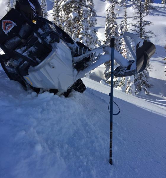
Not a huge slope by Uinta standards, but a couple riders were able to trigger an avalanche on this slope near Strawberry on Saturday, which broke to weak snow near the ground. One rider was partially buried and his sled completely buried. Fortunately, no one is injured and all is good at the end of the day. More details are found here. A full list of recent Uinta avalanche activity is found here. |
| type | aspect/elevation | characteristics |
|---|

|
|
LIKELIHOOD
 LIKELY
UNLIKELY
SIZE
 LARGE
SMALL
TREND
 INCREASING DANGER
SAME
DECREASING DANGER
|
|
description
There's plenty of light density snow available to blow around and the recent northeast winds will have no problem creating fresh drifts, sensitive to our additional weight. Found mostly near and along the leeward side of upper elevation ridges, I bet there's a pocket or two that formed around a terrain feature like a chute or gully wall. In any case, today's shallow slabs will predictably break at or below our skis, boards, or sleds. In addition, cornices have grown large and may break back further than you might expect. Your best bet with these boxcar monsters is to give 'em lots of distance. |
| type | aspect/elevation | characteristics |
|---|

|

|
LIKELIHOOD
 LIKELY
UNLIKELY
SIZE
 LARGE
SMALL
TREND
INCREASING DANGER
SAME
DECREASING DANGER
|
|
description
Not as predictable and certainly less manageable is any avalanche that breaks to weaker snow, now buried several feet deep in the mid portion of our snowpack. The good news is... time, settlement, and snowpit tests all indicate the pack is healing and much of our terrain offers a deep, strong snowpack. However, the Uinta's are a big range and I'm not entirely convinced there isn't a rogue slope or two that's just waiting for us to come along and knock the legs out from underneath it. Remember- all we need to do is find a weaknesses in the slab, collapse that slope, and now we're staring down the barrel of a very dangerous avalanche. It doesn't mean you can't get after it. It does mean that if you're charging hard today, think about the consequences of triggering a slide. Have a solid game plan and exit strategy in place and make sure to communicate that with your partners. |
 |
weather High pressure continues to build over the area through Wednesday, giving us sunny skies, light winds, and temperatures climbing into the 30's. The next storm currently looks to move through the state on Thursday, with an active pattern returning for late in the week. |
| general announcements Remember your information can save lives. If you see anything we should know about, please participate in the creation of our own community avalanche advisory by submitting snow and avalanche conditions. You can call me directly at 801-231-2170, email [email protected] The information in this advisory is from the US Forest Service which is solely responsible for its content. This advisory describes general avalanche conditions and local variations always occur. The information in this advisory expires 24 hours after the date and time posted, but will be updated by 7:00 AM on Wednesday January 18th. |