25th Annual Black Diamond Fall Fundraising Party
Thursday, September 13; 6:00-10:00 PM; Black Diamond Parking Lot
25th Annual Black Diamond Fall Fundraising Party
Thursday, September 13; 6:00-10:00 PM; Black Diamond Parking Lot
| Advisory: Uintas Area Mountains | Issued by Craig Gordon for Thursday - January 12, 2017 - 3:39am |
|---|

|
bottom line Heads up... it's game on and this is the real deal. Once triggered, today's avalanches will break deep and wide, resulting in a large, dangerous, and most likely unsurvivable avalanche. In the wind zone, at and above treeline, the avalanche danger is HIGH today. Very dangerous, human triggered avalanches are CERTAIN on steep, wind drifted slopes, especially those facing the north half of the compass, and particularly those with an easterly component to their aspect. You'll find a CONSIDERABLE avalanche danger on steep wind drifted slopes at lower and mid elevations and human triggered avalanches are PROBABLE.
|
 |
avalanche warning THE FOREST SERVICE UTAH AVALANCHE CENTER IN SALT LAKE CITY HAS CONTINUED THE BACKCOUNTRY AVALANCHE WARNING. * TIMING...THE WARNING REMAINS IN EFFECT THROUGH 6 AM MST FRIDAY. * AFFECTED AREA...THE MOUNTAINS OF NORTHERN UTAH TO INCLUDE...THE WASATCH RANGE...THE BEAR RIVER RANGE...THE MOUNTAINS OF SOUTHEAST IDAHO...THE WESTERN UNITAS...AND THE MANTI-SKYLINE PLATEAU. * AVALANCHE DANGER...THE AVALANCHE DANGER REMAINS HIGH. * REASON/IMPACTS...NUMEROUS DAYS OF HEAVY SNOWFALL AND STRONG WINDS HAVE CREATED WIDESPREAD AVALANCHE DANGER. BOTH HUMAN TRIGGERED AND NATURAL AVALANCHES ARE LIKELY. STAY OFF OF AND OUT FROM UNDER SLOPES STEEPER THAN 30 DEGREES. THIS WARNING DOES NOT APPLY TO SKI AREAS WHERE AVALANCHE HAZARD REDUCTION MEASURES ARE PERFORMED. |
 |
special announcement A very close call involving a group of motorized assisted snowboarders occurred yesterday in the Smith-Moorehouse area of Weber Canyon. We're still sifting through details, will visit the site this morning, and compile a detailed report. In the mean-time what we do know is two snowboarders triggered a large slide, were buried, recovered, and sustained very serious injuries, but at the end of the day survived. |
 |
current conditions In the past 24 hours, yet another foot of snow with just over an inch of water stacked up in the Trial Lake area, with close to 7" falling throughout the rest of the range. West and southwest winds finally relaxed around 2:00 this morning and are currently blowing 15-25 mph with a few gusts in the low 30's along the high peaks.
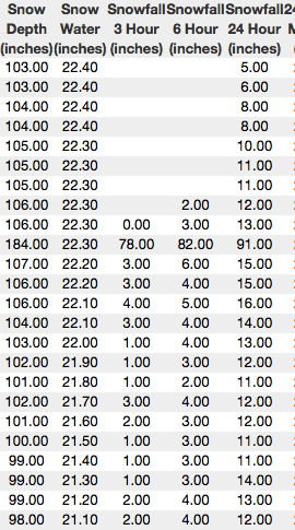
Above is a 24 hour timeline of Trial Lake (which since the first time in 7 years, just cracked the 100" total snow depth) and Windy Peak. Real time wind, snow, and temperatures for the Uinta's are found here.
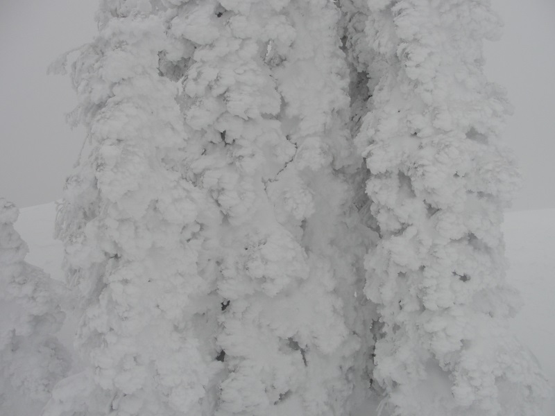
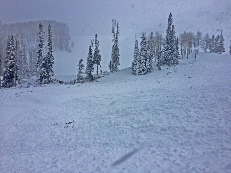
Michael J was stomping along the Duke ridge and captured this image that pretty much sums up our recent storm cycle... pasted! More on his travels here.
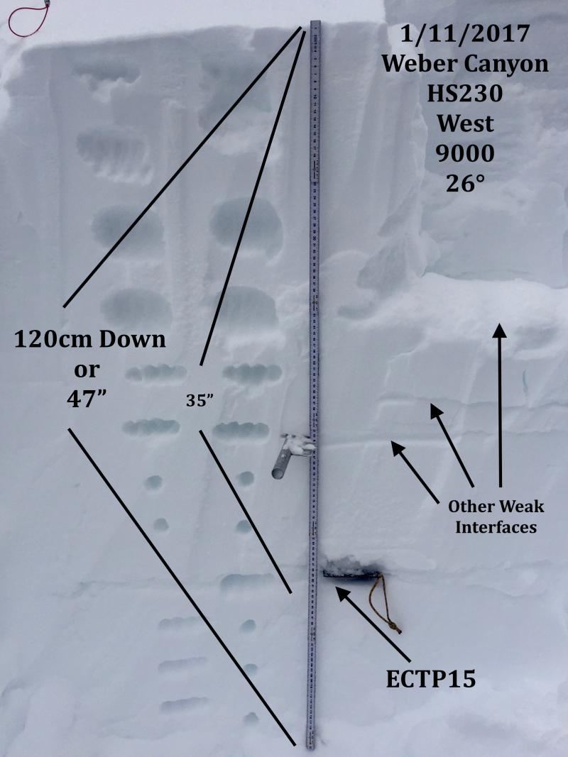
Here's what JG found in Weber Canyon with more details here. Snowpack observations and trip reports are found here. |
 |
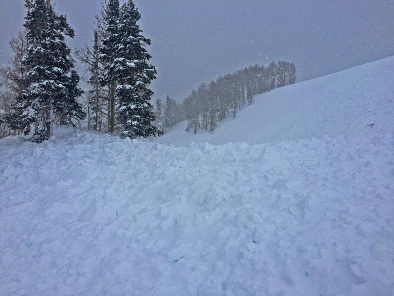
recent activity This is the type of the avalanches we're dealing with in the Uintas. When triggered they're breaking deep, they're breaking wide... they're quite possibly unsurvivable!
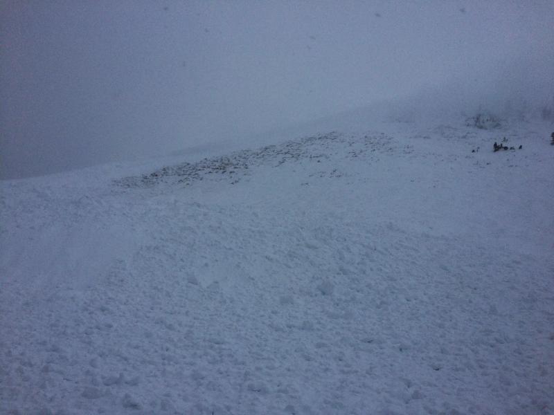
Dave Kikkert arrived just as the dust was settling on this very large natural avalanche in Upper Weber Canyon Monday. Breaking 6' feet deep and 600 plus feet wide, this tree snapping slide on a heavily wind loaded, upper elevation Northeast facing slope, broke to weak snow near the ground. More on Dave's insights here. A full list of recent Uinta avalanche activity is found here. |
| type | aspect/elevation | characteristics |
|---|

|

|
LIKELIHOOD
 LIKELY
UNLIKELY
SIZE
 LARGE
SMALL
TREND
 INCREASING DANGER
SAME
DECREASING DANGER
|
|
description
No matter how you cut it, sensitive slabs have formed at nearly every elevation and on every aspect. In addition, just due to the shear volume of snow and water we've received, avalanches are beginning to break deep and wide... yes, it's pretty dicey out there. It doesn't mean I can't ride. It does mean I need to avoid being on, near, underneath, or connected to any slope steeper than about 30 degrees. |
| type | aspect/elevation | characteristics |
|---|

|
|
LIKELIHOOD
 LIKELY
UNLIKELY
SIZE
 LARGE
SMALL
TREND
INCREASING DANGER
SAME
DECREASING DANGER
|
|
description
These are the kind of snowpack conditions that kill most all-mountain riders. You're best bet for the next few days is to simply avoid steep, wind drifted terrain, especially mid and upper elevation slopes facing the north half of the compass. While I think many slopes experienced a natural avalanche cycle, there's plenty more that wait for a trigger like us to come along and knock the legs out from underneath. Yes... terrain that hasn't avalanched is teetering on the edge. The problem is complicated because with no break in the storm cycle, it's hard to tell what slopes slid and which remain intact. In addition, the snow will feel strong and bomber under our skis, board, or sled. In either case, we've gotta think not only about the snow we're riding in, but also the snow we're riding on and there's a few buried weak layers that are straining to adjust to all this added weight. |
 |
weather Lingering snow showers stack up another couple of inches, but in general the big storm system is headed east and we should see improving weather the next few days. Westerly winds remain reasonable, blowing in the 20's along the ridges and high temperatures bump into the mid 20's. Skies begin to clear late today and overnight lows crash to near zero degrees. Partly cloudy skies with a slow warming trend are on tap for the remainder of the week into the weekend. |
| general announcements Remember your information can save lives. If you see anything we should know about, please participate in the creation of our own community avalanche advisory by submitting snow and avalanche conditions. You can call me directly at 801-231-2170, email [email protected] The information in this advisory is from the US Forest Service which is solely responsible for its content. This advisory describes general avalanche conditions and local variations always occur. The information in this advisory expires 24 hours after the date and time posted, but will be updated by 7:00 AM on Friday January 13th. |