25th Annual Black Diamond Fall Fundraising Party
Thursday, September 13; 6:00-10:00 PM; Black Diamond Parking Lot
25th Annual Black Diamond Fall Fundraising Party
Thursday, September 13; 6:00-10:00 PM; Black Diamond Parking Lot
| Advisory: Uintas Area Mountains | Issued by Craig Gordon for Wednesday - January 4, 2017 - 3:29am |
|---|

|
bottom line In upper elevation terrain, particularly leeward slopes in the wind zone, at and above treeline, a HIGH avalanche danger exists. As the storm ramps up, both human triggered and natural avalanches are VERY LIKELY on steep, wind drifted slopes, especially those facing the north half of the compass, and particularly those with an easterly component to their aspect. Once triggered, today's avalanches have the potential to break much deeper and wider than you might expect. You'll find a CONSIDERABLE avalanche danger on steep wind drifted slopes at mid elevations and human triggered avalanches are LIKELY. Even LOW elevation terrain will have pockets of MODERATE danger and human triggered avalanches are POSSIBLE on steep, wind drifted slopes. Most south facing slopes are getting stripped of snow and the avalanche danger is LOW
|
 |
avalanche watch THE FOREST SERVICE UTAH AVALANCHE CENTER IN SALT LAKE CITY HAS ISSUED A BACKCOUNTRY AVALANCHE WATCH. A VIDDY DESCRIBING THE INCREASING DANGER IS FOUND HERE * TIMING…IN EFFECT FROM 6 AM MST THIS MORNING TO 6 AM MST THURSDAY * AFFECTED AREA…FOR THE MOUNTAINS OF NORTHERN UTAH INCLUDING THE WASATCH RANGE...BEAR RIVER RANGE...UINTA MOUNTAINS. * AVALANCHE DANGER…THE AVALANCHE DANGER IS EXPECTED TO RISE TO HIGH DURING THE DAY. * IMPACTS…HEAVY SNOW COMBINED WITH WIND WILL CREATE WIDESPREAD AREAS OF UNSTABLE SNOW. BOTH HUMAN TRIGGERED AND NATURAL AVALANCHES ARE LIKELY. STAY OFF OF AND OUT FROM UNDER SLOPES STEEPER THAN 30 DEGREES. BACKCOUNTRY TRAVELERS SHOULD CONSULT WWW.UTAHAVALANCHECENTER.ORG OR CALL 1-888-999-4019 FOR MORE DETAILED INFORMATION. THIS WARNING DOES NOT APPLY TO SKI AREAS WHERE AVALANCHE HAZARD REDUCTION MEASURES ARE PERFORMED. |
 |
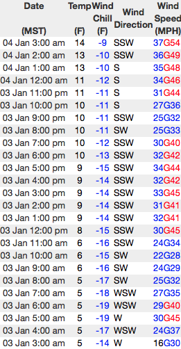
current conditions Hope you got after it Tuesday, because yesterday's powder party got crashed overnight by strong winds and rising temperatures. Currently, under mostly cloudy skies, a flurry or two is in the air, temperatures are in the mid teens and low 20's, but stealing the show are the south and southwest winds. They started ramping up late yesterday and really began blowing overnight with hourly averages in the 30's and gusts in the 50's along the high ridges. While most of our mid and upper elevation terrain is getting worked, I think you'll still find soft settled powder, but you'll need to stick with very sheltered, low elevation terrain.
The data above is a 24 hour run from Windy and Lofty Lake Peaks. Real time wind, snow, and temperatures for the Uinta's are found here.
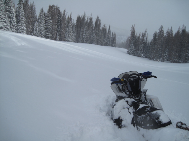
Ted found over-the-hood riding yesterday in the Whitney Basin. His take on things is found here. Snowpack observations and trip reports are found here. |
 |
recent activity
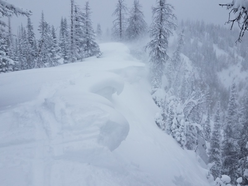
Dave Kikkert was in Upper Weber Canyon and found very sensitive soft slabs easily triggered on steep, leeward slopes. (Kikkert photo). More on his travels here.
No shortage of light fluffy snow available for transport... JG and Michael Janulaitis also found rapid wind loading and large corni developing near the ridges. Their collective insight is found here. A full list of recent Uinta avalanche activity is found here. |
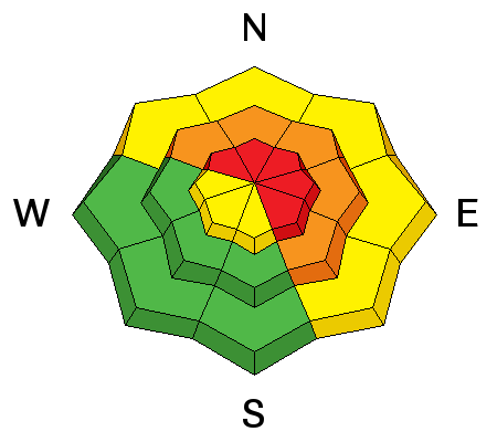
| type | aspect/elevation | characteristics |
|---|

|
|
LIKELIHOOD
 LIKELY
UNLIKELY
SIZE
 LARGE
SMALL
TREND
 INCREASING DANGER
SAME
DECREASING DANGER
|
|
description
Yesterday mornings manageable, shallow new snow avalanches, have become today's more connected, burlier, bigger, badder brother. Sensitive to our additional weight and breaking above or even adjacent to the slope we're riding, today's slabs are gonna break deep and wide and once triggered, will easily ruin your day. It doesn't mean you can't ride... it does mean you'll wanna steer clear of steep, wind drifted terrain and be on the look out for and avoid any rounded, fat, pillows of snow, especially if they feel or sound hollow like a drum. In addition, gather some BETA during your travels. Tweak a couple of road cuts and see how they're reacting and take that information to help you decide where to ride safely today.
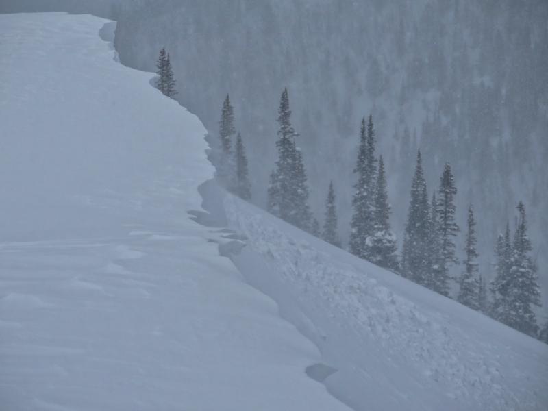
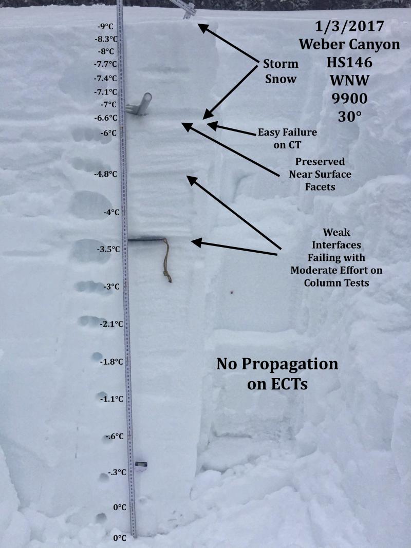
Near surface facets buried underneath the New Year storm. Easy to see with JG's beautiful pit profile where today's wind slabs are gonna fail. (JG Photo)
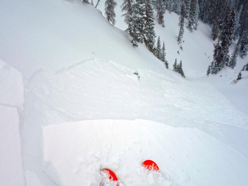
Cracks shooting out in front of your skis, board, or sled are obvious red flags. (Scroggin photo) |
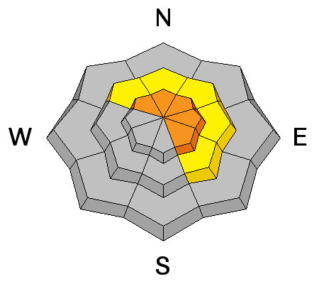
| type | aspect/elevation | characteristics |
|---|

|
|
LIKELIHOOD
 LIKELY
UNLIKELY
SIZE
 LARGE
SMALL
TREND
INCREASING DANGER
SAME
DECREASING DANGER
|
|
description
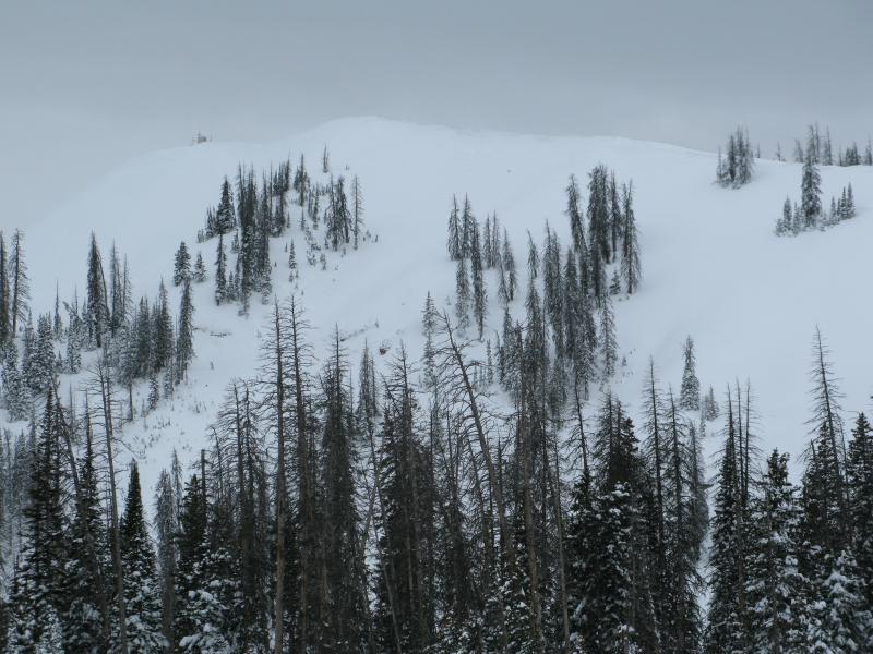
I'm thinking the upcoming storm is gonna put our weak layers to the test. While we haven't seen or heard of any slides breaking into sugary snow deep in our pack, the combination of strong winds and dense heavy snow might be the tipping point. That said, the kind of terrain I'd consider avoiding is steep, rocky, upper elevation slopes facing the north half of the compass. Places like Currant Creek Peak, pictured below, immediately come to mind.
|
 |
weather The storm gets going for us a little later today. In the mean-time, expect southwest to crank in the 50's and 60's with gusts in the 80's along the high ridges and temperatures rising into the upper 20's. Late this afternoon and tonight snow starts stacking up and I expect we'll see totals in the 2' range by sunrise Thursday. High pressure builds for the latter half of the week and we're still looking at a warm, moist storm Sunday through Tuesday with significant snow totals. A great synopsis is found here. |
| general announcements Remember your information can save lives. If you see anything we should know about, please participate in the creation of our own community avalanche advisory by submitting snow and avalanche conditions. You can call me directly at 801-231-2170, email [email protected] The information in this advisory is from the US Forest Service which is solely responsible for its content. This advisory describes general avalanche conditions and local variations always occur. The information in this advisory expires 24 hours after the date and time posted, but will be updated by 7:00 AM on Thursday January 5th. |