25th Annual Black Diamond Fall Fundraising Party
Thursday, September 13; 6:00-10:00 PM; Black Diamond Parking Lot
25th Annual Black Diamond Fall Fundraising Party
Thursday, September 13; 6:00-10:00 PM; Black Diamond Parking Lot
| Advisory: Uintas Area Mountains | Issued by Craig Gordon for Monday - January 2, 2017 - 3:38am |
|---|


|
bottom line This morning in mid and upper elevation, particularly in the wind zone, at and above treeline, a MODERATE avalanche danger exists. Human triggered avalanches are POSSIBLE on steep, wind drifted slopes, especially those facing the north half of the compass. If storm totals exceed forecast projections, the avalanche danger may rise to CONSIDERABLE in this same terrain, meaning human triggered avalanches are LIKELY. Out of the wind, our snowpack is well behaved and predictable and the avalanche danger is LOW
|
 |
special announcement Give the gift that keeps giving and help save a life by doing so. Sign up for one of our Riding Skills and Avy Awareness Workshops given by sledders... for sledders. We've got two workshops this year- Thursday Jan 19th evening, followed by an on the snow field day Saturday Jan. 21st. Details here. Thursday Feb. 9th evening, followed by an on the snow field day Saturday Feb. 11th. Details here. |
 |
current conditions Under mostly cloudy skies, temperatures are in the teens and low 20's. Light snow began falling right around midnight, and so far, about an inch or two stacked up across the range. The bigger news is the wind.... and man, it's been cranking 50-70 mph along the high ridges. Of course, much of our high alpine terrain is getting nuked, so you might wanna think about sticking to low elevation, wind sheltered terrain today where you'll find soft settled snow on a go-anywhere base.
The data above is a 12 hour run from Windy and Lofty Peaks... ouch! Real time wind, snow, and temperatures for the Uinta's are found here. Snowpack observations and trip reports are found here. |
 |
recent activity
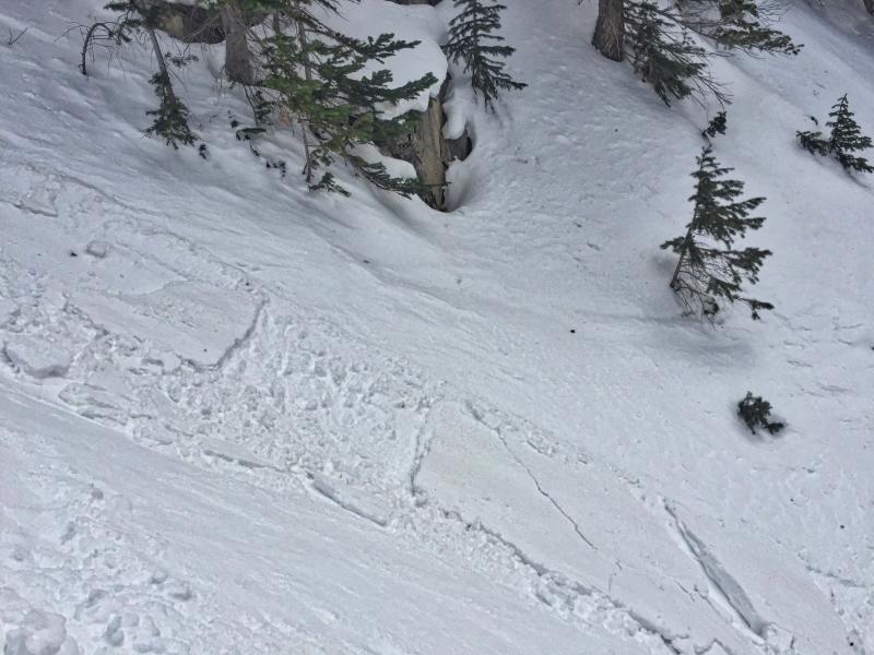
JG found this shallow, yet reactive pocket in a wind sheltered area of Hoyt Peak yesterday and noted... "the snow surface is very weak right now and the surface hoar and near surface facets are going to become our next weak layer once buried by this week's upcoming unsettled weather." (JG photo) More on his travels found here. A full list of recent Uinta avalanche activity is found here. |
| type | aspect/elevation | characteristics |
|---|

|

|
LIKELIHOOD
 LIKELY
UNLIKELY
SIZE
 LARGE
SMALL
TREND
 INCREASING DANGER
SAME
DECREASING DANGER
|
|
description
We've got a saying in the avalanche business... "today's loud powder is tomorrow's weak layer". Of course, it's not a problem until the weak layer gets covered over with new snow and unfortunately that's exactly how our setup is taking shape for today. Overnight wind and snow now blankets the weak surface snow formed last week, when the weather turned clear and cold and storm track switched to high and dry. The good news is... these fragile crystals are no match for the strong winds and much of our problem in upper elevation terrain has been blown away. The bad news is... in wind sheltered terrain where we normally ride during storm days, I suspect this weak layer is preserved and covered over with fresh wind drifts. While mostly manageable in size, I bet these pockets are going to be sensitive to our additional weight and could pop out above you when you're low on the slope. Today you'll wanna be on the look out for and avoid any round, fat, pillows of snow. In addition, gather some BETA during your travels. Tweak a couple of road cuts and see how they're reacting and take that information to help you decide where to ride safely today. |
| type | aspect/elevation | characteristics |
|---|

|

|
LIKELIHOOD
 LIKELY
UNLIKELY
SIZE
 LARGE
SMALL
TREND
 INCREASING DANGER
SAME
DECREASING DANGER
|
|
description
Feels to me like our persistent weaknesses are dormant for the moment and you'd really have to go out of your way to provoke a piece of snow that breaks to weak layers near the ground. Unlikely... yes. Impossible... no. Steep, rocky, upper elevation slopes facing the north half of the compass should still be considered suspect. If you're getting into complex terrain like steep, upper elevation, north facing bowls and chutes, think of the worst case scenario and at the very least, have an exit strategy ready to pull out of the queue.
When I think of a place that harbors weak snow and the potential to trigger a deep, dangerous avalanche, Currant Creek Peak always comes to mind. We took a spin out there earlier last week and found mostly supportable snow and a solid snowpack. But with all the great riding options available, there's no reason to tease this slope and roll the dice... this is exactly the type of complex terrain I'd steer clear of. |
 |
weather A cold front slides through our region today and then stalls across central Utah, giving us a good shot of snow early this morning, before becoming more showery by about lunchtime. West and southwest winds are going back off somewhat, but will still be a nuisance, blowing 30-50 mph along the high ridges. Temperatures don't vary much from where we're at this morning and dip into the single digits overnight. Light snow lingers tonight into Tuesday morning with storm totals in the 4"-8" range. More snow with a warming trend is on tap for Wednesday. |
| general announcements Remember your information can save lives. If you see anything we should know about, please participate in the creation of our own community avalanche advisory by submitting snow and avalanche conditions. You can call me directly at 801-231-2170, email [email protected] The information in this advisory is from the US Forest Service which is solely responsible for its content. This advisory describes general avalanche conditions and local variations always occur. The information in this advisory expires 24 hours after the date and time posted, but will be updated by 7:00 AM on Tuesday January 3rd. |