25th Annual Black Diamond Fall Fundraising Party
Thursday, September 13; 6:00-10:00 PM; Black Diamond Parking Lot
25th Annual Black Diamond Fall Fundraising Party
Thursday, September 13; 6:00-10:00 PM; Black Diamond Parking Lot
| Advisory: Uintas Area Mountains | Issued by Craig Gordon for Sunday - January 1, 2017 - 4:57am |
|---|

|
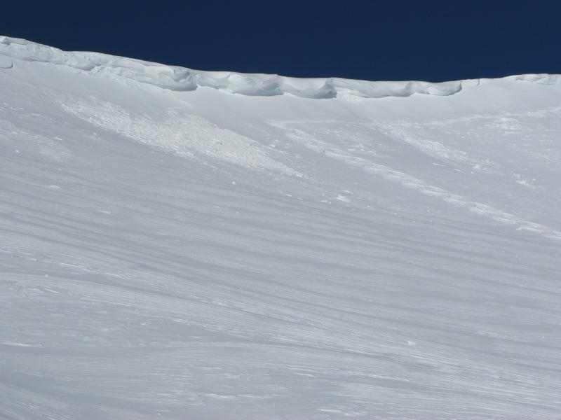
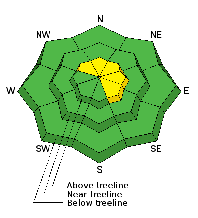
bottom line Making up a small portion of the terrain available to ride in, pockets of MODERATE avalanche danger exist today. In the wind zone, at and above treeline, human triggered avalanches are POSSIBLE on steep, wind drifted slopes, especially those facing the north half of the compass. Out of the wind, our snowpack is well behaved and predictable and the avalanche danger is LOW
|
 |
special announcement Give the gift that keeps giving and help save a life by doing so. Sign up for one of our Riding Skills and Avy Awareness Workshops given by sledders... for sledders. We've got two workshops this year- Thursday Jan 19th evening, followed by an on the snow field day Saturday Jan. 21st. Details here. Thursday Feb. 9th evening, followed by an on the snow field day Saturday Feb. 11th. Details here. |
 |
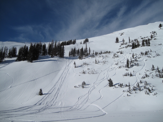
current conditions Good morning and Happy New Year! High pressure is shifting to the east and a cold storm is on the door step. In the mean-time, skies are clear, temperatures in the low teens, and southwest winds starting increasing around 3:00 this morning, currently blowing 20-30 mph along the high ridges. Most of our big, open, upper elevation bowls took a hard hit from Tuesdays wind, but lose a little elevation and you'll be treated to premium riding and turning conditions.
More snowpack observations and trip reports are found here.
Ted was in the Moffit Basin Friday and noted that riders are taking advantage of mostly stable snow and getting into some big terrain without incident. More on his travels found here. (Scroggin photo) Snowpack observations and trip reports are found here. Real time wind, snow, and temperatures for the Uinta's are found here. |
 |
recent activity
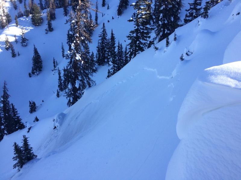
About the only game in town yesterday was this shallow wind slab along the leeward side of an upper elevation ridge in Humpy Basin. (Kikkert photo) A full list of recent Uinta avalanche activity is found here. |
| type | aspect/elevation | characteristics |
|---|

|
|
LIKELIHOOD
 LIKELY
UNLIKELY
SIZE
 LARGE
SMALL
TREND
 INCREASING DANGER
SAME
DECREASING DANGER
|
|
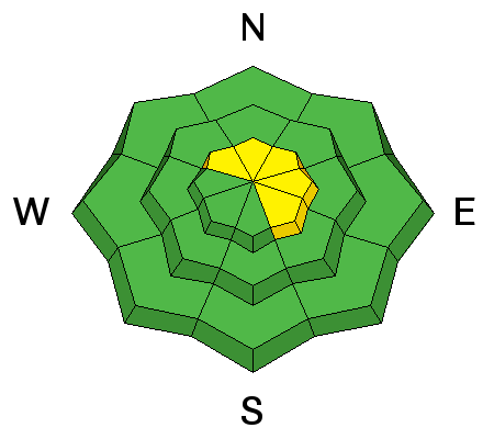
description
While not particularly connected and making up a small portion of the terrain available to ride in, pockety wind drifts sensitive to our additional weight can still be found on steep, leeward slopes in the wind zone. A bit less sensitive than previous days, recent drifts could none-the-less break a little deeper and wider than you might expect. I'd continue to avoid any fat, rounded piece of snow, especially if it sounds hollow like a drum.
A quick visual scan of the ridges can help you determine where the wind's been blowing. |
| type | aspect/elevation | characteristics |
|---|

|
|
LIKELIHOOD
 LIKELY
UNLIKELY
SIZE
 LARGE
SMALL
TREND
 INCREASING DANGER
SAME
DECREASING DANGER
|
|
description
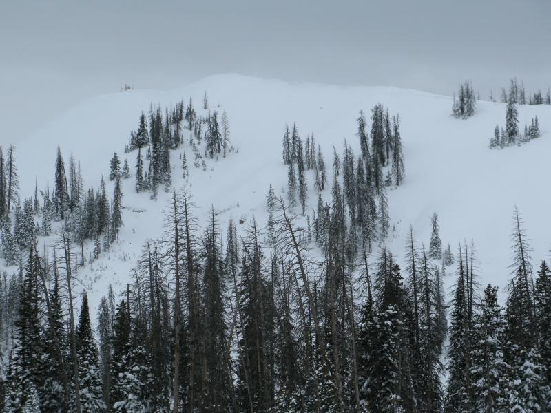
Feels to me like our persistent weaknesses are dormant for the moment and you'd really have to go out of your way to provoke a piece of snow that breaks to weak layers near the ground. Unlikely... yes. Impossible... no. Steep, rocky, upper elevation slopes facing the north half of the compass should still be considered suspect. If you're getting into complex terrain like steep, upper elevation, north facing bowls and chutes, think of the worst case scenario and at the very least, have an exit strategy ready to pull out of the queue.
When I think of a place that harbors weak snow and the potential to trigger a deep, dangerous avalanche, Currant Creek Peak always comes to mind. We took a spin out there earlier this week and found mostly supportable snow and a solid snowpack. But with all the great riding options available, there's no reason to tease this slope and roll the dice... this is exactly the type of complex terrain I'd steer clear of. |
 |
weather After a sunny start, clouds increase today ahead of an approaching cold front. Southwest winds bump into the 30's and temperatures top off in the upper 20's. Snow develops tonight, winds shift to the west and northwest, and temperatures dive into the single digits. This isn't a big storm, but perhaps we'll pickup 4"-8" of new snow with scattered snow showers lingering through Monday. An unsettled pattern continues for much of the upcoming week, though confidence is low on the details. |
| general announcements Remember your information can save lives. If you see anything we should know about, please participate in the creation of our own community avalanche advisory by submitting snow and avalanche conditions. You can call me directly at 801-231-2170, email [email protected] The information in this advisory is from the US Forest Service which is solely responsible for its content. This advisory describes general avalanche conditions and local variations always occur. The information in this advisory expires 24 hours after the date and time posted, but will be updated by 7:00 AM on Monday January 2nd. |