25th Annual Black Diamond Fall Fundraising Party
Thursday, September 13; 6:00-10:00 PM; Black Diamond Parking Lot
25th Annual Black Diamond Fall Fundraising Party
Thursday, September 13; 6:00-10:00 PM; Black Diamond Parking Lot
| Advisory: Uintas Area Mountains | Issued by Craig Gordon for Wednesday - December 28, 2016 - 3:39am |
|---|

|
bottom line Heads up... the avalanche danger is slightly higher on the south half of the range from Trial Lake to Currant Creek to Daniels where more snow stacked up during the big Christmas storm. At mid and upper elevations, particularly in along the leeward side of ridges in the wind zone, the avalanche danger is MODERATE today. Human triggered avalanches are POSSIBLE on all steep, wind drifted slopes. Once triggered, today's avalanches have the potential to break deeper and wider than you might expect. Lose a little elevation and you lose the problem. Wind sheltered terrain and most south facing slopes offer generally LOW avalanche danger.
|
 |
special announcement Give the gift that keeps giving and help save a life by doing so. Sign up for one of our Riding Skills and Avy Awareness Workshops given by sledders... for sledders. We've got two workshops this year- Thursday Jan 19th evening, followed by an on the snow field day Saturday Jan. 21st. Details here. Thursday Feb. 9th evening, followed by an on the snow field day Saturday Feb. 11th. Details here. |
 |
current conditions Under mostly cloudy skies, a weak cold front sliding to the north of our region delivered an inch or two of snow early this morning. Light snow is still falling and temperatures are in the low to mid 20's. Yesterday's annoying west and southwest winds blasted the ridges, but calmed down around 2:00 this morning and are currently blowing 25-35 mph along the high peaks. Some of our big open bowls took a hard hit and are wind jacked and funky today, but lose a little elevation and you'll be treated to some of the best riding and turning conditions we've seen in a few years. Real time wind, snow, and temperatures for the Uinta's are found here. Recent observations are found here.
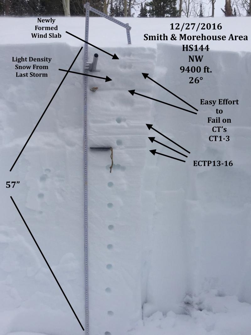
JG was in the Smith-Moorehouse zone yesterday and found mostly stable snow in sheltered terrain with a little drifting and sensitive wind slab forming on upper elevation slopes. More on his travels and most excellent insight on our current snowpack can be found here. |
 |
recent activity
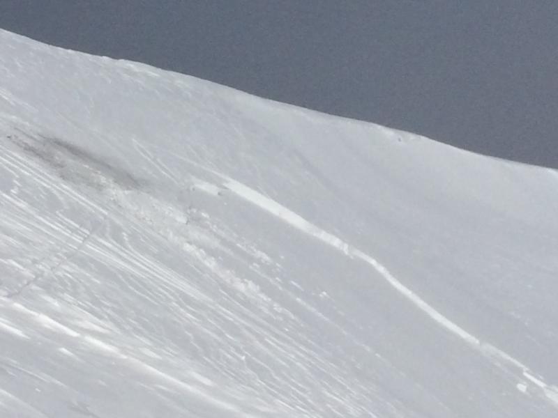
With a little coaxing a few of my colleagues were able to initiate this wind slab on steep, upper elevation, wind drifted slope in Upper Weber Canyon. (C. Brown photo) A full list of recent Uinta avalanche activity is found here. |
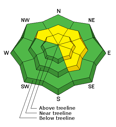
| type | aspect/elevation | characteristics |
|---|

|
|
LIKELIHOOD
 LIKELY
UNLIKELY
SIZE
 LARGE
SMALL
TREND
 INCREASING DANGER
SAME
DECREASING DANGER
|
|
description
West and southwest winds increased midday yesterday, nuking into the 40's and 50's along the ridges, creating stiff wind slabs on the leeward side of upper elevation ridges. While not particularly connected and a bit less sensitive than yesterday, today's drifts could none-the-less break a little deeper and wider than you might expect. With all the great riding in wind sheltered terrain, why pull on the dogs tail and take a chance on being bitten. I'd continue to avoid any fat, rounded piece of snow, especially if it sounds hollow like a drum. However, if your travels take you into steep, committing terrain, tweak a few small test slopes or road cuts similar in aspect, elevation, and slope angle to what you want to ride and get a feel for the type of avalanche dragon you're dealing with before blindly sending it into big terrain. And remember- we've added a substantial amount of snow to the pack, especially on the south half of the range, and any avalanche triggered today has the potential to break into a variety of layers now buried several feet deep in our snowpack.
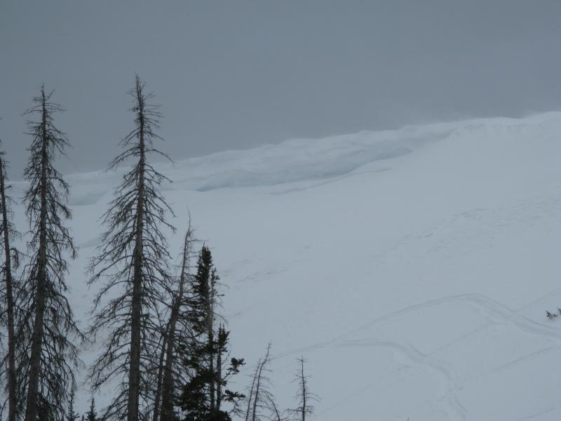
A quick visual scan of the ridges can help you determine where the wind's been blowing and the type of terrain you wanna avoid. |
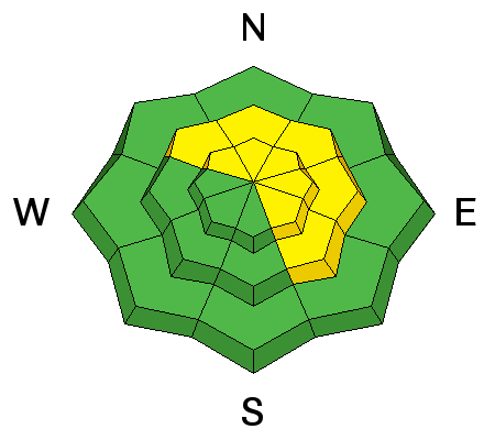
| type | aspect/elevation | characteristics |
|---|

|
|
LIKELIHOOD
 LIKELY
UNLIKELY
SIZE
 LARGE
SMALL
TREND
INCREASING DANGER
SAME
DECREASING DANGER
|
|
description
Overall our snowpack looks great and most slopes across the range are comfortable in their own skin. However, we do have a few problem children and terrain where the snowpack has remained thin all season, particularly steep, rocky, upper elevation slopes facing the north half of the compass should be considered suspect. Once triggered, an avalanche in terrain with these characteristics can easily get out of hand. If you're getting into the big north facing bowls, think about the consequences of triggering an avalanche that breaks to weak layers near the ground and at the very least, have an exit strategy.
When I think of a place that harbors weak snow and the potential to trigger a deep, dangerous avalanche, Currant Creek Peak always comes to mind. We took a spin out there yesterday and found mostly supportable snow and a solid snowpack. But with all the great riding options available, there's no reason to tease this slope and roll the dice... this is exactly the type of complex terrain I'd steer clear of. |
 |
weather A storm system to the north gives us mostly cloudy skies with a slight chance of snow showers in the morning, becoming partly cloudy in the afternoon. Westerly winds will be a nuisance, blowing in the 30's along the ridges. High temperatures don't vary much from where we're at this morning, and overnight lows under clearing skies dip into the single digits. High pressure builds for the latter part of the week bringing warmer temperatures. Unsettled weather is slated to return late in the weekend. |
| general announcements Remember your information can save lives. If you see anything we should know about, please participate in the creation of our own community avalanche advisory by submitting snow and avalanche conditions. You can call me directly at 801-231-2170, email [email protected] The information in this advisory is from the US Forest Service which is solely responsible for its content. This advisory describes general avalanche conditions and local variations always occur. The information in this advisory expires 24 hours after the date and time posted, but will be updated by 7:00 AM on Thursday December 29th. |