25th Annual Black Diamond Fall Fundraising Party
Thursday, September 13; 6:00-10:00 PM; Black Diamond Parking Lot
25th Annual Black Diamond Fall Fundraising Party
Thursday, September 13; 6:00-10:00 PM; Black Diamond Parking Lot
| Advisory: Uintas Area Mountains | Issued by Craig Gordon for Tuesday - December 27, 2016 - 3:48am |
|---|

|
bottom line Heads up... the avalanche danger is higher on the south half of the range from Trial Lake to Currant Creek to Daniels. On steep upper elevation slopes, particularly in the wind zone, the avalanche danger is MODERATE today. Human triggered avalanches are POSSIBLE, especially on all steep, wind drifted slopes. Once triggered, today's avalanches have the potential to break deeper and wider than you might expect. Lose a little elevation and you lose the problem. Wind sheltered terrain and most south facing slopes offer generally LOW avalanche danger.
|
 |
special announcement Give the gift that keeps giving and help save a life by doing so. Sign up for one of our Riding Skills and Avy Awareness Workshops given by sledders... for sledders. We've got two workshops this year- Thursday Jan 19th evening, followed by an on the snow field day Saturday Jan. 21st. Details here. Thursday Feb. 9th evening, followed by an on the snow field day Saturday Feb. 11th. Details here. |
 |
current conditions The Boss and I say... Merry Christmas Baby! This morning, skies are clear, temperatures in the low single digits, and winds are light and variable. The Christmas storm delivered a healthy dose of fresh snow with the south half of the range clocking in as the big winner. From Trial Lake to Daniels and over to Currant Creek, nearly two feet of snow stacked up since late Friday. The North Slope never really got in on the act and storm totals are just over a foot. In either case, there's a go anywhere base, providing some of the best riding and turning conditions we've seen in a few years. Real time wind, snow, and temperatures for the Uinta's are found here. Recent observations are found here.
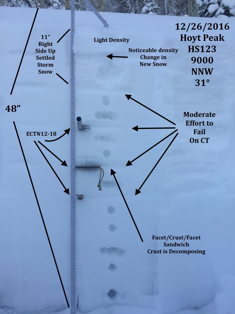
JG's brilliant pit profile clearly illustrates why our snowpack is mostly bomber right now. More on his travels to the Hoyt Peak environs are found here. |
 |
recent activity No news of the weird from our hood. A full list of recent Uinta avalanche activity is found here. |
| type | aspect/elevation | characteristics |
|---|

|
|
LIKELIHOOD
 LIKELY
UNLIKELY
SIZE
 LARGE
SMALL
TREND
 INCREASING DANGER
SAME
DECREASING DANGER
|
|
description
Most of the wind slabs that formed during the Christmas storm have settled out to a large degree and won't be nearly as sensitive today. However, since winds were all over the place, particularly as the storm was ramping up on Friday and Saturday, you definitely don't want to get too complacent thinking all terrain is good to go. In addition, winds are forecast to increase later today, so there will be a fresh new batch of slabs forming as the day wares on. In either case, if your travels take you into steep, committing terrain, tweak a few small test slopes or road cuts similar in aspect, elevation, and slope angle to what you want to ride and get a feel for the type of avalanche dragon you're dealing with. Found mostly on the leeward side of upper elevation ridges, I'd continue to avoid any fat, rounded piece of snow, especially if it sounds hollow like a drum. And remember- we've added a substantial amount of snow to the pack, especially on the south half of the range, and any avalanche triggered today has the potential to break into a variety of layers now buried several feet deep in our snowpack. |
| type | aspect/elevation | characteristics |
|---|

|

|
LIKELIHOOD
 LIKELY
UNLIKELY
SIZE
 LARGE
SMALL
TREND
 INCREASING DANGER
SAME
DECREASING DANGER
|
|
description
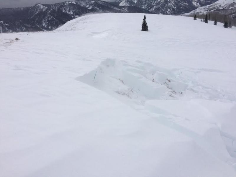
Overall our snowpack looks great and most slopes across the range are comfortable in their own skin. However, we do have a few problem children and terrain where the snowpack has remained thin all season, particularly steep, rocky, upper elevation slopes facing the north half of the compass should be considered suspect. Once triggered, an avalanche in terrain with these characteristics can easily get out of hand. If you're getting into the big north facing bowls, think about the consequences of triggering an avalanche that breaks to weak layers near the ground and at the very least, have an exit strategy.
This small pocket was triggered by a snowcat along a ridge this weekend. Whilst not particularly large, it broke to weak snow near the ground and gives us a clue to what we're dealing with in this department. (Boyer photo) |
 |
weather After a sunny start, we can expect increasing clouds as a weather system brushes by the area late today through tonight. Winds increase throughout the day and should be cranking into the 40's and 50's by about dinner time. High temperatures reach into the mid 20's with overnight lows dipping into the teens. A few scattered snow showers are on tap for tonight into Wednesday, but accumulation look negligible. High pressure follows for the middle to latter portion of the week with warming temperatures. |
| general announcements Remember your information can save lives. If you see anything we should know about, please participate in the creation of our own community avalanche advisory by submitting snow and avalanche conditions. You can call me directly at 801-231-2170, email [email protected] The information in this advisory is from the US Forest Service which is solely responsible for its content. This advisory describes general avalanche conditions and local variations always occur. The information in this advisory expires 24 hours after the date and time posted, but will be updated by 7:00 AM on Wednesday December 28th. |