25th Annual Black Diamond Fall Fundraising Party
Thursday, September 13; 6:00-10:00 PM; Black Diamond Parking Lot
25th Annual Black Diamond Fall Fundraising Party
Thursday, September 13; 6:00-10:00 PM; Black Diamond Parking Lot
| Advisory: Uintas Area Mountains | Issued by Craig Gordon for Sunday - December 25, 2016 - 4:27am |
|---|

|
bottom line Heads up... the avalanche danger is higher on the south half of the range from Trial Lake to Daniels. On steep upper elevation slopes, particularly in the wind zone, the avalanche danger is HIGH this morning. Human triggered avalanches are VERY LIKELY, especially on all steep, wind drifted slopes. Once triggered, today's avalanches have the potential to break deeper and wider than you might expect. Even mid elevation terrain has gotten in on the act where you'll find a CONSIDERABLE danger. Human triggered avalanches are PROBABLE in steep terrain with recent deposits of wind drifted snow. Low elevation wind sheltered terrain and most south facing slopes offer generally LOW avalanche danger.
|
 |
special announcement Looking for a last minute stocking stuffer? Give the gift that keeps giving and help save a life by doing so. Sign up for one of our Riding Skills and Avy Awareness Workshops given by sledders... for sledders. We've got two workshops this year- Thursday Jan 19th evening, followed by an on the snow field day Saturday Jan. 21st. Details here. Thursday Feb. 9th evening, followed by an on the snow field day Saturday Feb. 11th. Details here. |
 |
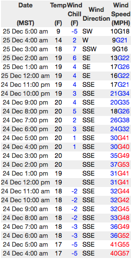
current conditions The Boss and I say... Merry Christmas Baby! Wow... what a great storm for the south half of the range which got pasted with 14" of snow and just a little over an inch of H2O. The North Slope got invited to the party late, picking up just 5" of fresh snow. Yesterdays nuking south and southeast winds have finally clamed down, they're switching to the west and are blowing 10-20 mph along the high peaks. Riding and turning conditions are gonna be epic today, especially on wind sheltered slopes, where you'll find over-the-hood and over-the-head snow on a mostly supportable base. Real time wind, snow, and temperatures for the Uinta's are found here. Recent observations are found here.
For over 24 hours, winds have been cranking along the high ridges. |
 |
recent activity No news of the weird from our hood... meanwhile in the Wasatch though.
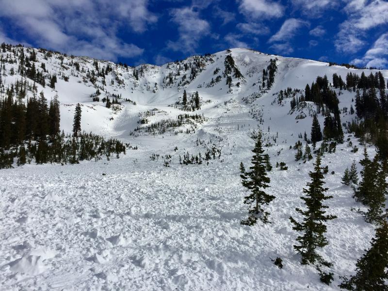
Looks like a Uinta avalanche doesn't it? Two extremely lucky riders came out on top after a very close call in Little Cottonwood Canyon late Monday. (M. Staples photo) A brilliant write up is found here. A full list of recent Uinta avalanche activity is found here. |
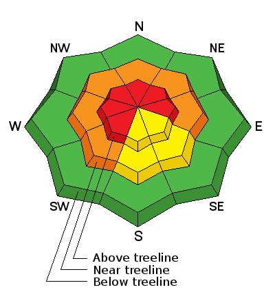
| type | aspect/elevation | characteristics |
|---|

|
|
LIKELIHOOD
 LIKELY
UNLIKELY
SIZE
 LARGE
SMALL
TREND
 INCREASING DANGER
SAME
DECREASING DANGER
|
|
description
South and southeast winds cranked yesterday with hourly averages in the 30's, gusting to 60 mph along the high ridges. With plenty of fresh snow to work with, we found slabs sensitive to our additional weight and they were breaking up to a foot deep by about midday. The big surprise was due to the unusual direction of the wind, drifts were forming all over the place. Here's the tricky part... yesterday's slabs are now covered over with more snow, making them harder to detect. You're best defense today is a good offense. Simply avoid any fat, rounded piece of snow, especially if it sounds hollow like a drum. And remember- sustained easterly winds are unusual for us. Unusual weather creates unusual avalanches. So today, you'll want to be on the lookout for drifts on slopes with a westerly component to their aspect.
Along the high ridges, yesterdays southerly winds stripped many upper elevation slopes down to the ground. Remember- that snow has gotta go somewhere.
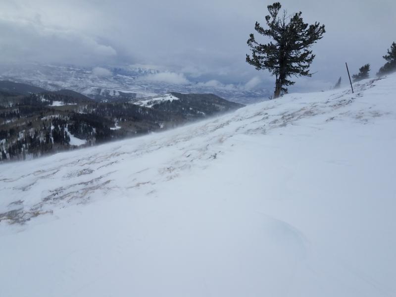
Today you'll find fresh drifts sensitive to our additional along the leeward side of upper elevation ridges and around terrain features like chutes and gullies. (Janulaitis photos) |
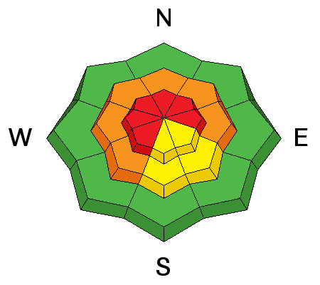
| type | aspect/elevation | characteristics |
|---|

|

|
LIKELIHOOD
 LIKELY
UNLIKELY
SIZE
 LARGE
SMALL
TREND
INCREASING DANGER
SAME
DECREASING DANGER
|
|
description
Overall our snowpack looks great and most slopes across the range are gonna handle the Christmas storm. However, we do have a few problem children and terrain where the snowpack has remained thin all season, particularly steep, rocky, upper elevation slopes facing the north half of the compass remain suspect. Once triggered, an avalanche in terrain with these characteristics can easily get out of hand. I'd give the big north facing bowls a few days and let them adjust to the recent storm.
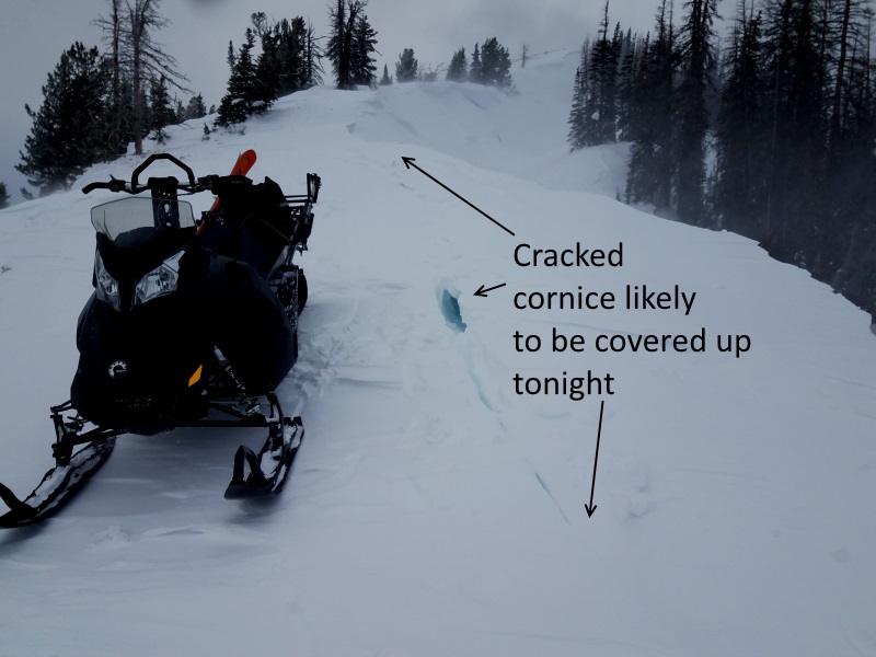
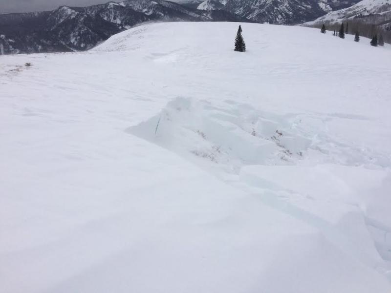
This small pocket was triggered by a snowcat along a ridge yesterday. Whilst not particularly large, it broke to weak snow near the ground... you can clearly see what we're dealing with in this department. (Boyer photo) |
 |
weather The North Slope will get in the game and snow starts stacking up this morning as the flow turns west-northwest. We should see about a foot or so piling up during the day. West-northwest winds bump into the 20's and 30's along the high ridges and temperatures start dipping into the mid teens during the day, crashing to single digits overnight. Snow tapers off tonight, ending by Monday morning with much colder air settling in for early in the week. |
| general announcements Remember your information can save lives. If you see anything we should know about, please participate in the creation of our own community avalanche advisory by submitting snow and avalanche conditions. You can call me directly at 801-231-2170, email [email protected] The information in this advisory is from the US Forest Service which is solely responsible for its content. This advisory describes general avalanche conditions and local variations always occur. The information in this advisory expires 24 hours after the date and time posted, but will be updated by 7:00 AM on Monday December 26th. |