25th Annual Black Diamond Fall Fundraising Party
Thursday, September 13; 6:00-10:00 PM; Black Diamond Parking Lot
25th Annual Black Diamond Fall Fundraising Party
Thursday, September 13; 6:00-10:00 PM; Black Diamond Parking Lot
| Advisory: Uintas Area Mountains | Issued by Craig Gordon for Sunday - December 18, 2016 - 4:27am |
|---|

|
bottom line In the wind zone at upper elevations, the avalanche danger is CONSIDERABLE today. Human triggered avalanches are PROBABLE, especially on steep, wind drifted slopes facing the north half of the compass. Once triggered, today's avalanches have the potential to be deep, dangerous, and possibly unsurvivable. While not widespread, mid elevations have seen their fair share of wind and a MODERATE avalanche danger exists. Human triggered avalanches are POSSIBLE on steep slopes with recent deposits of wind drifted snow. Looking for LOW avalanche danger? You can have a blast in big open meadows, low angle slopes, or simply stick to terrain facing the south half of the compass that have no old snow issues.
|
 |
current conditions A cold northerly flow over the region allowed skies to clear overnight and temperatures crashed into the fuel gelling zone. Currently, most mountain locations are registering -10 to -18 degrees and northwest winds are blowing in the upper 20's along the ridges. Factor in a little wind chill and it's -40 degrees... even I might consider wearing a hat. Friday's big storm pasted the region with a couple feet of snow, a couple inches of water, and riding and turning conditions are about as good as they get Real time wind, snow, and temperatures for the Uinta's are found here. Recent observations are found here.
Mark Staples was out with a few athletes from the Boondockers crew and confirms... it's over-the-hood and over-the head! Check out Mark's trip report and great video recap here.
JG's most excellent pit diagram tells it like it is. He was in Upper Weber Canyon yesterday and his obs are found here. |
 |
recent activity
There's lots of evidence the region went through a widespread natural avalanche cycle during the peak of Friday's craziness. Yesterday, Ted was in Whitney Basin and spotted this slide on Double Hill.More on his travels and top notch observations can be found here. (Scroggin photo)
This avalanche was triggered Friday during the height of weather insanity by dropping a small piece of cornice onto the steep, north facing slope below. It triggered a fresh wind drift, which quickly broke into old snow near the ground. More on this slide found here. (C.Brown photo) A full list of recent avalanche activity is found here. |
| type | aspect/elevation | characteristics |
|---|

|

|
LIKELIHOOD
 LIKELY
UNLIKELY
SIZE
 LARGE
SMALL
TREND
 INCREASING DANGER
SAME
DECREASING DANGER
|
|
description
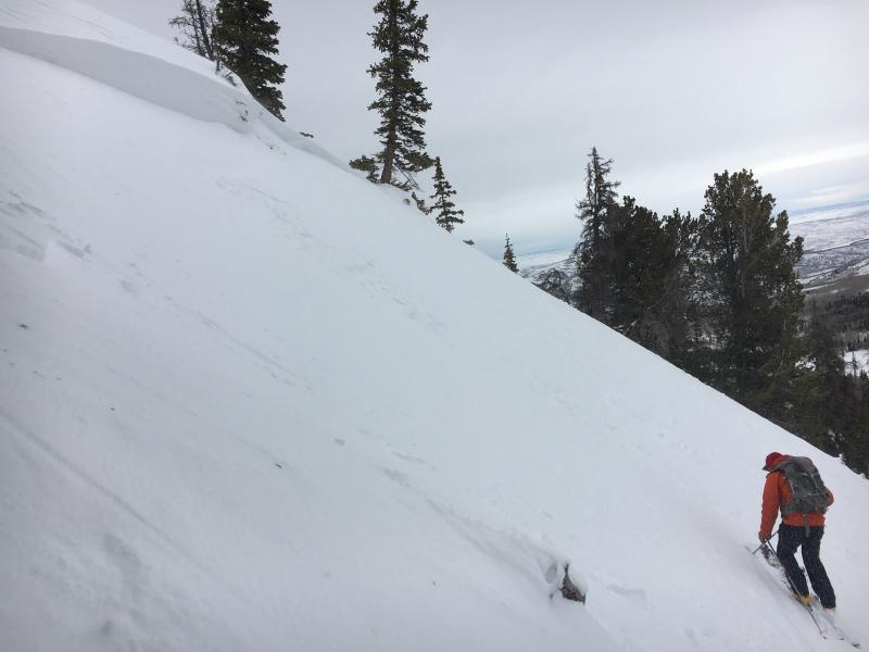
The snowpack is rapidly adjusting to the big storm and in most terrain, I think it's getting comfortable in its own skin, we're starting to turn the corner towards stable snow, and it's good to go... and that's good news. The bad news is, today is still gonna be a bit tricky because a lot of our big terrain avalanched naturally sometime Friday, but you'll need a keen eye to tell which slopes have slid and which remain intact, just waiting for a trigger like us to come along and knock the legs out from underneath. Found mostly on steep, rocky, upper elevation slopes facing the north half of the compass, todays slabs may be harder to initiate, but once triggered, have the potential to break into weak layers now buried deep in our snowpack. And this is the scary part of the deal. If you trigger an avalanche that breaks to old snow near the ground you're smoked... done... you don't get to enjoy the holidays with your family... it has the potential to be unsurvivable. Think about it for a moment. We've added a ton of water weight and nearly doubled our snowpack depths this week. This a patience game. We've got a great looking snowpack starting to develop and we enjoy a long winter in Utah. The big terrain just needs another day or two.
This is the type of avalanche dragon we're dealing with in steep, rocky terrain facing the north half of the compass. (C.Brown photo) |
| type | aspect/elevation | characteristics |
|---|

|
|
LIKELIHOOD
LIKELY
UNLIKELY
SIZE
 LARGE
SMALL
TREND
 INCREASING DANGER
SAME
DECREASING DANGER
|
|
description
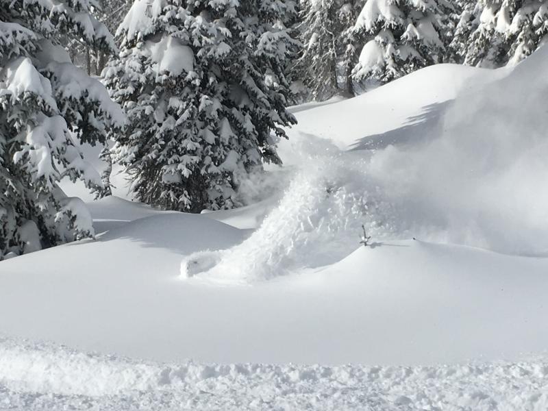
Wind drifts along the leeward side of upper elevation ridges and around terrain features like chutes, gullies, and sub-ridges are today's second avalanche issue. They're easy to detect by their fat, rounded, humpback whale-like appearance and easy to avoid. Once triggered, a fresh wind drift can easily break deeper and wider than you might expect.
We triggered this fresh drift on Thursday, just when the big storm was ramping up. |
 |
weather Sunny skies and very cold temperatures are on tap today with highs barely cracking into the upper single digits. Northwest winds blow in the 15-25 mph range along the high ridges. Lows tonight dip below zero with a slow warming trend developing Monday and Tuesday ahead of the next storm system which looks like a minor affair. |
| general announcements Remember your information can save lives. If you see anything we should know about, please participate in the creation of our own community avalanche advisory by submitting snow and avalanche conditions. You can call me directly at 801-231-2170, email [email protected] The information in this advisory is from the US Forest Service which is solely responsible for its content. This advisory describes general avalanche conditions and local variations always occur. The information in this advisory expires 24 hours after the date and time posted, but will be updated by 7:00 AM on Monday December 19th. |