25th Annual Black Diamond Fall Fundraising Party
Thursday, September 13; 6:00-10:00 PM; Black Diamond Parking Lot
25th Annual Black Diamond Fall Fundraising Party
Thursday, September 13; 6:00-10:00 PM; Black Diamond Parking Lot
| Advisory: Uintas Area Mountains | Issued by Craig Gordon for Friday - December 16, 2016 - 4:01am |
|---|

|
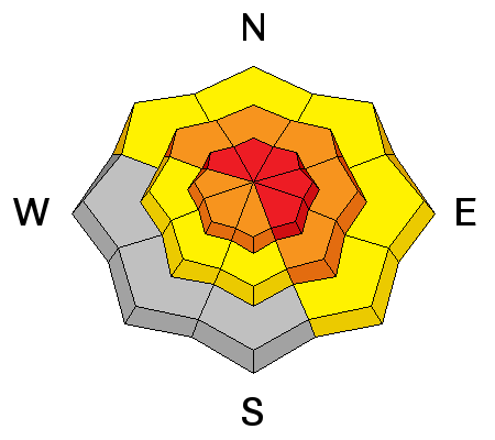
bottom line At mid and upper elevations, the avalanche danger is HIGH today. Both human triggered and natural avalanches are VERY LIKELY, especially on steep, wind drifted slopes facing the north half of the compass. Once triggered, today's avalanches have the potential to be deep and dangerous. Mid elevations have seen their fair share of wind and a CONSIDERABLE avalanche danger exists. Human triggered avalanches are PROBABLE on steep slopes with recent deposits of wind drifted snow. At low elevations a MODERATE danger exists for wet avalanches and human triggered slides are possible on steep, water soaked slopes.
|
 |
avalanche warning THE FOREST SERVICE UTAH AVALANCHE CENTER IN SALT LAKE CITY HAS ISSUED A BACKCOUNTRY AVALANCHE WARNING. * TIMING…IN EFFECT FROM 6 AM MST THIS MORNING TO 6 AM SATURDAY MORNING * AFFECTED AREA…FOR THE MOUNTAINS OF NORTHERN UTAH INCLUDING THE WASATCH RANGE...BEAR RIVER RANGE...AND WESTERN UINTA MOUNTAINS. * AVALANCHE DANGER…THE AVALANCHE DANGER FOR THE WARNING AREA IS HIGH AND WILL REMAIN HIGH THROUGH SATURDAY. * IMPACTS…HEAVY SNOW, MOUNTAIN RAIN AND STRONG WINDS HAVE CREATED WIDESPREAD AREAS OF UNSTABLE SNOW AT LOW, MID AND UPPER ELEVATIONS. BOTH HUMAN TRIGGERED AND NATURAL AVALANCHES ARE VERY LIKELY. STAY OFF OF AND OUT FROM UNDER SLOPES STEEPER THAN 30 DEGREES AND AVOID AVALANCHE RUNOUT ZONES. BACKCOUNTRY TRAVELERS SHOULD CONSULT WWW.UTAHAVALANCHECENTER.ORG OR CALL 1-888-999-4019 FOR MORE DETAILED INFORMATION. THIS WARNING DOES NOT APPLY TO SKI AREAS WHERE AVALANCHE HAZARD REDUCTION MEASURES ARE PERFORMED. |
 |
current conditions A tightly wound storm is making its way through the region this morning and the big news are the southerly winds. They've been averaging 30-40 mph with gusts in the 60's along the high ridges. 5" of dense, heavy snow fell overnight, with a rain/snow mix at lower elevations. Despite all the wind, you can still find soft creamy snow, but it'll have to be on very wind sheltered low and mid elevation slopes. Real time wind, snow, and temperatures for the Uinta's are found here. Recent observations are found here. |
 |
recent activity
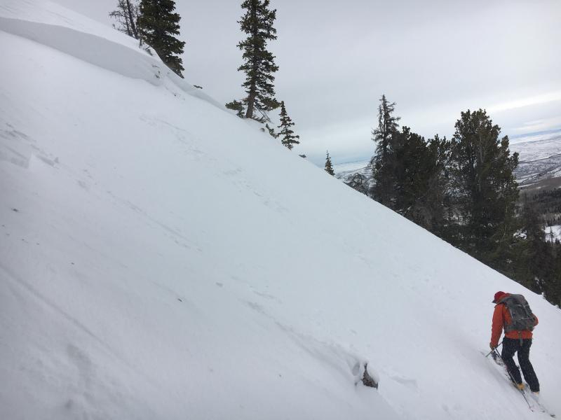
With a good thump, this fresh wind slab from yesterday was surprisingly connected, but didn't break into any old snow... which is good news. None-the-less, a slide this size could definitely ruin your day. With winds nuking all night, today's slabs are gonna break deeper and wider. A full list of recent avalanche activity is found here. |
| type | aspect/elevation | characteristics |
|---|

|
|
LIKELIHOOD
 LIKELY
UNLIKELY
SIZE
 LARGE
SMALL
TREND
 INCREASING DANGER
SAME
DECREASING DANGER
|
|
description
The most obvious avalanche problem today are fresh wind slabs. And with strong, variable winds on tap, they're gonna be all over the place and on all aspects today. Easy to identify by their fat, rounded appearance, today's wind drifts are gonna pack a punch and will break wider and deeper than you might expect. |
| type | aspect/elevation | characteristics |
|---|

|

|
LIKELIHOOD
 LIKELY
UNLIKELY
SIZE
 LARGE
SMALL
TREND
INCREASING DANGER
SAME
DECREASING DANGER
|
|
description
Found mostly on steep, rocky, mid and upper elevation slopes facing the north half of the compass, todays slabs may be harder to initiate, but once triggered, have the potential to break into weak layers now buried deep in our snowpack. And remember- any slide triggered that breaks into older snow near the ground, is going to be deep and dangerous. |
| type | aspect/elevation | characteristics |
|---|

|
|
LIKELIHOOD
LIKELY
UNLIKELY
SIZE
 LARGE
SMALL
TREND
 INCREASING DANGER
SAME
DECREASING DANGER
|
|
description
Rain on snow at lower elevations will turn our surface snow into a damp, gloppy mess. I think this is a short-lived problem, but before the storms' cold air arrives, you'll want to consider avoiding low elevation terrain traps like gullies and road cuts where debris can stack up very deeply. |
 |
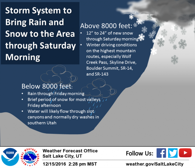
weather Warm, wet, and windy weather is slated for a good portion of the day and a moist southwest flow keeps snow levels high into early this afternoon. Snow continues this morning with temperatures hovering right around freezing. Southwest winds blow in the 40's and 50's along the ridges with gusts near 80 mph along the high peaks. A cold front slides across the region this afternoon with possible thunderstorms and snow lowering to the valley floor. A foot of snow is a good bet by early Saturday morning. A cold northerly flow develops Saturday ahead of a ridge for Sunday and early next week.
|
| general announcements Remember your information can save lives. If you see anything we should know about, please participate in the creation of our own community avalanche advisory by submitting snow and avalanche conditions. You can call me directly at 801-231-2170, email [email protected] The information in this advisory is from the US Forest Service which is solely responsible for its content. This advisory describes general avalanche conditions and local variations always occur. The information in this advisory expires 24 hours after the date and time posted, but will be updated by 7:00 AM on Saturday December 17th. |