25th Annual Black Diamond Fall Fundraising Party
Thursday, September 13; 6:00-10:00 PM; Black Diamond Parking Lot
25th Annual Black Diamond Fall Fundraising Party
Thursday, September 13; 6:00-10:00 PM; Black Diamond Parking Lot
| Advisory: Uintas Area Mountains | Issued by Craig Gordon for Sunday - December 11, 2016 - 3:16am |
|---|

|
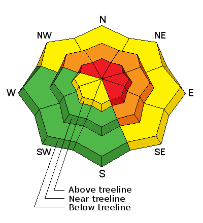
bottom line Above treeline in the wind zone, the avalanche danger is HIGH today. Human triggered avalanches are likely on steep, wind drifted slopes facing the north half of the compass and particularly in terrain with an easterly component to its aspect. Any slide triggered has the potential to be deep and dangerous. You'll find a CONSIDERABLE avalanche danger in mid elevation terrain facing the north half of the compass. Human triggered avalanches are probable on steep, wind drifted slopes. Even low elevation, shady slopes are getting in on the act and a MODERATE danger exists. Human triggered avalanches are possible on steep slopes with recent deposits of wind drifted snow. Low angle, wind sheltered slopes with nothing steep above or adjacent to where you're riding and most terrain facing the south half of the compass offers LOW avalanche danger.
|
 |
current conditions Well it took a while to develop, but wow... what a nice storm for the eastern front. Southwest winds raged along the ridges yesterday, averaging 30 mph with gusts to 50 mph along the high peaks. Snowfall rates picked up midmorning Saturday and it continued stomping until about midnight, delivering a pretty uniform 12 inches of snow with nearly an 1.5 of water across the range. That equates to heavier, denser snow than we usually see. Currently, under mostly cloudy skies and a lingering snow shower or two, west and northwest winds are blowing 15-20 mph and temperatures are in the mid to upper 20's. An active storm track delivered several feet of snow this week and average settled snow depths clock in at nearly 36". Real time wind, snow, and temperatures for the Uinta's are found here. Recent observations are found here.
Our main man Ted Scroggin was on the east side of range in Mill Creek yesterday, and reports that even the periphery terrain is starting to fill in. More on his travels are found here. |
 |
recent activity
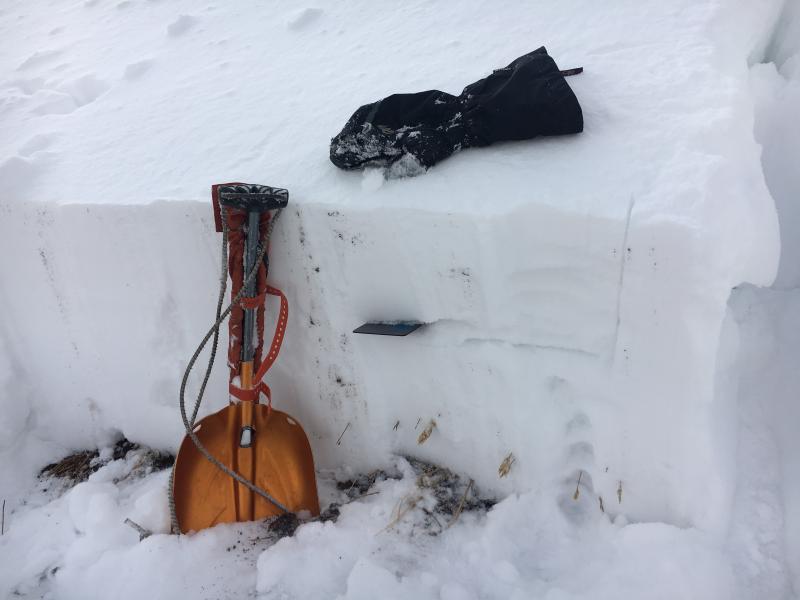
Ace observer Michael J popped out this wind drift late Saturday, on a steep section of Duke Bowl. At 6"-8" deep, it's not particularly deep, but sets the tone that fresh drifts were becoming sensitive to the additional weight of a person late in the day. More info from Michael is found here. |
| type | aspect/elevation | characteristics |
|---|

|

|
LIKELIHOOD
 LIKELY
UNLIKELY
SIZE
 LARGE
SMALL
TREND
 INCREASING DANGER
SAME
DECREASING DANGER
|
|
description
Today's avalanche dragon comes in two varieties.... the predictable and generally manageable, and the unpredictable and not so manageable. Sounds like going to a Vegas Craps table right? Problem is, with the second option the consequences greatly outweigh the reward. So here's the deal... we've got a weak layer now buried several feet deep in our midpack with strong, dense, cohesive snow resting on top of it. Yep, it's a strong snow on weak snow setup and you know that's a dangerous combination in our mountains. Found mostly on steep, rocky, mid and upper elevations facing the north half of the compass, todays slabs are going to be reactive to our additional weight and may break deeper and wider than you might expect. Remember- any slide triggered that breaks into older snow near the ground, will take you for a body bruising ride through stumps, rocks, or deadfall, instantly ruining your day. I think it'll be a little spooky out there today, but it doesn't mean we can't ride. It does mean we should avoid rolling the dice and simply stay off of and out from under steep, wind drifted terrain. We can have a blast today carving deep trenches in wide open meadows or on low angle slopes with no steep terrain hanging above us.
This is a good looking Uinta snowpack. In general, it's well-behaved and homogenous and we're not dealing with our usual weak snow issues near the ground. My snow crystal card is at the interface of this weeks cold snow which turned loose and sugary and is now preserved. Now, that same weak layer is buried under several storms worth of snow and todays avalanches can fail midpack, breaking wider and deeper than you might expect. |
| type | aspect/elevation | characteristics |
|---|

|

|
LIKELIHOOD
 LIKELY
UNLIKELY
SIZE
 LARGE
SMALL
TREND
 INCREASING DANGER
SAME
DECREASING DANGER
|
|
description
Fresh wind drifts sensitive to our additional weight are today's more obvious avalanche dragon. Easy to detect and easy to avoid, I'd steer clear of any fat, rounded piece of snow, especially if sounds or feels hollow like a drum. While found mostly on the leeward side of upper elevation ridges, I wouldn't be too surprised to find a few of these lurking in steep chutes and gullies at mid and lower elevations as well.
Easy to see when you hit the bare, rock littered ridge that the winds been blowing right to left. |
 |
weather The storm system that's homesteaded over the state since early in the week winds down today. As a result, we start to dry out and skies become partly cloudy. High temperatures reach into the upper 20's and overnight lows under clearing skies dip into the low teens. Westerly winds remain reasonable, blowing in the 20's and 30's along the high ridges. An active weather pattern ramps up again Tuesday afternoon through at least Saturday with significant snow accumulations possible, especially between Thursday afternoon and Friday evening.
|
| general announcements Remember your information can save lives. If you see anything we should know about, please participate in the creation of our own community avalanche advisory by submitting snow and avalanche conditions. You can call me directly at 801-231-2170, email [email protected] The information in this advisory is from the US Forest Service which is solely responsible for its content. This advisory describes general avalanche conditions and local variations always occur. The information in this advisory expires 24 hours after the date and time posted, but will be updated by 7:00 AM on Monday December 12th. |