25th Annual Black Diamond Fall Fundraising Party
Thursday, September 13; 6:00-10:00 PM; Black Diamond Parking Lot
25th Annual Black Diamond Fall Fundraising Party
Thursday, September 13; 6:00-10:00 PM; Black Diamond Parking Lot
| Advisory: Uintas Area Mountains | Issued by Craig Gordon for Friday - December 9, 2016 - 3:45am |
|---|


|
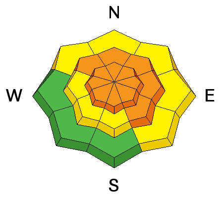
bottom line At mid and upper elevations, especially in the wind zone, the avalanche danger is CONSIDERABLE this morning. Human triggered avalanches are likely and natural avalanches possible on steep, wind drifted slopes, particularly in terrain with an easterly component to its aspect. With a good shot of snow and wind forecast the danger may rise to HIGH by days end. Even low elevation terrain is getting in on the act where you'll find a MODERATE danger on steep wind drifted slopes. Low angle slopes with nothing steep above or adjacent to where you're riding and low elevation south facing terrain offers LOW avalanche danger.
|
 |
avalanche warning WE HAVE ISSUED A BACKCOUNTRY AVALANCHE WARNING. * TIMING...IN EFFECT THROUGH 600 AM SATURDAY. * AFFECTED AREA...THE MOUNTAINS OF NORTHERN UTAH INCLUDING THE WASATCH RANGE...BEAR RIVER RANGE...AND THE WESTERN UINTA MOUNTAINS. * AVALANCHE DANGER...THE AVALANCHE DANGER WILL BECOME HIGH TODAY AND REMAIN ELEVATED THROUGH THE WEEKEND. * REASON/IMPACTS...DENSE HEAVY SNOW COMBINED WITH STRONG WINDS WILL CREATE WIDESPREAD AREAS OF UNSTABLE SNOW AT THE MID AND UPPER ELEVATIONS. BOTH HUMAN TRIGGERED AND NATURAL AVALANCHES ARE CERTAIN. STAY OFF OF AND OUT FROM UNDER SLOPES STEEPER THE 30 DEGREES. BACKCOUNTRY TRAVELERS SHOULD CONSULT WWW.UTAHAVALANCHECENTER.ORG OR CALL 1-888-999-4019 FOR MORE DETAILED INFORMATION. THIS WARNING DOES NOT APPLY TO SKI AREAS WHERE AVALANCHE HAZARD REDUCTION MEASURES ARE PERFORMED. |
 |
current conditions The first wave in a very active weather pattern brought raging west and southwest winds to the region overnight with hourly averages in the 30's and gusts to 60 mph along the high peaks. It's hard to say exactly how much much snow has fallen, but I'm estimating 4"-7" of dense, heavy, Sierra Cement. Under mostly cloudy skies it's still snowing. Yesterday at this time temperatures were in negative territory, this morning we're in the mid and upper 20's... yep, they've risen nearly 30 degrees in the past 24 hours. Real time wind, snow, and temperatures for the Uinta's are found here. Recent observations are found here. |
 |
recent activity Shallow wind drifts were becoming super sensitive by days end Thursday. |
| type | aspect/elevation | characteristics |
|---|

|
|
LIKELIHOOD
 LIKELY
UNLIKELY
SIZE
 LARGE
SMALL
TREND
 INCREASING DANGER
SAME
DECREASING DANGER
|
|
description
Our green light hazard and easy livin', low avalanche danger days are behind us. Avalanche conditions changed overnight and it's game on. This is the setup... strong winds, heavy, water-laden snow, and rising temperatures have created a dense, cohesive slab and this rests on all the nice light fluffy snow we're been riding this week. It's strong snow on weak snow and it's gonna be sensitive to our additional weight. No reason to get super technical here. Today's slabs are gonna break wider and deeper than you might expect. And remember- snow cover remains thin and any slide triggered today has the possibility of breaking into older snow near the ground, revealing stumps, rocks, or deadfall, resulting in a traumatic, and possibly season ending avalanche.
This is a good looking Uinta snowpack. In general, it's well-behaved and homogenous and we're not dealing with our usual weak, sugary snow near the ground. However, there's lots of pre-storm weak surface snow that's now preserved and buried under last night's storm. This combo created upside-down layering and you know strong snow on weak snow is a dangerous setup for our mountains. |
 |
weather A moist westerly flow results in periods of snow over the area through early Sunday. Snow should be on the light side today, but westerly winds ripping into the 40's and 50's will make their presence known. Temperatures don't vary much from where we're at this morning and we should hover in the mid to upper 20's for the next 24 hours. We might see an additional 3" of snow throughout the day, then snowfall rates are expected to increase tomorrow as additional moisture arrives. Precipitation tapers off Sunday, but a relatively active pattern persists through much of next week. |
| general announcements Remember your information can save lives. If you see anything we should know about, please participate in the creation of our own community avalanche advisory by submitting snow and avalanche conditions. You can call me directly at 801-231-2170, email [email protected] The information in this advisory is from the US Forest Service which is solely responsible for its content. This advisory describes general avalanche conditions and local variations always occur. The information in this advisory expires 24 hours after the date and time posted, but will be updated on Saturday December 10th. |