25th Annual Black Diamond Fall Fundraising Party
Thursday, September 13; 6:00-10:00 PM; Black Diamond Parking Lot
25th Annual Black Diamond Fall Fundraising Party
Thursday, September 13; 6:00-10:00 PM; Black Diamond Parking Lot
| Advisory: Uintas Area Mountains | Issued by Craig Gordon for Saturday - November 19, 2016 - 4:43am |
|---|
 |
special announcement Until the season really gets rolling, I'll update this information as storms start to develop or if conditions change rapidly. The next advisory update will be Monday, November 21st. In the meantime, while you're waiting for snow to stack up, please let us know what you're seeing. You can reach me at [email protected] Also, before life gets crazy busy, consider scheduling one of our free avalanche awareness presentations (contact me at [email protected]) or sign up for our ever-popular, sled specific Avy Awareness and Riding Skills Workshop. (Click here for more details) Whole foods event: Between now and Jan 15th: Donate to the Utah Avalanche Center by shopping at Whole Foods Market Utah! when you visit Whole Foods Market Trolley Square, Sugarhouse & Cottonwood Heights locations and bring in your re-usable bags, Whole Foods will donate a dime per bag to Utah Avalanche Center when the cashier asks if you want to “keep or donate” your bag credit and you say “DONATE". This is part of the Whole Foods “Your Change Creates Change” program, created to assist local non-profits! This is a fantastic opportunity for us to partner with Whole Foods and raise funding for our avalanche forecasting and education programs! We hope you’ll stop into Whole Foods Market, do some shopping and bring your reusable bags! The three participating locations are: Whole Foods Market Trolley Square - 544 S 700 E, Salt Lake City Whole Foods Market Sugarhouse - 1131 E. Wilmington Ave., Salt Lake City Whole Foods Market Cottonwood Heights - 6930 S. Highland Drive, Cottonwood Heights |
 |
current conditions Skies remained clear overnight and temperatures hovered in the mid 20's and low 30's. Along the high peaks southwest winds are ramping up with hourly averages in the 30's and gusts nearing 60 mph. It's not quite winter yet and in general, there's only about 6"-10" of snow on the ground. Real time wind, snow, and temperatures for the Uinta's are found here.
Tyler St. Jeor and I took advantage of the last day of balmy weather on Tuesday and worked on weather stations near Currant Creek Peak. As you can see, not much old snow even on the high elevation shady slopes on the south half of the range. |
 |
recent activity No new avalanche activity to report |
| type | aspect/elevation | characteristics |
|---|


|

|
LIKELIHOOD
 LIKELY
UNLIKELY
SIZE
 LARGE
SMALL
TREND
 INCREASING DANGER
SAME
DECREASING DANGER
|
|
description
The midweek storm delivered 6" of medium density snow, but there's hardly enough new snow to recreate on. The good news is.... nearly all the early season snow we received in late September either melted off or is patchy and not all that connected. Are you ready for more good news? I thought you were... and here goes. Thursday's storm snow fell on relatively dry, warm ground. What that means from an avalanche and snow stability perspective is that we're off to a benign start and there's very little, weak, sugary snow on the ground to contend with. Of course, that can all change and we'll keep you updated as the early season starts to unfold, but right now we're off to a good start. |
 |
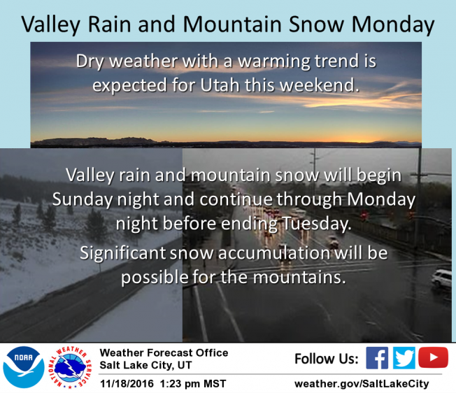
weather Encouraging news in the weather department and it looks like our dry, warm weather pattern changes starting tomorrow night. In the meantime, today we can expect high clouds, southwest winds gusting into the 50's and 60's along the high peaks, and temperatures topping out in the 40's. A thin veil of high clouds keeps overnight lows in the upper 20's. Look for increasing clouds Sunday with snow likely Monday into Monday night... 4"-8" of snow is a good bet by Tuesday morning. More snow on the way for the latter half of the week.
We're getting our weather stations back on line. For real-time snow depth, winds, and temperatures click here. |
| general announcements Remember your information can save lives. If you see anything we should know about, please participate in the creation of our own community avalanche advisory by submitting snow and avalanche conditions. You can call me directly at 801-231-2170, email [email protected] The information in this advisory is from the US Forest Service which is solely responsible for its content. This advisory describes general avalanche conditions and local variations always occur. The information in this advisory expires 24 hours after the date and time posted, but will be updated on Monday November 21st with general avalanche information. |