| Please join us at the 23rd annual Black Diamond Fall Fundraiser Party Thursday Sept 15. Tickets are on sale now here, at the Black Diamond store & at REI. Special bonus raffle for online ticket purchasers! |
| Please join us at the 23rd annual Black Diamond Fall Fundraiser Party Thursday Sept 15. Tickets are on sale now here, at the Black Diamond store & at REI. Special bonus raffle for online ticket purchasers! |
| Advisory: Uintas Area Mountains | Issued by Trent Meisenheimer for Sunday - April 3, 2016 - 5:51am |
|---|


|
bottom line As the day heats up, expect the avalanche danger to rise to MODERATE. Human triggered wet slides and sluffs become possible on all steep sunny slopes, especially during the heat of the day.
|
 |
current conditions Skies remained clear and cold overnight, allowing for a good refreeze. Mountain temperatures are currently in the 20's at 10,000' feet in elevation. Winds continue to be light, blowing from the northwest 15-20 mph with the occasional gust to 25 mph. Dry cold powder and excellent riding conditions remain on north aspects at upper elevations. Uinta weather station network info is found here. Trip reports and observations are found here.
|
 |
recent activity No new avalanche activity to report. Recent avalanche observations are found here See or trigger an avalanche? Shooting cracks? Hear a collapse? It's simple. Go here to fill out an observation.
|
| type | aspect/elevation | characteristics |
|---|

|

|
LIKELIHOOD
 LIKELY
UNLIKELY
SIZE
 LARGE
SMALL
TREND
 INCREASING DANGER
SAME
DECREASING DANGER
|
|
description
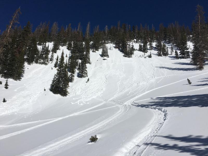
With clear skies and cold temperatures the avalanche danger is generally LOW this morning. However, the heat is gonna get cranked up today and as such, wet avalanches are the primary concern. Fortunately, wet slides and sluffs are easy to manage. If you're feeling like an ant under a magnifying glass... well, so is the snowpack. Remember- the sun is high in the sky, it's intense, and it's affecting all aspects and elevations. As the surface snow heats up or if you find yourself sinking into damp, manky snow, simply get off of and out from under steep sun-exposed slopes. Also, you'll want to avoid terrain traps like gullies and road cuts where cement-like, bone snapping debris can pile up very deeply.
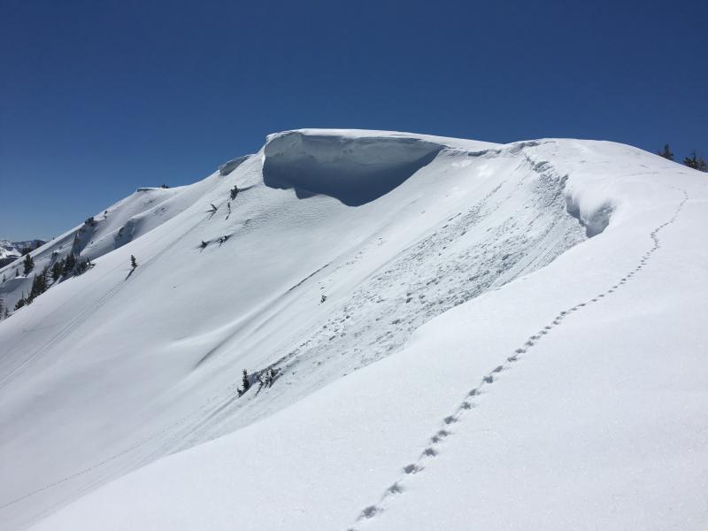
Picture of wet avalanche activity from late in the day yesterday. Cornices have grown large and are starting to sag under the intense sun rays. These giant blocks of heavy snow are just waiting to break free and come crashing down. Today you will want to avoid riding below these massive chunks of snow. If you're topping out on ridge line always make sure you give cornices a wide berth. They tend to catch us off guard breaking further back than we might expect.
|
 |
weather Sunny skies, light winds, and temperatures climbing into the mid and upper 40's. Overnight lows dip to near freezing. A weak storm clips northern Utah late tonight with another system slated for Monday. Neither look like they'll produce much in the way of snow.
|
| general announcements Remember your information can save lives. If you see anything we should know about, please participate in the creation of our own community avalanche advisory by submitting snow and avalanche conditions. You can call me directly at 801-231-2170, email [email protected], or email by clicking HERE If Craig is unavailable you can reach his partner Trent at 801-455-7239, email [email protected] This is a great time of year to schedule a free avalanche awareness presentation for your group or club. You can contact me at 801-231-2170 or email [email protected]. To register for the first in our series of on-the-snow sled specific classes you can register here. The information in this advisory is from the US Forest Service which is solely responsible for its content. This advisory describes general avalanche conditions and local variations always occur. The information in this advisory expires 24 hours after the date and time posted, but will be updated by 7:00 AM on Monday, April 4th.
|