| Please join us at the 23rd annual Black Diamond Fall Fundraiser Party Thursday Sept 15. Tickets are on sale now here, at the Black Diamond store & at REI. Special bonus raffle for online ticket purchasers! |
| Please join us at the 23rd annual Black Diamond Fall Fundraiser Party Thursday Sept 15. Tickets are on sale now here, at the Black Diamond store & at REI. Special bonus raffle for online ticket purchasers! |
| Advisory: Uintas Area Mountains | Issued by Craig Gordon for Friday - April 1, 2016 - 4:18am |
|---|

|
bottom line While not widespread and making up a small portion of the terrain available to ride in today, a MODERATE avalanche danger exists and human triggered avalanches are possible on all steep wind drifted slopes at and above treeline in the wind zone. Out of the wind the avalanche danger is generally LOW.
|
 |
special announcement Check out the Adventure and Gear Expo on April 8 & 9 at the Southtowne Expo Center. Use the code GOUAC to get a $2 discount on entrance tickets and the Adventure and Gear Expo will donate $2 to the UAC. http://www.adventuregearfest.com/ Spring powder special! We have reduced the price of donated Snowbasin lift tickets to $50 and Sundance tickets to $35, about half of window price. Take advantage of fresh powder on a fat snowpack and benefit the Utah Avalanche Center at the same time. Every penny spent on these donated tickets benefits the Utah Avalanche Center. |
 |
current conditions A nice coat of white paint blanketed the peaks as wrap around moisture delivered 4" of medium density snow to the high country yesterday. Skies began clearing overnight and temperatures are in the mid teens this morning. Since early yesterday morning, north and northeast winds remained steady along the high elevation ridges, blowing 15-25 mph, though a few high peaks saw gusts in the 40's. Low elevation terrain took on some heat yesterday, but gain some vertical, swing over to north facing, wind sheltered slopes and you'll be rewarded with cold, dry snow. Uinta weather station network info is found here. Trip reports and observations are found here.
|
 |
recent activity
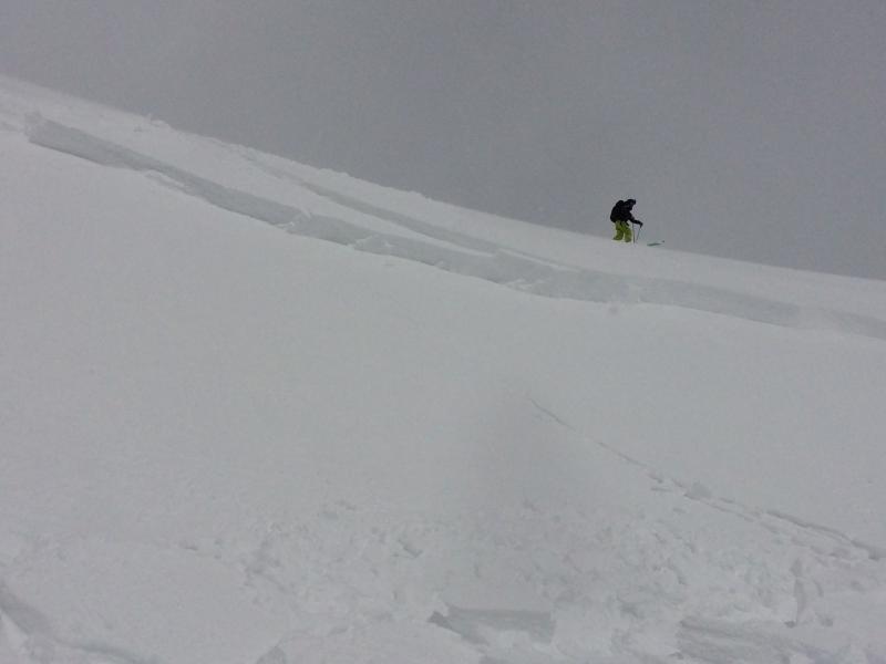
Here's a great ob from Chris Brown in Upper Weber Canyon yesterday- "Found a 3-3.5' deep avalanche in a good fetch on SE aspect. Very sensitive, popped out on ski cut, much deeper than expected. Initiated as a 12" soft windslab and instantly steped down an additional 2-2.5', about 175-200' wide. Ran about 200-300' and stopped as slope angle decreased." More here. (C.Brown photo) Recent avalanche observations are found here See or trigger an avalanche? Shooting cracks? Hear a collapse? It's simple. Go here to fill out an observation.
|
| type | aspect/elevation | characteristics |
|---|

|

|
LIKELIHOOD
 LIKELY
UNLIKELY
SIZE
 LARGE
SMALL
TREND
 INCREASING DANGER
SAME
DECREASING DANGER
|
|
description
Yesterday's storm produced a little more snow and wind than I expected and as such, wind drifts were a bit touchy. Fortunately, spring storm snow tends to settle out and stabilize rapidly and I think that's going to be the case with the last round of storminess. That's not to say you couldn't find a rogue slab or two sensitive to your additional weight. As a matter of fact, if you went avalanche hunting I bet you can still trigger a drift that has the potential to catch you off guard and maybe even boss you around a bit. While more the exception than the rule, the most likely terrain to encounter these conditions are steep, upper elevation, leeward slopes, especially those in the wind zone above treeline.
|
 |
weather Northeast winds blowing in the 20's and 30's, continue for the next couple of hours, but drop off this morning as high pressure starts to build in from the west. Expect mostly sunny skies with temperatures climbing into the mid and upper 30's. Under clear skies, overnight lows dip into the mid 20's. High pressure brings warm and dry conditions through the weekend.
|
| general announcements Remember your information can save lives. If you see anything we should know about, please participate in the creation of our own community avalanche advisory by submitting snow and avalanche conditions. You can call me directly at 801-231-2170, email [email protected], or email by clicking HERE If Craig is unavailable you can reach his partner Trent at 801-455-7239, email [email protected] This is a great time of year to schedule a free avalanche awareness presentation for your group or club. You can contact me at 801-231-2170 or email [email protected]. To register for the first in our series of on-the-snow sled specific classes you can register here. The information in this advisory is from the US Forest Service which is solely responsible for its content. This advisory describes general avalanche conditions and local variations always occur. The information in this advisory expires 24 hours after the date and time posted, but will be updated by 7:00 AM on Saturday, April 2nd.
|