| Please join us at the 23rd annual Black Diamond Fall Fundraiser Party Thursday Sept 15. Tickets are on sale now here, at the Black Diamond store & at REI. Special bonus raffle for online ticket purchasers! |
| Please join us at the 23rd annual Black Diamond Fall Fundraiser Party Thursday Sept 15. Tickets are on sale now here, at the Black Diamond store & at REI. Special bonus raffle for online ticket purchasers! |
| Advisory: Uintas Area Mountains | Issued by Craig Gordon for Wednesday - March 30, 2016 - 4:26am |
|---|


|
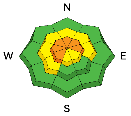
bottom line While not widespread and making up a small portion of the terrain available to ride in today, pockets of CONSIDERABLE avalanche danger exist and human triggered avalanches are likely on all steep wind drifted slopes at and above treeline in the wind zone. Mid elevation terrain offers MODERATE avalanche danger and human triggered avalanches are possible on steep slopes with recent deposits of wind drifted snow. Out of the wind the avalanche danger is generally LOW.
|
 |
special announcement Check out the Adventure and Gear Expo on April 8 & 9 at the Southtowne Expo Center. Use the code GOUAC to get a $2 discount on entrance tickets and the Adventure and Gear Expo will donate $2 to the UAC. http://www.adventuregearfest.com/ Spring powder special! We have reduced the price of donated Snowbasin lift tickets to $50 and Sundance tickets to $35, about half of window price. Take advantage of fresh powder on a fat snowpack and benefit the Utah Avalanche Center at the same time. Every penny spent on these donated tickets benefits the Utah Avalanche Center. |
 |
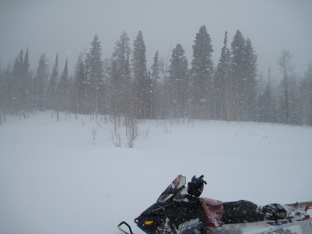
current conditions Wow... what a good storm for the eastern front! Storm totals on the North Slope are close to 18" with about 1.5" of water. Winds mellowed significantly yesterday afternoon and remained light overnight, blowing just 5-10 mph even along the highest peaks. Under partly cloudy skies this morning, temperatures are in the teens. On a go-anywhere base, mid elevation, wind sheltered terrain is gonna be the ticket today.
Ted found deep, cold snow in the Whitney Basin yesterday. More on his travels here. (Scroggin photo) Uinta weather station network info is found here. Trip reports and observations are found here.
|
 |
recent activity
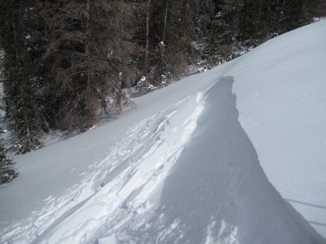
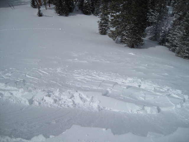
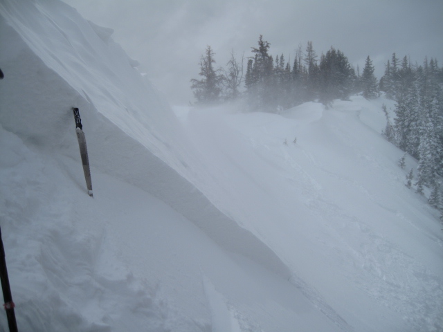
Soft slabs along the leeward side of upper elevation ridges were super tender and very reactive yesterday. Recent avalanche observations are found here See or trigger an avalanche? Shooting cracks? Hear a collapse? It's simple. Go here to fill out an observation.
|
| type | aspect/elevation | characteristics |
|---|

|
|
LIKELIHOOD
 LIKELY
UNLIKELY
SIZE
 LARGE
SMALL
TREND
 INCREASING DANGER
SAME
DECREASING DANGER
|
|
description
I'm thinking yesterday's tender, fresh drifts probably relaxed somewhat overnight and won't be nearly as sensitive today. However, I bet there's still a pocket or two lurking on steep, leeward slopes in the wind zone. Today's drifts are gonna be a little harder to detect because they're covered over with fresh snow, but a safe bet is to carefully evaluate steep, wind drifted slopes and avoid any fat rounded pillows of snow or cross-loaded chutes and gullies. Once triggered, today's slides can easily boss you around and have the potential to be an instant buzz-kill. By now you know the drill- look for clues to unstable snow like shooting cracks around your skis, board, or sled and of course the most obvious... recent avalanche activity on the same types of slopes you wanna ride on.
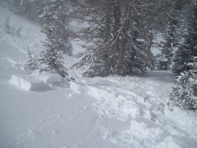
Triggering even a small slide and getting slammed into a group of trees can definately put a damper on the day. (Scroggin photo)
|
 |
weather A few snow showers drift through the region today, but in general we're drying out. Winds should shift to the northeast during the day, but will remain rather light, blowing less than 20 mph. High temperatures rise into the upper 20's and overnight lows dip into the teens. High pressure builds for the latter half of the work week.
|
| general announcements Remember your information can save lives. If you see anything we should know about, please participate in the creation of our own community avalanche advisory by submitting snow and avalanche conditions. You can call me directly at 801-231-2170, email [email protected], or email by clicking HERE If Craig is unavailable you can reach his partner Trent at 801-455-7239, email [email protected] This is a great time of year to schedule a free avalanche awareness presentation for your group or club. You can contact me at 801-231-2170 or email [email protected]. To register for the first in our series of on-the-snow sled specific classes you can register here. The information in this advisory is from the US Forest Service which is solely responsible for its content. This advisory describes general avalanche conditions and local variations always occur. The information in this advisory expires 24 hours after the date and time posted, but will be updated by 7:00 AM on Thursday, March 31st.
|