| Please join us at the 23rd annual Black Diamond Fall Fundraiser Party Thursday Sept 15. Tickets are on sale now here, at the Black Diamond store & at REI. Special bonus raffle for online ticket purchasers! |
| Please join us at the 23rd annual Black Diamond Fall Fundraiser Party Thursday Sept 15. Tickets are on sale now here, at the Black Diamond store & at REI. Special bonus raffle for online ticket purchasers! |
| Advisory: Uintas Area Mountains | Issued by Craig Gordon for Saturday - March 26, 2016 - 4:36am |
|---|

|
bottom line In the wind zone, at and above treeline, pockets of MODERATE avalanche danger exist and human triggered avalanches are possible on steep, wind drifted slopes. Out of the wind the avalanche danger is generally LOW.
|
 |
current conditions A weak cold front slid through the region late last night, delivering a couple inches of light density snow and dropping temperatures into the single digits. Winds are light, generally out of the northeast, and blowing just 5-15 mph even along the highest peaks. Riding and turning conditions are quite good, especially on mid elevation shady slopes.
Tyler St. Jeor was riding out of Soapstone yesterday and found deep, cold, in your face pow. (St.Jeor photo) Uinta weather station network info is found here. Trip reports and observations are found here.
|
 |
recent activity No recent avalanche activity to report. Recent avalanche observations are found here See or trigger an avalanche? Shooting cracks? Hear a collapse? It's simple. Go here to fill out an observation.
|
| type | aspect/elevation | characteristics |
|---|

|
|
LIKELIHOOD
 LIKELY
UNLIKELY
SIZE
 LARGE
SMALL
TREND
 INCREASING DANGER
SAME
DECREASING DANGER
|
|
description
In general the snowpack is well-behaved, predictable, and comfortable in its own skin. In the short term, light winds and the couple inches of snow that stacked up yesterday and overnight isn't going to change that equation. Of course, the Uinta's are a big range and I bet if you went looking for a shallow slab you could find one sensitive to your additional weight, especially if your travels take you to steep, upper elevation, leeward terrain. While today's drifts are pockety and manageable in depth and width, remember... even a small slide can take you for a fast, body-bruising ride, especially in steep, committing terrain.
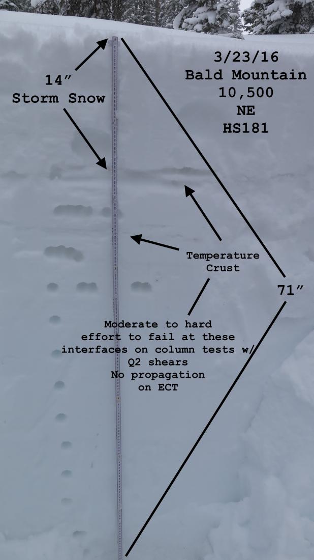
Welcome back JG.... we've missed your detailed pit profiles! More on JG's travels are found here.
|
 |
weather Today we can expect mostly cloudy skies and colder temperatures with light snow tapering off later this morning. We might see a slight bump in wind speeds early this morning, but winds rapidly diminish and skies start to clear by lunchtime. High temperatures climb into the mid 20's with overnight lows dipping into the teens. Sunny skies and warmer temperatures are on tap for Sunday. Monday is a day of transition as south winds ramp up ahead of a prolonged period of cold, unsettled weather slated for Tuesday and Wednesday.
|
| general announcements Remember your information can save lives. If you see anything we should know about, please participate in the creation of our own community avalanche advisory by submitting snow and avalanche conditions. You can call me directly at 801-231-2170, email [email protected], or email by clicking HERE If Craig is unavailable you can reach his partner Trent at 801-455-7239, email [email protected] This is a great time of year to schedule a free avalanche awareness presentation for your group or club. You can contact me at 801-231-2170 or email [email protected]. To register for the first in our series of on-the-snow sled specific classes you can register here. The information in this advisory is from the US Forest Service which is solely responsible for its content. This advisory describes general avalanche conditions and local variations always occur. The information in this advisory expires 24 hours after the date and time posted, but will be updated by 7:00 AM on Sunday, March 27th.
|