| Please join us at the 23rd annual Black Diamond Fall Fundraiser Party Thursday Sept 15. Tickets are on sale now here, at the Black Diamond store & at REI. Special bonus raffle for online ticket purchasers! |
| Please join us at the 23rd annual Black Diamond Fall Fundraiser Party Thursday Sept 15. Tickets are on sale now here, at the Black Diamond store & at REI. Special bonus raffle for online ticket purchasers! |
| Advisory: Uintas Area Mountains | Issued by Craig Gordon for Tuesday - March 8, 2016 - 3:57am |
|---|

|
bottom line While the avalanche danger is generally LOW, pockets of MODERATE avalanche danger exist, especially on steep, wind drifted slopes and particularly in terrain with a thin, weak snowpack. While it's becoming more the exception than the rule, any avalanche that fails on weak, sugary snow near the ground, has the potential to break deeper and wider than you might expect.
|
 |
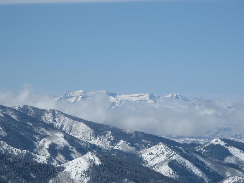
current conditions Skies cleared last night and temperatures crashed into the low and mid teens where they sit early this morning. Yesterday's northeast winds blew in the 20's and 30's, but died down around 6:00 last night and are currently light and variable, blowing just 5-15 mph even along the highest peaks. Sunday night's storm went a long way helping to reset the mountain canvas while adding a bit of cushion to the old, hard snow surfaces. While the lower elevation sunny slopes took on some heat and are crusted this morning, swing over to the other side of the compass and you'll still find soft, settled powder.
Beautimous- amazingly wonderfulously prettifulish in a beautiful epicly wowish way. Once again, Urban Dictionary nails the sights and sounds of the western Uinta's as storm clouds shroud the peaks of the Wasatch back.
Uinta weather station network info is found here. Trip reports and observations are found here.
|
 |
recent activity No new avalanche activity to report. Recent avalanche observations are found here See or trigger an avalanche? Shooting cracks? Hear a collapse? It's simple. Go here to fill out an observation.
|
| type | aspect/elevation | characteristics |
|---|

|
|
LIKELIHOOD
 LIKELY
UNLIKELY
SIZE
 LARGE
SMALL
TREND
 INCREASING DANGER
SAME
DECREASING DANGER
|
|
description
Winds were all over the map during and after Sunday night's storm, but suprisingly Trent and I found the fresh drifts rather well behaved and predictable. Of course, the Uinta's are a huge range and our travels yesterday revealed just a postage size snapshot of the big picture. That said, it's not full-on green light, send everything in sight, ride it if it's white, avalanche danger... but it's getting closer, especially in wind sheltered terrain. However, if you're travels take you into steep, commiting terrain, in the wind zone look for and avoid any fat, rounded piece of snow, especially if it feels or sounds hollow like a drum. In addition to fresh drifts, a rogue slab breaking into weak snow near the ground isn't out of the question and our usual suspects come to mind... steep, rocky terrain with a shallow, weak snowpack. Any slide that breaks to weak snow near the ground has the potential to quickly ruin your day.
|
 |
weather It'll be a beautiful day in the mountains with mostly sunny skies, light winds, and temperatures rising into the low to mid 30's. Clouds increase late in the day and westerly winds bump into the 20's as a weak system slides through the region tonight and early Wednesday. Not expecting much snow out of the storm before high pressure returns for the last half of the work week. A warm southwest flow develops Thursday afternoon and becomes stronger on Friday. A storm system could cross the area Friday night into Saturday but there remains considerable uncertainty on the track and intensity of this storm.
|
| general announcements Remember your information can save lives. If you see anything we should know about, please participate in the creation of our own community avalanche advisory by submitting snow and avalanche conditions. You can call me directly at 801-231-2170, email [email protected], or email by clicking HERE If Craig is unavailable you can reach his partner Trent at 801-455-7239, email [email protected] This is a great time of year to schedule a free avalanche awareness presentation for your group or club. You can contact me at 801-231-2170 or email [email protected]. To register for the first in our series of on-the-snow sled specific classes you can register here. The information in this advisory is from the US Forest Service which is solely responsible for its content. This advisory describes general avalanche conditions and local variations always occur. The information in this advisory expires 24 hours after the date and time posted, but will be updated by 7:00 AM on Wednesday, March 9th.
|