| Please join us at the 23rd annual Black Diamond Fall Fundraiser Party Thursday Sept 15. Tickets are on sale now here, at the Black Diamond store & at REI. Special bonus raffle for online ticket purchasers! |
| Please join us at the 23rd annual Black Diamond Fall Fundraiser Party Thursday Sept 15. Tickets are on sale now here, at the Black Diamond store & at REI. Special bonus raffle for online ticket purchasers! |
| Advisory: Uintas Area Mountains | Issued by Trent Meisenheimer for Sunday - March 6, 2016 - 4:58am |
|---|

|
bottom line We have a rising avalanche danger today - this morning the avalanche danger will be mostly LOW. As the storm arrives a MODERATE avalanche danger will exits on steep, upper elevation, leeward slopes today. Simply avoid steep upper elevation slopes, and be suspicious of any steep terrain with recent deposits of wind drifted snow. Remember- any avalanche that fails on weak, sugary snow near the ground, has the potential to break deeper and wider than you might expect.
|
 |
current conditions Skies are mostly cloudy this morning, as a fast moving storm approaches the state. It remains to be mild this morning with 10,000' temperatures in the upper 20's. Southerly winds have picked up and are blowing 30 mph gusting into the mid to upper 40's along the high terrain. South facing slopes will be crusted this morning as the temperature continues to drop. High elevation northerly terrain still offers some shallow soft snow. Picture of Bald Mountain off the Mirror Lake Hwy taken yeasterday.
Uinta weather station network info is found here. Trip reports and observations are found here.
|
 |
recent activity No new avalanche activity to report. Recent avalanche observations are found here See or trigger an avalanche? Shooting cracks? Hear a collapse? It's simple. Go here to fill out an observation.
|
| type | aspect/elevation | characteristics |
|---|

|
|
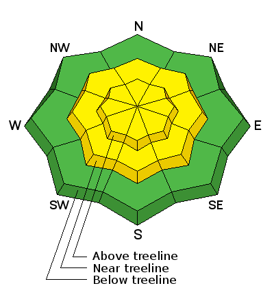
LIKELIHOOD
 LIKELY
UNLIKELY
SIZE
 LARGE
SMALL
TREND
 INCREASING DANGER
SAME
DECREASING DANGER
|
|
description
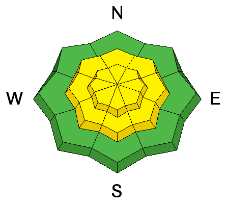
Expect a rising avalanche danger today as a cold front moves across the Uinta mountains. Winds are currently blowing 30 mph out of the south-west gusting into the 40's along the high terrain. As the cold front arrives the wind direction will shift from the south-west to north-west around 11:00am this morning. By late afternoon there will be enough new snow for the wind to grab and start loading the leeward slopes (opposite side of the mountain). This will create sensitive wind slabs on all upper elevation slopes around the compass today. Remember - even a small slide can knock you off your feet or sled and take you for a fast, body bruising ride into trees or over a cliff band. The bottom line: Simply avoid steep upper elevation slopes today, and be suspicious of any steep slope with recent deposits of wind drifted snow.
|
| type | aspect/elevation | characteristics |
|---|

|
|
LIKELIHOOD
 LIKELY
UNLIKELY
SIZE
 LARGE
SMALL
TREND
INCREASING DANGER
SAME
DECREASING DANGER
|
|
description
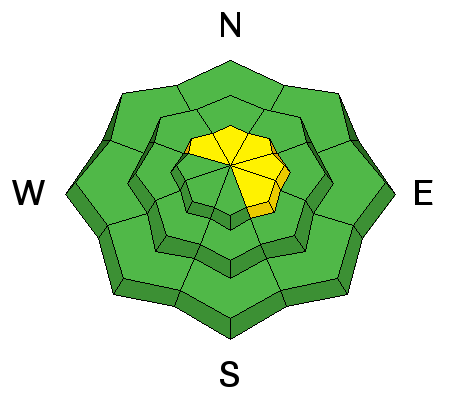
It has been two weeks since the last reported slab avalanche. However, the fact is we still have many places with a very poor snowpack structure - meaning we have weak snow with stronger more dense snow sitting on top (bad setup). What we have been lacking is the additional weight of new snow (slab). Today we are expecting new snow and wind which could make this problem become more active. Remember- persistent slabs have the potential to break deeper and wider than you might expect. Steep, rocky terrain, facing the north half of the compass and particularly slopes that avalanched near the ground earlier this season should be considered suspect and avoided. Steep, rocky, thin, and weak... this is the kind of terrain where you could still trigger a slide that breaks to weak snow near the ground today. (Scroggin photo)
|
 |
weather Winds continue to blow into the 30's and 40's out of the south-west this morning, before switching to the north-west as the cold front arrives. Wind and Heavy snow is expected and there is a chance for lightning this afternoon. Snow will continue for much of the day and the north-west winds should decrease after the frontal passage. Temperatures will drop and it will finally feel like winter again. Hopefully by Monday morning we will have 5-10'' of new snow. The storm exits the area on Monday.
|
| general announcements Remember your information can save lives. If you see anything we should know about, please participate in the creation of our own community avalanche advisory by submitting snow and avalanche conditions. You can call me directly at 801-231-2170, email [email protected], or email by clicking HERE If Craig is unavailable you can reach his partner Trent at 801-455-7239, email [email protected] This is a great time of year to schedule a free avalanche awareness presentation for your group or club. You can contact me at 801-231-2170 or email [email protected]. To register for the first in our series of on-the-snow sled specific classes you can register here. The information in this advisory is from the US Forest Service which is solely responsible for its content. This advisory describes general avalanche conditions and local variations always occur. The information in this advisory expires 24 hours after the date and time posted, but will be updated by 7:00 AM on Monday, March 7th.
|


