| Please join us at the 23rd annual Black Diamond Fall Fundraiser Party Thursday Sept 15. Tickets are on sale now here, at the Black Diamond store & at REI. Special bonus raffle for online ticket purchasers! |
| Please join us at the 23rd annual Black Diamond Fall Fundraiser Party Thursday Sept 15. Tickets are on sale now here, at the Black Diamond store & at REI. Special bonus raffle for online ticket purchasers! |
| Advisory: Uintas Area Mountains | Issued by Craig Gordon for Tuesday - March 1, 2016 - 4:28am |
|---|

|
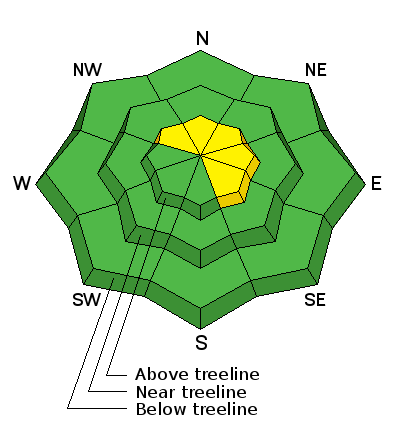
bottom line While the avalanche danger is generally LOW, pockets of MODERATE avalanche danger exist on steep, upper elevation, leeward slopes, especially those facing the north half of the compass. Remember- any avalanche that fails on weak, sugary snow near the ground, has the potential to break deeper and wider than you might expect.
|
 |
special announcement The Utah Avalanche Center greatly values in longtime partnership with our world-class resorts and is blowing out the remaining donated lift tickets from Alta, Snowbird, Snowbasin, Sundance, and Nordic Valley with reduced prices. Every penny you spend and turn you make benefits the Utah Avalanche Center. Check out our Garage Sale! Chock full of sweet backcountry gear - you can find the goods on our Facebook page here. |
 |
current conditions A few clouds drifted into the region early this morning, ahead of a warm front that's sliding through the area as I type. West and southwest winds cranked in the 40's and 50's on Monday, though they've mellowed somewhat and are currently blowing in the 20's and 30's. Temperatures are in the upper teens and low 20's. Snow surface conditions run the gamut of supportable crusts on south facing terrain to patches of soft, settled powder on wind sheltered shady slopes. Uinta weather station network info is found here. Trip reports and observations are found here.
|
 |
recent activity No new avalanche activity to report. Recent avalanche observations are found here See or trigger an avalanche? Shooting cracks? Hear a collapse? It's simple. Go here to fill out an observation.
|
| type | aspect/elevation | characteristics |
|---|

|
|
LIKELIHOOD
 LIKELY
UNLIKELY
SIZE
 LARGE
SMALL
TREND
 INCREASING DANGER
SAME
DECREASING DANGER
|
|
description
With a little loose snow to work with, fresh wind drifts are gonna be today's most obvious and certainly most manageable avalanche problem. Found on steep, leeward slopes in the wind zone above treeline, today's shallow slabs are easy to detect by their fat, rounded appearance and easy to avoid. Simply lose a little elevation and you'll lose the problem. Less predictable, is any slide that fails on weak, sugary snow near the ground, or what we call persistent slabs. Remember- persistent slabs have the potential to break deeper and wider than you might expect. Steep, rocky terrain facing the north half of the compass and particularly slopes that avalanched near the ground earlier this season should be considered suspect. Sled triggered avalanche in Gold Hill Basin, that Ted discovered from a week ago. Breaking 150' wide and failing on weak snow near the ground, check out Ted's great write-up here and video below. GOPR0029 from ted scroggin on Vimeo. |
 |
weather A warm front crosses the area this morning bringing a few clouds and a slight chance of a flurry or two. Westerly winds remain a nuisance for the morning, blowing 30-50 mph along the ridges, but should taper off as the day wares on. High temperatures climb into the upper 30's with overnight lows in the 20's A weak cold front crosses the area late tonight into Wednesday morning bringing another small chance for light snow. Not much going on until Sunday when it looks like we'll see a change in the pattern towards wet and unsettled weather for next week.... stay tuned.
|
| general announcements Remember your information can save lives. If you see anything we should know about, please participate in the creation of our own community avalanche advisory by submitting snow and avalanche conditions. You can call me directly at 801-231-2170, email [email protected], or email by clicking HERE If Craig is unavailable you can reach his partner Trent at 801-455-7239, email [email protected] This is a great time of year to schedule a free avalanche awareness presentation for your group or club. You can contact me at 801-231-2170 or email [email protected]. To register for the first in our series of on-the-snow sled specific classes you can register here. The information in this advisory is from the US Forest Service which is solely responsible for its content. This advisory describes general avalanche conditions and local variations always occur. The information in this advisory expires 24 hours after the date and time posted, but will be updated by 7:00 AM on Wednesday, March 2nd.
|


