| Please join us at the 23rd annual Black Diamond Fall Fundraiser Party Thursday Sept 15. Tickets are on sale now here, at the Black Diamond store & at REI. Special bonus raffle for online ticket purchasers! |
| Please join us at the 23rd annual Black Diamond Fall Fundraiser Party Thursday Sept 15. Tickets are on sale now here, at the Black Diamond store & at REI. Special bonus raffle for online ticket purchasers! |
| Advisory: Uintas Area Mountains | Issued by Trent Meisenheimer for Friday - February 12, 2016 - 5:17am |
|---|

|
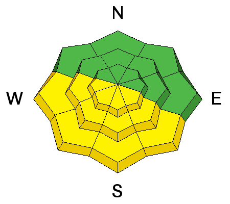
bottom line At and above treeline, a MODERATE avalanche danger exists and human triggered avalanches are possible on steep, wind drifted slopes. Any avalanche that breaks to weak, sugary snow near the ground has the potential to be deep and dangerous. Steep sunny slopes will become damp and soggy and the danger of wet slides and sluffs increases to MODERATE with daytime heating. Wind and sun sheltered terrain that is under 30 degrees in slope steepness is the ticket for finding both LOW avalanche danger and great riding conditions.
|
 |
special announcement
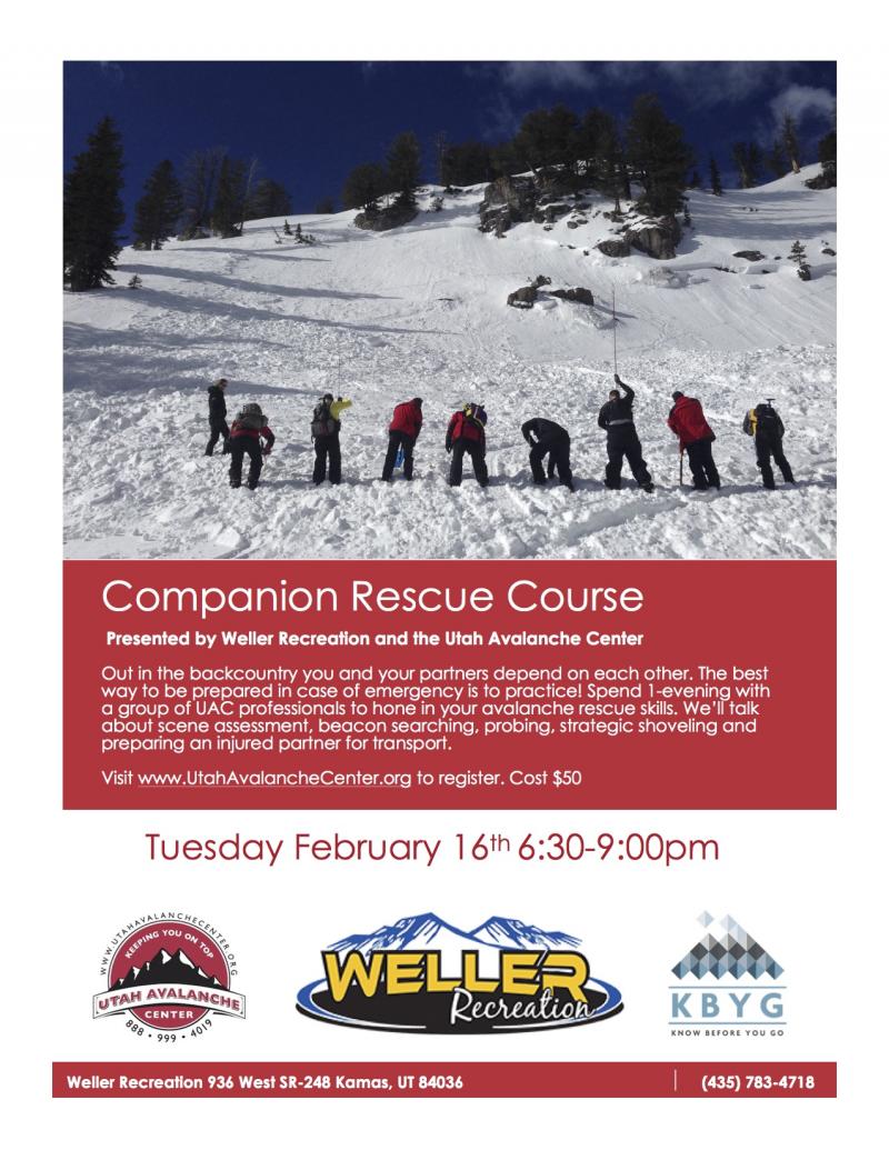
Join us next Tuesday for a companion rescue workshop hosted by our good friends at Weller Recreation. Should be a great time - Click here for more details and to register.
|
 |
current conditions We have clear skies this morning - 9,000' (trailhead) temperatures hovering in the low 30's and at 10,000' temps are in the low 30's as well. The strong inversion continues. Winds have switched from the northwest and are now blowing out of the southwest 10-15mph with the occasional gust to 25mph. The snow surface has taken a beating from the sun, but you can still find soft powder on the shady (north) side of the compass. Left photo - showing the soft settled powder on the north facing terrain. Right photo - sun crust that is found on all other aspects. (Photo: JG)
Trip reports and observations are found here.
|
 |
recent activity No new avalanche activity has been reported from the backcountry. Recent avalanche observations are found here See or trigger an avalanche? Shooting cracks? Hear a collapse? It's simple. Go here to fill out an observation.
|
| type | aspect/elevation | characteristics |
|---|

|
|
LIKELIHOOD
 LIKELY
UNLIKELY
SIZE
 LARGE
SMALL
TREND
 INCREASING DANGER
SAME
DECREASING DANGER
|
|
description
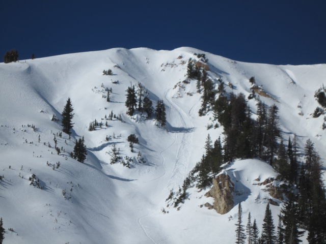
Another round of strong sunshine and warm temperatures are on tap for the Uinta's. Overnight temperatures did not drop below freezing and the snow surface on the south half of the compass will become damp and soggy very quick today. During the heat of the day simply get off of an out from under steep sunny slopes and avoid terrain traps like gullies and road cuts where avalanche debris can pile up very deeply. Ted Scroggin out doing some field work yesterday snapped a great couple photos of these point release (loose snow) avalanches.
|
| type | aspect/elevation | characteristics |
|---|

|

|
LIKELIHOOD
 LIKELY
UNLIKELY
SIZE
 LARGE
SMALL
TREND
INCREASING DANGER
SAME
DECREASING DANGER
|
|
description
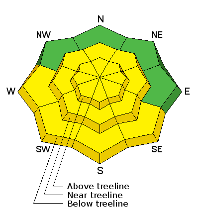
It's been about seven days since we have had a report of a human triggered slab avalanche in the Uinta's. However, we are still finding places that have shallow weak (faceted) snow on the ground with harder more dense snow above. Steep terrain (greater than 35 deg in steepness) that faces the north half of the compass, at or above tree line, and particularly slopes that previously avalanched during the big Solstice Storm should be considered suspect. Terrain with these characteristics had weak sugary snow develop due to their shallow nature, and January storms added roughly 3-5 feet of stronger snow on top. It's kind of like an early season snowpack and you know the drill by now- strong snow on weak snow... no good.
|
 |
weather Sunny skies for today with the chance of a few clouds rolling by. High temperatures reach into the mid 40's at 10,000' with overnight lows in the 30's. The winds will remain light out of the southwest. There is a chance for a couple of small storms to cross over northern Utah this weekend bringing mostly clouds and very little chance of snow. Next storm looks to be about a week out.
|
| general announcements Remember your information can save lives. If you see anything we should know about, please participate in the creation of our own community avalanche advisory by submitting snow and avalanche conditions. You can call me directly at 801-231-2170, email [email protected], or email by clicking HERE If Craig is unavailable you can reach his partner Trent at 801-455-7239, email [email protected] This is a great time of year to schedule a free avalanche awareness presentation for your group or club. You can contact me at 801-231-2170 or email [email protected]. To register for the first in our series of on-the-snow sled specific classes you can register here. The information in this advisory is from the US Forest Service which is solely responsible for its content. This advisory describes general avalanche conditions and local variations always occur. The information in this advisory expires 24 hours after the date and time posted, but will be updated by 7:00 AM on Saturday, February 13th.
|