| Please join us at the 23rd annual Black Diamond Fall Fundraiser Party Thursday Sept 15. Tickets are on sale now here, at the Black Diamond store & at REI. Special bonus raffle for online ticket purchasers! |
| Please join us at the 23rd annual Black Diamond Fall Fundraiser Party Thursday Sept 15. Tickets are on sale now here, at the Black Diamond store & at REI. Special bonus raffle for online ticket purchasers! |
| Advisory: Uintas Area Mountains | Issued by Craig Gordon for Wednesday - February 10, 2016 - 5:42am |
|---|


|
bottom line At and above treeline, especially in the wind zone, a MODERATE avalanche danger exists and human triggered avalanches are possible on steep, wind drifted slopes. Any avalanche that breaks to weak, sugary snow near the ground has the potential to be deep and dangerous. Remember- MODERATE avalanche danger means we can still trigger large avalanches in isolated areas. Steep sunny slopes get in on the act today and the danger of wet slides and sluffs increases to MODERATE with daytime heating. Wind sheltered terrain that is under 30 degrees in slope steepness is the ticket for finding both LOW avalanche danger and great riding conditions.
|
 |
special announcement
Join us next Tuesday for a companion rescue workshop hosted by our good friends at Weller Recreation. Click here for more details and to register. |
 |
current conditions High pressure continues dominating the weather pattern over the region, giving us clear skies and temperatures in the upper 20's and low 30's. Yep... it's warmer in the mountains this morning than in the City of Salt. Winds finally relaxed, switched to the southwest and are blowing 10-20 mph along the high peaks. Snow surface conditions are hit or miss, but you can still find soft settled powder on wind sheltered shady slopes.
Observer extraordinaire Ted Scroggin was in Millcreek yesterday and found a mixed bag of snow surface conditions. More on his travels here.
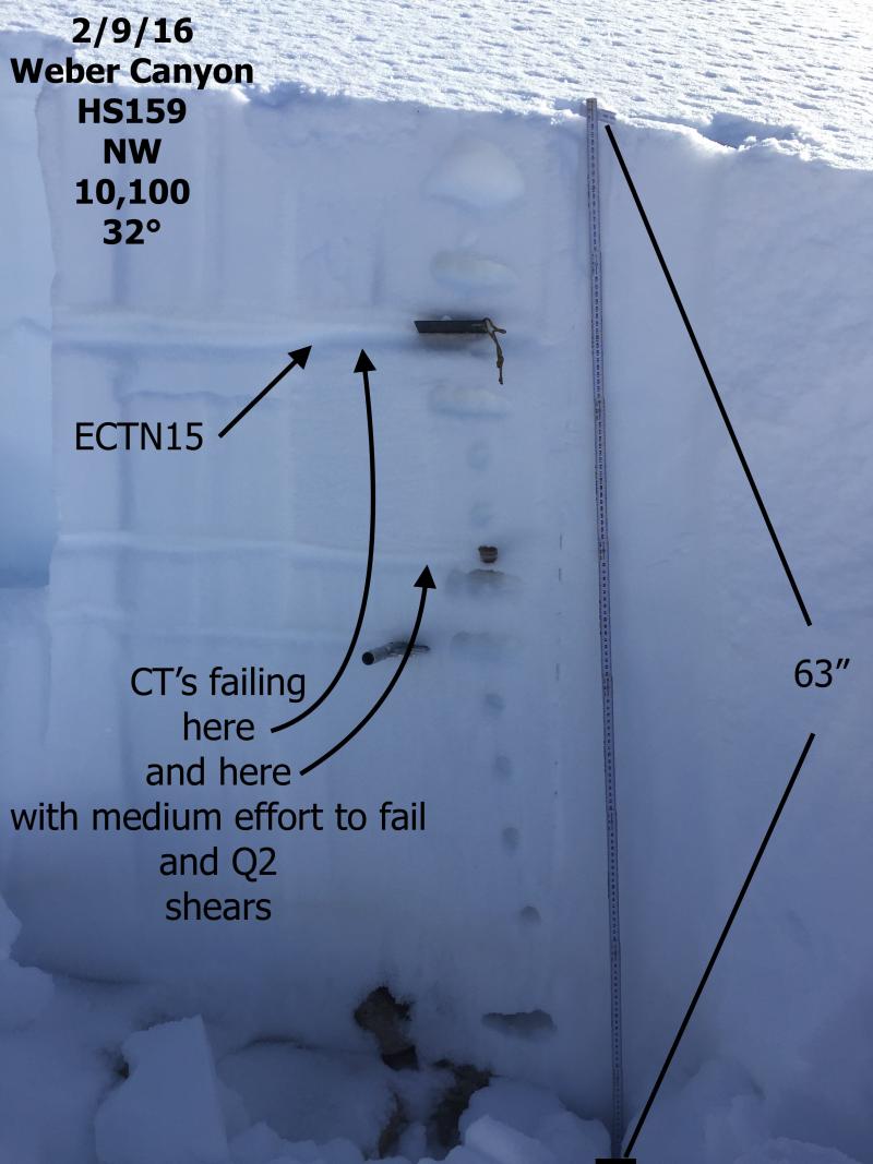
As always, thanks to JG for the most excellent snowpit diagram, which clearly illustrates our current snowpack setup. Trip reports and observations are found here.
|
 |
recent activity
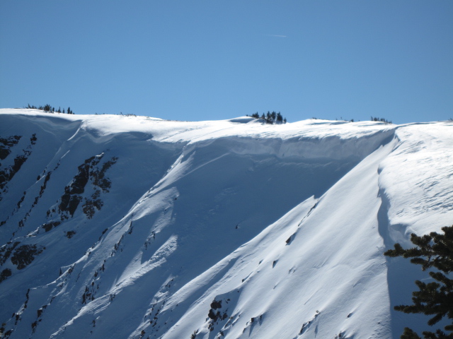
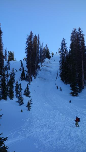
Ted discovered this wind slab which released naturally a couple days ago, on a steep shady slope in the Millcreek Drainage. Recent avalanche observations are found here. See or trigger an avalanche? Shooting cracks? Hear a collapse? It's simple. Go here to fill out an observation.
|
| type | aspect/elevation | characteristics |
|---|

|
|
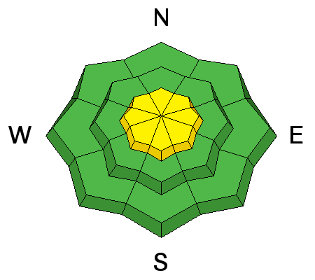
LIKELIHOOD
 LIKELY
UNLIKELY
SIZE
 LARGE
SMALL
TREND
 INCREASING DANGER
SAME
DECREASING DANGER
|
|
description
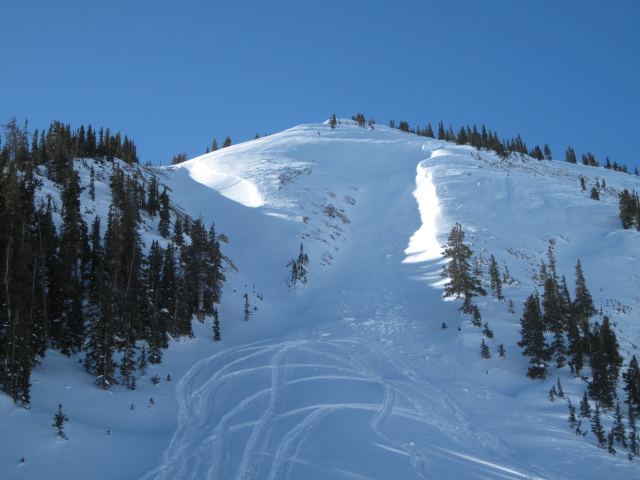
Recent winds have been all over the place and wind slabs are becoming more stubborn. However, with enough prodding I bet you could still trigger either an old or a freshly formed drift along the leeward side of upper elevation ridges. Easy to detect by their fat, rounded appearance, any drift in the wind zone has the potential to break deeper and wider than you might expect.
Fresh wind drifts like this one above that Ted spotted in Millcreek yesterday, are mostly isolated to steep, upper elevation terrain in the wind zone.
|
| type | aspect/elevation | characteristics |
|---|

|
|
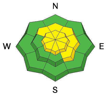
LIKELIHOOD
 LIKELY
UNLIKELY
SIZE
 LARGE
SMALL
TREND
INCREASING DANGER
SAME
DECREASING DANGER
|
|
description
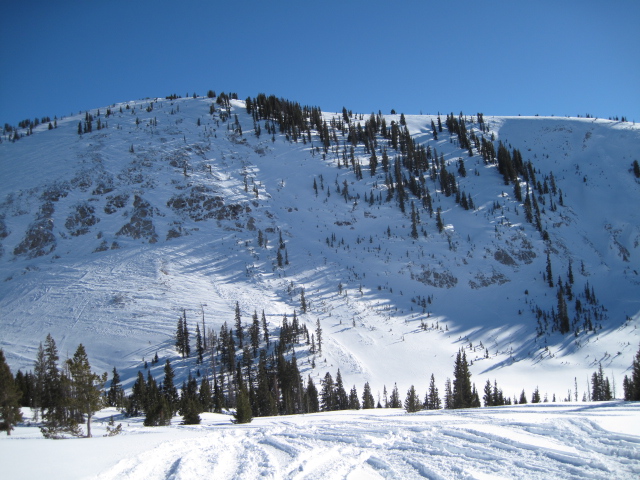
Deeply triggered slides are still on our radar, but they're becoming more elusive and harder to trigger. However, there is a common theme to this winters problem child... steep terrain that faces the north half of the compass, at or above tree line, and particularly slopes that previously avalanched during the big Solstice Storm should be considered suspect. Terrain with these characteristics had weak sugary snow develop due to their shallow nature, and January storms added roughly 3-5 feet of stronger snow on top. It's kind of like an early season snowpack and you know the drill by now- strong snow on weak snow... no es bueno.
With a good thump in the right place, this slide broke to the ground yesterday on a steep, shady, upper elevation slope in Upper Whitney Basin. No thumpers or thumpees where caught or carried in the thumping process. (Kikkert photo)
|
| type | aspect/elevation | characteristics |
|---|

|
|
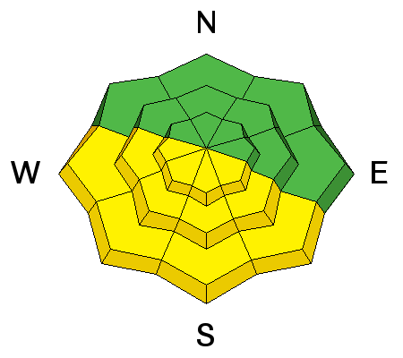
LIKELIHOOD
LIKELY
UNLIKELY
SIZE
 LARGE
SMALL
TREND
INCREASING DANGER
SAME
DECREASING DANGER
|
|
description
Strong sunshine and warm temperatures will soften the snow surface as the day wares on. If you're feeling like an ant under a magnifying glass.... so is the snow. During the heat of the day simply get off of an out from under steep sunny slopes and avoid terrain traps like gullies and road cuts where avalanche debris can pile up very deeply. |
 |
weather Other than a few high clouds and northerly winds increasing into the 20's and 30's, it'll be pretty quiet in this department. High temperatures reach into the mid 40's today with overnight lows in the 20's. About the same through the end of the work week.
|
| general announcements Remember your information can save lives. If you see anything we should know about, please participate in the creation of our own community avalanche advisory by submitting snow and avalanche conditions. You can call me directly at 801-231-2170, email [email protected], or email by clicking HERE If Craig is unavailable you can reach his partner Trent at 801-455-7239, email [email protected] This is a great time of year to schedule a free avalanche awareness presentation for your group or club. You can contact me at 801-231-2170 or email [email protected]. To register for the first in our series of on-the-snow sled specific classes you can register here. The information in this advisory is from the US Forest Service which is solely responsible for its content. This advisory describes general avalanche conditions and local variations always occur. The information in this advisory expires 24 hours after the date and time posted, but will be updated by 7:00 AM on Thursday, February 11th.
|