| Please join us at the 23rd annual Black Diamond Fall Fundraiser Party Thursday Sept 15. Tickets are on sale now here, at the Black Diamond store & at REI. Special bonus raffle for online ticket purchasers! |
| Please join us at the 23rd annual Black Diamond Fall Fundraiser Party Thursday Sept 15. Tickets are on sale now here, at the Black Diamond store & at REI. Special bonus raffle for online ticket purchasers! |
| Advisory: Uintas Area Mountains | Issued by Trent Meisenheimer for Saturday - February 6, 2016 - 4:48am |
|---|

|
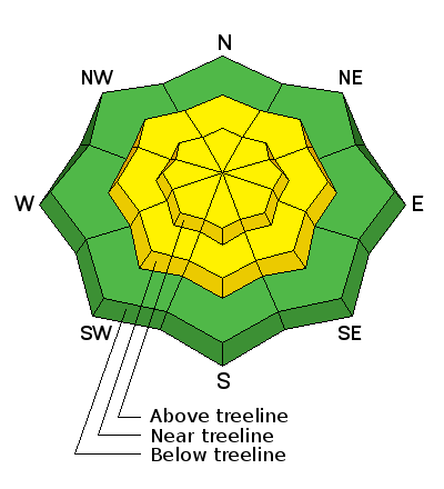
bottom line At and above treeline, especially in the wind zone, a MODERATE avalanche danger exist and human triggered avalanches are possible on steep, wind drifted slopes. Any avalanche that breaks to weak, sugary snow near the ground has the potential to be deep and dangerous. Remember that MODERATE danger means large avalanches in isolated areas. Wind sheltered terrain that is under 30 degrees in slope steepness is the ticket for finding both LOW avalanche danger and great riding conditions.
|
 |
special announcement Today should be a spectacular day in the mountains with great riding conditions - However, If you are heading into the backcountry lets make sure we all have the basic rescue gear - beacon, shovel and probes. Last year the Utah Avalanche Center alongside many great partners (Boondockers, Alpine Assassins, ISMA) put together a video called " Knowledge Is Powder " it's worth watching. Knowledge Is Powder - Snowmobiling from Trent Meisenheimer on Vimeo. |
 |
current conditions Under clear skies this morning we have cold temperatures and most trail head temps are hovering in the low teens. The upper mountain basins are a touch warmer due to the temperature inversion. The 6'' of new snow that fell in the past 48hrs really helped out the turning and riding conditions. Out of the wind effected terrain it's as good as it gets in Utah. Travel on sleds is easy and the boondocking is 5 star. The north west winds are currently blowing 15-20mph gusting into the 30's along the high 10,000' terrain. Picture below showing the freshies from yesterday, this was out of the wind effected terrain - excellent turning and riding. (Photo: Gordon)
Trip reports and observations are found here.
|
 |
recent activity No new avalanche activity was reported from the backcountry yesterday. Recent avalanche observations are found here. See or trigger an avalanche? Shooting cracks? Hear a collapse? It's simple. Go here to fill out an observation.
|
| type | aspect/elevation | characteristics |
|---|

|
|
LIKELIHOOD
 LIKELY
UNLIKELY
SIZE
 LARGE
SMALL
TREND
 INCREASING DANGER
SAME
DECREASING DANGER
|
|
description
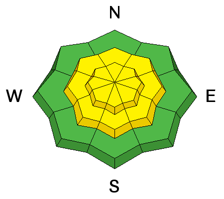
Most of the damage was done yesterday, but the annoying northwest winds are not going to let up today and will continue to blow 25-30mph gusting into the 40's. This will whip up any of the remaining fresh snow into wind drifts, that will be sensitive to the additional weight of a rider. While mostly confined to the leeward side of upper elevation ridges, I wouldn't be surprised to find cross-loaded terrain features like chutes, gullies, and sub-ridges. Any fresh drift in the wind zone has the potential to break deeper and wider than you might expect. These wind drift are easy to see and detect, by their fat rounded, pillowy appearance, I'd avoid steep, wind drifted slopes today especially if the snow feels or sounds hollow like a drum.
|
| type | aspect/elevation | characteristics |
|---|

|
|
LIKELIHOOD
 LIKELY
UNLIKELY
SIZE
 LARGE
SMALL
TREND
 INCREASING DANGER
SAME
DECREASING DANGER
|
|
description
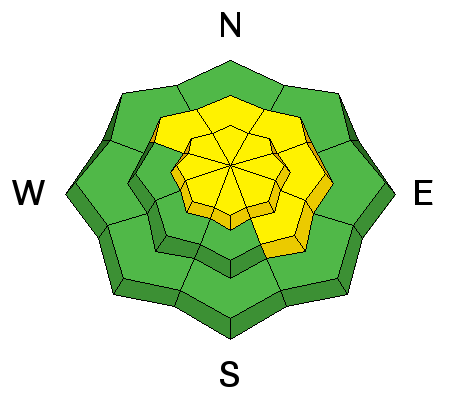
While new wind drifts are today's most obvious and straight-forward avalanche problem, don't get complacent thinking this is the only avalanche dragon out there. The last reported human triggered deep slab avalanche was on January 27th near Current Creek peak found here it's a great reminder of the sleeping avalanche problem we can't forget. Moderate danger means " Heightened avalanche conditions on specific terrain features. Evaluate snow and terrain carefully; identify features of concern." Features of concern - are the avalanche paths that generally face the west to north to easterly facing aspect at or above tree line that previously avalanched back in late December. These slide paths that avalanched, had weak faceted (sugary) snow develop due to their shallow nature, now we have added roughly 3-5 feet of stronger snow on top of the weaker snow at the ground. The problem now, is we can't tell what slopes avalanched back in December because everything has filled back in and they all look the same. My strategy for this is to assume that all slopes approaching 35 degrees in steepness facing the west to north to easterly terrain and above tree line are all suspect for now. It's been 6 days since that last reported slab avalanche from the backcountry found here. I would like to see a little more time go by before we punch the big terrain.
|
 |
weather Skies are clear this morning and the northwest winds are keeping the mountains cold. We should see an increase in wind and clouds starting around noon today. Winds are forecasted to blow from the northwest 25-30mph gusting into the 40's at the high elevations. Temperatures will rise into the 20's today and dip back into the teens tonight. The big picture - we have a ridge of high pressure building into the state with a disturbance over the area today bringing clouds and no precipitation. Sunday we will remain under a cool northwest flow and have partly cloudy skies. Monday morning we will see clearing skies and the return of sunshine, it looks to be quite warm by Tuesday with 10,000' temperatures reaching 38 degrees. No major storms are forecasted for the next week.
|
| general announcements Remember your information can save lives. If you see anything we should know about, please participate in the creation of our own community avalanche advisory by submitting snow and avalanche conditions. You can call me directly at 801-231-2170, email [email protected], or email by clicking HERE If Craig is unavailable you can reach his partner Trent at 801-455-7239, email [email protected] This is a great time of year to schedule a free avalanche awareness presentation for your group or club. You can contact me at 801-231-2170 or email [email protected]. To register for the first in our series of on-the-snow sled specific classes you can register here. The information in this advisory is from the US Forest Service which is solely responsible for its content. This advisory describes general avalanche conditions and local variations always occur. The information in this advisory expires 24 hours after the date and time posted, but be will be updated by 7:00 AM on Sunday, February 7th.
|


