| Please join us at the 23rd annual Black Diamond Fall Fundraiser Party Thursday Sept 15. Tickets are on sale now here, at the Black Diamond store & at REI. Special bonus raffle for online ticket purchasers! |
| Please join us at the 23rd annual Black Diamond Fall Fundraiser Party Thursday Sept 15. Tickets are on sale now here, at the Black Diamond store & at REI. Special bonus raffle for online ticket purchasers! |
| Advisory: Uintas Area Mountains | Issued by Craig Gordon for Friday - February 5, 2016 - 4:26am |
|---|


|
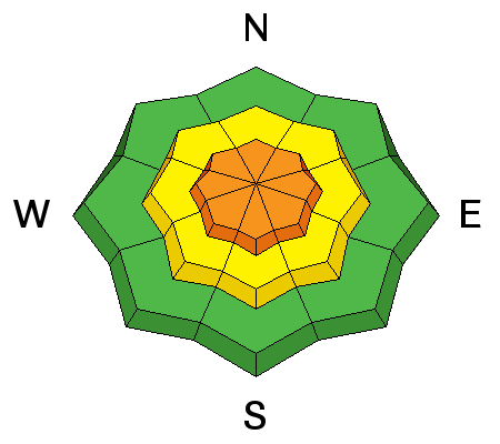
bottom line At and above treeline, especially in the wind zone, pockets of CONSIDERABLE avalanche danger exist and human triggered avalanches are likely on steep, wind drifted slopes. Any avalanche that breaks to weak, sugary snow near the ground has the potential to be deep and dangerous. Mid elevation terrain offers a MODERATE avalanche danger and human triggered avalanches are possible on steep slopes with recent deposits of wind drifted snow. Wind sheltered terrain is the ticket for finding both LOW avalanche danger and cold, deep snow.
|
 |
current conditions We're having some technical issues with our Uinta weather station network and I hope to get everything back online today. From what I can piece together, a good shot of snow slid through the region last night with the North Slope picking up 5" of medium density snow. Half that amount fell on the south half of the range. Temperatures are about 10 degrees warmer this morning than yesterday at this time, hovering in the low to mid teens. Along the high peaks, west and northwest winds blew in the 30's and 40's yesterday, but backed off around 1:00 this morning and are currently blowing 15-25 mph. The riding and turning conditions are exeptionally good, especially in mid and low elevation, wind sheltered terrain. Trip reports and observations are found here.
|
 |
recent activity
This natural slide occurred as a result of the big east wind event earlier this week. While the crown is filled in, the common theme remains the same. This is a steep northeast facing slope and is a "repeater"... meaning it avalanched to the ground early this season. Recent avalanche observations are found here. See or trigger an avalanche? Shooting cracks? Hear a collapse? It's simple. Go here to fill out an observation.
|
| type | aspect/elevation | characteristics |
|---|

|
|
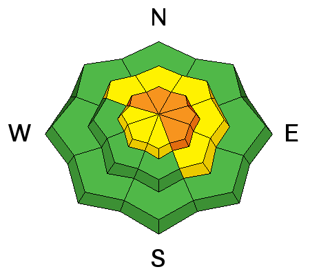
LIKELIHOOD
 LIKELY
UNLIKELY
SIZE
 LARGE
SMALL
TREND
 INCREASING DANGER
SAME
DECREASING DANGER
|
|
description
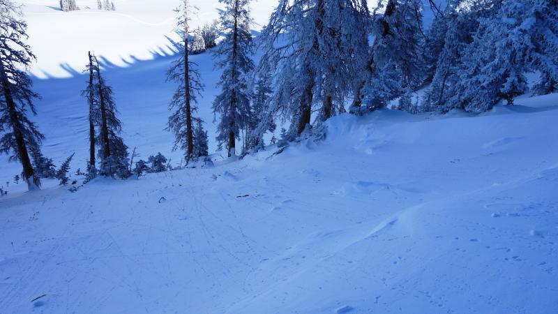
Ridgetop winds have been busy at work, whipping the fresh snow into drifts, sensitive to the additional weight of a rider. While mostly confined to the leeward side of upper elevation ridges, I wouldn't be surprised to find cross-loaded terrain features like chutes, gullies, and sub-ridges. Any fresh drift in the wind zone has the potential to break deeper and wider than you might expect. Easy to detect by their fat rounded appearance, I'd avoid steep, wind drifted slopes today especially if the snow feels or sounds hollow like a drum.
|
| type | aspect/elevation | characteristics |
|---|

|
|
LIKELIHOOD
 LIKELY
UNLIKELY
SIZE
 LARGE
SMALL
TREND
 INCREASING DANGER
SAME
DECREASING DANGER
|
|
description
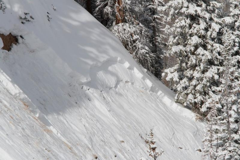
While both new and old wind drifts are today's most obvious and straight-forward avalanche problem, don't get complacent thinking this is the only avalanche dragon out there. As a matter of fact, more dangerous and less predictable, is any slide that breaks to weak layers of snow near the ground. The most likely terrain to trigger a deep, dangerous slide are steep slopes facing the north half of the compass, particularly those that avalanched big during the Solstice Storm.
Perfect example of what we're dealing with right now. Fresh wind slab that once initiated, quickly breaks to old snow near the ground.
|
 |
weather Light snow showers continue for the next couple of hours, but in general, last night's storm is headed east of our region and skies should become partly cloudy later this morning. West and northwest winds remain reasonable, blowing in the 15-25 mph range. High temperatures rise into the mid 20's before diving into the teens overnight. Northwest winds increase late tonight and gust in the 30's and 40's. High pressure builds for the weekend, giving us sunny skies and warming temperatures.
|
| general announcements Remember your information can save lives. If you see anything we should know about, please participate in the creation of our own community avalanche advisory by submitting snow and avalanche conditions. You can call me directly at 801-231-2170, email [email protected], or email by clicking HERE This is a great time of year to schedule a free avalanche awareness presentation for your group or club. You can contact me at 801-231-2170 or email [email protected]. To register for the first in our series of on-the-snow sled specific classes you can register here. The information in this advisory is from the US Forest Service which is solely responsible for its content. This advisory describes general avalanche conditions and local variations always occur. The information in this advisory expires 24 hours after the date and time posted, but be will be updated by 7:00 AM on Saturday, February 6th.
|