| Please join us at the 23rd annual Black Diamond Fall Fundraiser Party Thursday Sept 15. Tickets are on sale now here, at the Black Diamond store & at REI. Special bonus raffle for online ticket purchasers! |
| Please join us at the 23rd annual Black Diamond Fall Fundraiser Party Thursday Sept 15. Tickets are on sale now here, at the Black Diamond store & at REI. Special bonus raffle for online ticket purchasers! |
| Advisory: Uintas Area Mountains | Issued by Craig Gordon for Tuesday - February 2, 2016 - 4:13am |
|---|

|
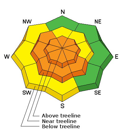
bottom line At and above treeline, in upper elevation terrain, the avalanche danger is CONSIDERABLE and human triggered avalanches are likely on steep, wind drifted slopes. Any avalanche that breaks to weak, sugary snow near the ground has the potential to be deep and dangerous. Mid elevation terrain offers a MODERATE avalanche danger and human triggered avalanches are possible on steep slopes with recent deposits of wind drifted snow. Looking for LOW avalanche danger? Head to low elevation, wind sheltered terrain.
|
 |
special announcement
Thanks to the crew at Park City Pro Patrol for hosting this event. Hope to see y'all at Park City HS Tuesday night. |
 |
current conditions Yesterday's storm slammed southern Utah, but wrap around moisture delivered a couple inches of light density snow to the eastern front. Unfortunately for us, powerful storms churning in the four corners produce big east-northeast winds for the Uinta's and yesterday's storm system didn't buck the trend. Along the high peaks winds raged into the 50's and 60's and essentially crashed the great powder party we've been having. Winds switched to the northwest early this morning and are currently blowing 20-40 mph along the high ridges. Under clear skies it's cold with most mountain location reporting temperatures near zero degrees. You're gonna have to get creative today to find snow that isn't wind jacked. Low elevation wind sheltered terrain could be an exotic way to fly. Trip reports and observations are found here.
|
 |
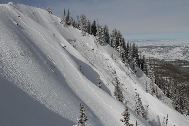
recent activity We couldn't see anything yesterday, but this slide below from Sunday captures the essence of what we're dealing with.
It's pretty clear from this image above... two distinct avalanche problems. Shallow wind drifts and of course our problem child, deeper buried weak layers.
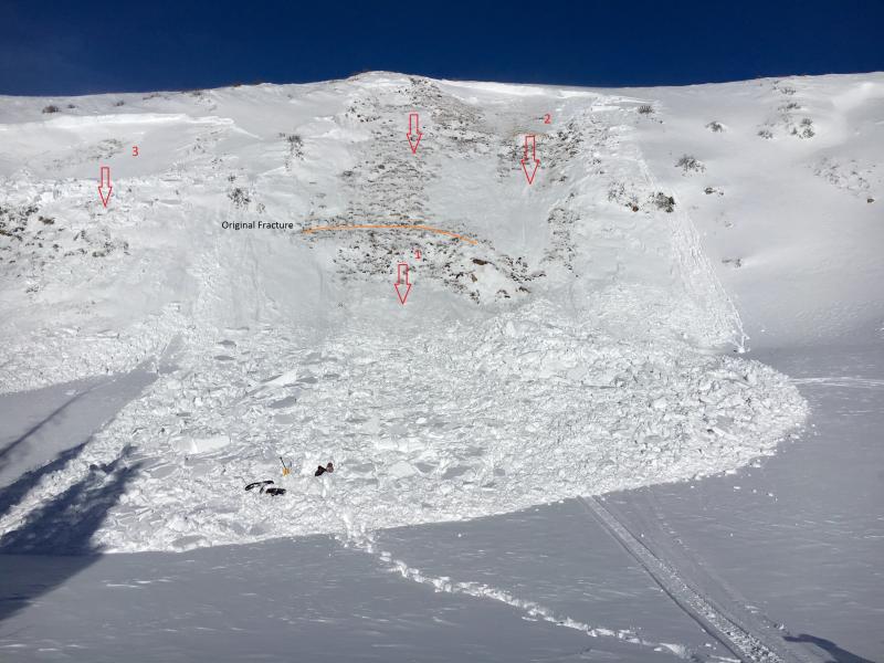
This "repeater" slide in Upper Weber Canyon, broke to old snow near the ground Sunday and was triggered from the top of slope on a steep Northeast facing slope. (Deutschlander photo) Recent avalanche observations are found here. See or trigger an avalanche? Shooting cracks? Hear a collapse? It's simple. Go here to fill out an observation.
|
| type | aspect/elevation | characteristics |
|---|

|

|
LIKELIHOOD
 LIKELY
UNLIKELY
SIZE
 LARGE
SMALL
TREND
 INCREASING DANGER
SAME
DECREASING DANGER
|
|
description
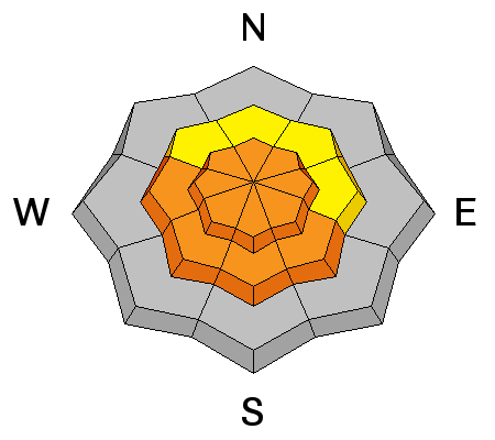
East and northeast winds cranked yesterday, depositing snow in terrain with a westerly component to its aspect, which is unusual for us. The strong, cow tipping winds (though no cows were hurt in the tipping process) deposited snow not only along the leeward side of upper elevation ridges, but also much lower than you'd normally expect to see fresh wind drifts. In either case, today's slabs will be sensitive to the weight of a rider and may break deeper and wider than you might expect. Easy to detect by their fat rounded appearance, I'd avoid any steep, wind drifted slope today especially if the snow feels or sounds hollow like a drum.
|
| type | aspect/elevation | characteristics |
|---|

|
|
LIKELIHOOD
 LIKELY
UNLIKELY
SIZE
 LARGE
SMALL
TREND
 INCREASING DANGER
SAME
DECREASING DANGER
|
|
description
While fresh wind drifts are today's most obvious and straight-forward avalanche problem, don't get complacent thinking this is the only avalanche dragon out there. As a matter of fact, more dangerous and less predictable, is any slide that breaks to weak layers of snow near the ground. The most likely terrain to trigger a deep, dangerous slide are steep slopes facing the north half of the compass, particularly those that avalanched big during the Solstice Storm.
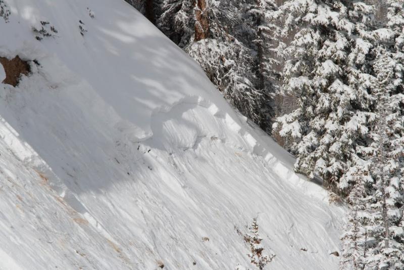
Sled triggered slide from last Thursday, clearly shows how we can initiate a deep, scary avalanche from low on the slope. |
 |
weather Partly cloudy skies with temperatures only rising into the low teens are on tap today. Northwest winds are going to make ridgeline travel Arctic-like with wind chill values near -30 degrees. Overnight lows crash into negative territory. A warming trend begins Wednesday morning and winds relax. A short break in the warming trend is expected Thursday with the passage of a splitting system, but only light snow is expected. Sunny and warm for the weekend.
|
| general announcements Remember your information can save lives. If you see anything we should know about, please participate in the creation of our own community avalanche advisory by submitting snow and avalanche conditions. You can call me directly at 801-231-2170, email [email protected], or email by clicking HERE This is a great time of year to schedule a free avalanche awareness presentation for your group or club. You can contact me at 801-231-2170 or email [email protected]. To register for the first in our series of on-the-snow sled specific classes you can register here. The information in this advisory is from the US Forest Service which is solely responsible for its content. This advisory describes general avalanche conditions and local variations always occur. The information in this advisory expires 24 hours after the date and time posted, but be will be updated by 7:00 AM on Wednesday, February 3rd.
|