| Please join us at the 23rd annual Black Diamond Fall Fundraiser Party Thursday Sept 15. Tickets are on sale now here, at the Black Diamond store & at REI. Special bonus raffle for online ticket purchasers! |
| Please join us at the 23rd annual Black Diamond Fall Fundraiser Party Thursday Sept 15. Tickets are on sale now here, at the Black Diamond store & at REI. Special bonus raffle for online ticket purchasers! |
| Advisory: Uintas Area Mountains | Issued by Craig Gordon for Monday - February 1, 2016 - 4:44am |
|---|

|
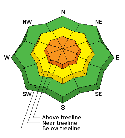
bottom line At and above treeline, in upper elevation terrain, the avalanche danger is CONSIDERABLE and human triggered avalanches are likely on steep, wind drifted slopes. Any avalanche that breaks to weak, sugary snow near the ground has the potential to be deep and dangerous. Mid elevation terrain offers a MODERATE avalanche danger and human triggered avalanches are possible on steep slopes with recent deposits of wind drifted snow. Looking for LOW avalanche danger? Head to low elevation, wind sheltered terrain.
|
 |
special announcement
Thanks to the crew at Park City Pro Patrol for hosting this event. Hope to see y'all at Park City HS Tuesday night. |
 |
current conditions Wrap around moisture is edging into the southern end of the range where the terrain around Daniels and Currant Creek picked up 5" of very light density snow. The further north you travel snow totals are marginal, just an inch or two. East and northeast winds ramped up overnight and are blowing 20-35 mph along the high ridges. It's cold and temperatures are generally in the single digits and low teens. Riding and turning conditions remain quite good and wind sheltered terrain is the ticket. Trip reports and observations are found here.
|
 |
recent activity
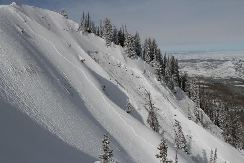
It's pretty clear from this image above... two distinct avalanche problems. Shallow wind drifts and of course our problem child, deeper buried weak layers.
This "repeater" slide in Upper Weber Canyon, broke to old snow near the ground yesterday and was triggered from the top of slope on a steep Northeast facing slope. (Deutschlander photo)
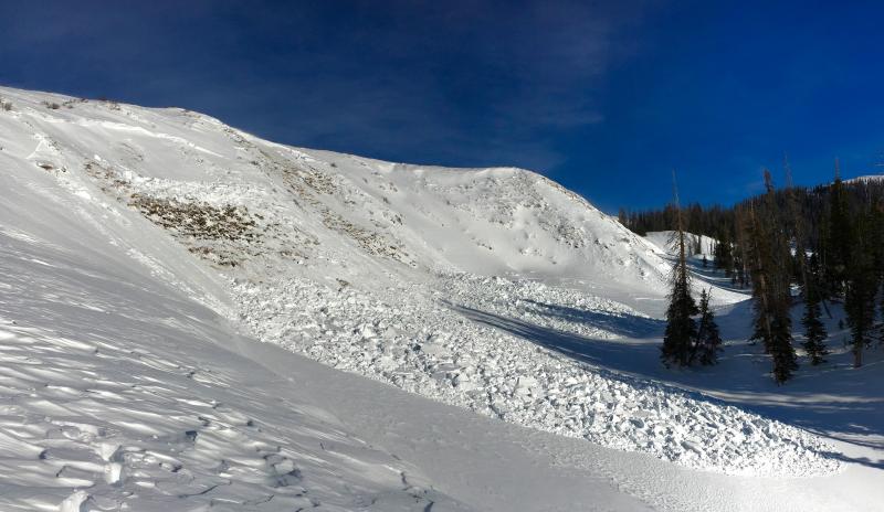
Close call on the southern half of the range Thursday near Currant Creek Peak where the pack is slightly thinner. This sled triggered slide broke to the ground in steep, rocky, wind loaded terrain. One rider is completely buried with a hand sticking out. Wiggling fingers above the debris, clue partners to his location and a rescue quickly ensues. All is good at the end of the day, but this avalanche is a perfect example of the tricky persistent slab avalanche problem we're dealing with right now. More on the slide found here. (Thanks to Jeff Turner for the great info and photos!) Recent avalanche observations are found here. See or trigger an avalanche? Shooting cracks? Hear a collapse? It's simple. Go here to fill out an observation.
|
| type | aspect/elevation | characteristics |
|---|

|

|
LIKELIHOOD
 LIKELY
UNLIKELY
SIZE
 LARGE
SMALL
TREND
 INCREASING DANGER
SAME
DECREASING DANGER
|
|
description
The most dangerous avalanche problem we're dealing with is any slide that breaks to weak layers of snow near the ground. It's actually a bit complicated because we've got a myriad of weak layers, some of them are buried under Friday night's storm, some of them buried deeper in the snowpack. Problem is, it's gonna be a bit deceiving today because the avalanche danger isn't going to be in your face. As a matter of fact, most steep terrain is just waiting for a trigger like us to come along and knock the legs out from underneath it. Here's the scary part... once triggered, today's avalanches have the potential to break deep and wide, failing on old sugary layers of snow near the ground and taking out the entire seasons snowpack. The most likely place to trigger a deep, dangerous slide is steep terrain facing the north half of the compass, particularly slopes that avalanched big during the Solstice Storm. It doesn't mean we can't ride, actually with the amazing coverage we have this season there's lots of options. We just need to tone down our objectives and our slope angles, and simply stay off of and out from under steep, wind drifted terrain. We can have a blast carving deep trenches in wide open meadows, far away from anything steep hanging above us.
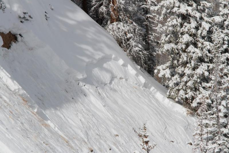
It's tricky out there and this is what we're dealing with. Two close calls last week with avalanches breaking to the ground. (Dickerson and Turner photos)
|
| type | aspect/elevation | characteristics |
|---|

|

|
LIKELIHOOD
 LIKELY
UNLIKELY
SIZE
 LARGE
SMALL
TREND
 INCREASING DANGER
SAME
DECREASING DANGER
|
|
description
East and Northeast winds are busy at work creating fresh drifts sensitive to the weight of a rider. Heads up.... you'll find these forming in terrain with a westerly component to its aspect which is unusual for us. Easy to detect by their fat rounded appearance, I'd avoid any steep, wind drifted slope today especially if the snow feels or sounds hollow like a drum. |
 |
weather Snow continues through the day with an additional 3"-6" expected. East and Northeast winds blow in the 30's and 40's along the high peaks and temperatures remain cold, in the upper teens. Overnight lows crash to near zero. Snow showers linger into Tuesday before high pressure builds midweek.
|
| general announcements Remember your information can save lives. If you see anything we should know about, please participate in the creation of our own community avalanche advisory by submitting snow and avalanche conditions. You can call me directly at 801-231-2170, email [email protected], or email by clicking HERE This is a great time of year to schedule a free avalanche awareness presentation for your group or club. You can contact me at 801-231-2170 or email [email protected]. To register for the first in our series of on-the-snow sled specific classes you can register here. The information in this advisory is from the US Forest Service which is solely responsible for its content. This advisory describes general avalanche conditions and local variations always occur. The information in this advisory expires 24 hours after the date and time posted, but be will be updated by 7:00 AM on Tuesday, February 2nd.
|