| Please join us at the 23rd annual Black Diamond Fall Fundraiser Party Thursday Sept 15. Tickets are on sale now here, at the Black Diamond store & at REI. Special bonus raffle for online ticket purchasers! |
| Please join us at the 23rd annual Black Diamond Fall Fundraiser Party Thursday Sept 15. Tickets are on sale now here, at the Black Diamond store & at REI. Special bonus raffle for online ticket purchasers! |
| Advisory: Uintas Area Mountains | Issued by Craig Gordon for Sunday - January 31, 2016 - 5:07am |
|---|

|
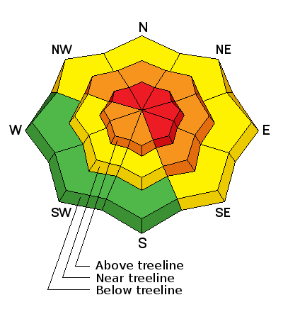
bottom line At and above treeline, in upper elevation terrain, the avalanche danger is CONSIDERABLE and human triggered avalanches are likely on steep, wind drifted slopes, especially those facing the north half of the compass. While not widespread, but within these terrain parameters, you'll find pockets of HIGH avalanche danger, particularly on slopes that slid to the ground during the big Solstice storm. Any avalanche that breaks to weak, sugary snow near the ground has the potential to be deep and dangerous. Mid elevation terrain offers a MODERATE avalanche danger and human triggered avalanches are possible on steep slopes with recent deposits of wind drifted snow. Looking for LOW avalanche danger? Head to low elevation, wind sheltered terrain.
|
 |
special announcement
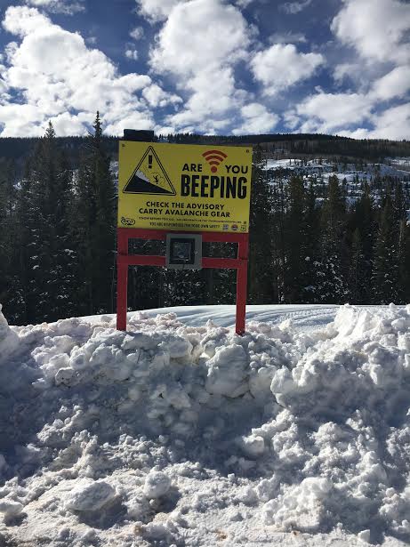
We installed a new beacon checker at the Soapstone Trailhead and Beacon Basin is up and running at Nobletts.... thanks to Trace and Miles for putting the back braces on and gittn' r done! |
 |
current conditions Wow... what a great storm for the eastern front! Cold unstable air moved over the region early Saturday morning and snow totals quickly started stacking up. The northern half of the range received close to 16" of snow, while terrain on the south half of the range, from about Nobletts to Current Creek stacked up closer to 10". Skies cleared late last night and temperatures crashed like a bad dot.com investment, bottoming out near zero degrees where they sit this morning. West and northwest winds backed off dramatically around midnight and are currently blowing 10-15 mph, even along the highest peaks. The snow is cold, it's light, and yeah... it's epic! Trip reports and observations are found here.
|
 |
recent activity
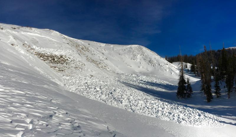
Close call on the southern half of the range Thursday near Currant Creek Peak where the pack is slightly thinner. This sled triggered slide broke to the ground in steep, rocky, wind loaded terrain. One rider is completely buried with a hand sticking out. Wiggling fingers above the debris, clue partners to his location and a rescue quickly ensues. All is good at the end of the day, but this avalanche is a perfect example of the tricky persistent slab avalanche problem we're dealing with right now. More on the slide found here. (Thanks to Jeff Turner for the great info and photos!) Recent avalanche observations are found here. See or trigger an avalanche? Shooting cracks? Hear a collapse? It's simple. Go here to fill out an observation.
|
| type | aspect/elevation | characteristics |
|---|

|

|
LIKELIHOOD
 LIKELY
UNLIKELY
SIZE
 LARGE
SMALL
TREND
 INCREASING DANGER
SAME
DECREASING DANGER
|
|
description
The new storm snow is settling rapidly, though there might be a wind drift or two sensitive to our additional weight. However, don't get lulled into thinking that's the only avalanche problem we're dealing with. It's actually a bit complicated because we've got a myriad of weak layers, some of them are buried under Friday night's storm, some of them buried deeper in the snowpack near the ground... and that's the weak layer we're most concerned with. Here's the deal- we've added over an inch of water to our snowpack and it'll take a little bit of time to adjust. Problem is, it's gonna be a bit deceiving today because the avalanche danger isn't going to be in your face. You're not going to see big, deep avalanches everywhere and think, "man it's sketchy out here". As a matter of fact, most steep terrain is just waiting for a trigger like us to come along and knock the legs out from underneath it. Here's the scary part... once triggered, today's avalanches have the potential to break deep and wide, failing on old sugary layers of snow near the ground and taking out the entire seasons snowpack. The most likely place to trigger a deep, dangerous slide is steep terrain facing the north half of the compass, particularly slopes that avalanched big during the Solstice Storm. It doesn't mean we can't ride, actually with the amazing coverage we have this season there's lots of options. We just need to tone down our objectives and our slope angles, and simply stay off of and out from under steep, wind drifted terrain. We can have a blast carving deep trenches in wide open meadows, far away from anything steep hanging above us.
It's tricky out there and this is what we're dealing with. Two close calls this week with avalanches breaking to the ground. (Dickerson and Turner photos)
|
 |
weather Clear skies, cold temperatures, and light winds are on tap for the region today as yesterday's storm slides east. High temperatures climb into the upper teens and low 20's and dip into the low teens overnight. Northwest winds remain reasonable, blowing just 10-20 mph along the ridges. Looks like Monday we see a few high clouds drift into the region as a rather large storm system dives to our south and pounds central and southern Utah. Wrap around moisture has the potential to give us close to a foot of snow by late Tuesday and we'll have more beta on this scenario for tomorrows update.
|
| general announcements Remember your information can save lives. If you see anything we should know about, please participate in the creation of our own community avalanche advisory by submitting snow and avalanche conditions. You can call me directly at 801-231-2170, email [email protected], or email by clicking HERE This is a great time of year to schedule a free avalanche awareness presentation for your group or club. You can contact me at 801-231-2170 or email [email protected]. To register for the first in our series of on-the-snow sled specific classes you can register here. The information in this advisory is from the US Forest Service which is solely responsible for its content. This advisory describes general avalanche conditions and local variations always occur. The information in this advisory expires 24 hours after the date and time posted, but be will be updated by 7:00 AM on Monday, February 1st.
|