| Please join us at the 23rd annual Black Diamond Fall Fundraiser Party Thursday Sept 15. Tickets are on sale now here, at the Black Diamond store & at REI. Special bonus raffle for online ticket purchasers! |
| Please join us at the 23rd annual Black Diamond Fall Fundraiser Party Thursday Sept 15. Tickets are on sale now here, at the Black Diamond store & at REI. Special bonus raffle for online ticket purchasers! |
| Advisory: Uintas Area Mountains | Issued by Craig Gordon for Monday - January 25, 2016 - 4:10am |
|---|

|
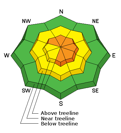
bottom line In the wind zone, at and above treeline, a CONSIDERABLE avalanche danger exists. Human triggered avalanches are probable on steep, wind drifted slopes, especially on slopes with an easterly component to their aspect. Any avalanche that breaks to weak, sugary snow near the ground has the potential to be deep and dangerous. In steep, mid elevation terrain, a MODERATE avalanche danger is found and human triggered avalanches are possible on steep slopes with recent deposits of wind drifted snow. Looking for LOW avalanche danger? Simply avoid being on or under steep wind drifted slopes. You can have a blast carving deep trenches in big, open meadows or seek out turns in wind sheltered terrain.
|
 |
special announcement Our collective thoughts, prayers, and energy go out to friends and family of Douglas Green who was tragically killed in an avalanche accident Thursday while skiing Gobbler's Knob in Big Cottonwood Canyon. An accident report is found here. |
 |
current conditions The North Slope faired well with the recent round of snow and another 6" stacked up in the past 24 hours. Storm totals north of the Mirror Lake Corridor are close to a foot, with about half that amount the further south you travel. Current temperatures are in the mid teens. West and northwest winds increased Sunday afternoon, gusting into the 50's and 60's along the high peaks, but slowly decreased around midnight and are currently blowing 15-25 mph. Conditions are about as good as they get... it's over-the-head and over-the-hood,
January has been good to the eastern front and the range is growing phat and getting white! Trip reports and observations are found here.
|
 |
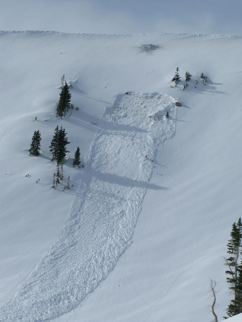
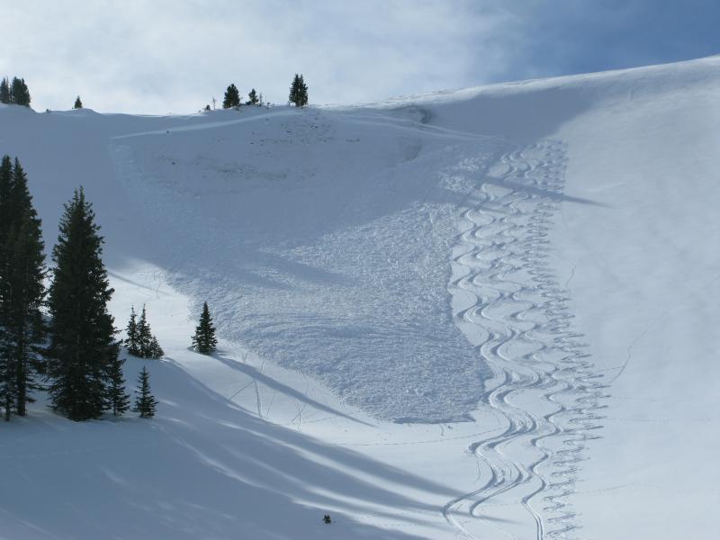
recent activity
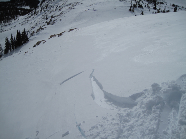
On Friday, this pocket was triggered by collapsing the slope from above.
And this pocket was triggered low on the slope... same characteristics. Common theme is steep, north facing terrain that slid to the ground during the Solstice Storm. Recent avalanche observations are found here. See or trigger an avalanche? Shooting cracks? Hear a collapse? It's simple. Go here to fill out an observation.
|
| type | aspect/elevation | characteristics |
|---|

|
|
LIKELIHOOD
 LIKELY
UNLIKELY
SIZE
 LARGE
SMALL
TREND
 INCREASING DANGER
SAME
DECREASING DANGER
|
|
description
Two differant snowpacks... two differant problems. Where the pack is deep, fresh wind drifts breaking at or below your skis, board, or sled are today's most obvious avalanche problem. While generally manageable in size, a rogue slab on a steep, leeward slope in the wind zone, could take you for a ride and let you know who's boss. Best bet is not to pull on the dogs tail and simply avoid fat, rounded pieces of snow, especially if they sound hollow like a drum.
|
| type | aspect/elevation | characteristics |
|---|

|
|
LIKELIHOOD
LIKELY
UNLIKELY
SIZE
 LARGE
SMALL
TREND
 INCREASING DANGER
SAME
DECREASING DANGER
|
|
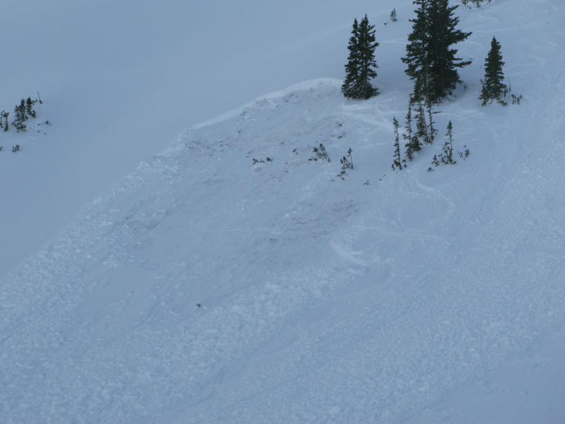
description
Not so obvious, but much more dangerous, are avalanches that break to weak snow near the ground. This slide triggered Friday on a steep, wind drifted, north facing slope is a repeater. It avalanched early in January, breaking to the ground, leaving behind a weak, shallow snowpack. We were able to safely navigate our way down the slope by reducing our slope angle and descending terrain where we know the pack is deep. If you don't have a good history of the snowpack or the terrain your riding in... you're rolling the dice. |
 |
weather Scattered snow showers this morning should give way to clearing skies throughout the day and overnight. High temperatures reach into the mid 20's and overnight lows dip into the single digits. West-northwest winds should be relatively well-behaved, blowing 15-25 mph with a few gusts in the 30's along the high peaks. High pressure builds Tuesday through Thursday with a strong warming trend forecast. Perhaps a little brush-by late in the week.
|
| general announcements Remember your information can save lives. If you see anything we should know about, please participate in the creation of our own community avalanche advisory by submitting snow and avalanche conditions. You can call me directly at 801-231-2170, email [email protected], or email by clicking HERE This is a great time of year to schedule a free avalanche awareness presentation for your group or club. You can contact me at 801-231-2170 or email [email protected]. To register for the first in our series of on-the-snow sled specific classes you can register here. The information in this advisory is from the US Forest Service which is solely responsible for its content. This advisory describes general avalanche conditions and local variations always occur. The information in this advisory expires 24 hours after the date and time posted, but be will be updated by 7:00 AM on Tuesday, January 26th.
|