| Please join us at the 23rd annual Black Diamond Fall Fundraiser Party Thursday Sept 15. Tickets are on sale now here, at the Black Diamond store & at REI. Special bonus raffle for online ticket purchasers! |  |

| Please join us at the 23rd annual Black Diamond Fall Fundraiser Party Thursday Sept 15. Tickets are on sale now here, at the Black Diamond store & at REI. Special bonus raffle for online ticket purchasers! |  |
| Advisory: Uintas Area Mountains | Issued by Craig Gordon for Friday - January 22, 2016 - 5:13am |
|---|
 |
special announcement Our collective thoughts, prayers, and energy go out to friends and family of Douglas Green who was tragically killed in an avalanche accident yesterday while skiing Gobbler's Knob in Big Cottonwood Canyon. A preliminary accident report is found here. |
 |
current conditions Skies are clear, temperatures in the mid 20's, and winds light and variable, blowing just 10-20 mph even along the highest ridges. Recent storms stacked up a couple feet of snow and the riding is as good as it gets! The sun is getting stronger and south facing terrain took on some heat yesterday. However, cold dry powder is easily found on shady, wind shelterd slopes. Trip reports and observations are found here.
|
 |
recent activity Yeah it's tricky... since Sunday there have been lots of avalanches in the mountains of northern Utah, a number of close calls, and sadly, one avalanche accident.
Manageable avalanche in Duke Cirque breaking within the new storm snow Wednesday. (Janulaitis photo) Ob from that zone is found here.
Not so manageable avalanche breaking to weak Solstice snow near the ground on Sunday. Recent avalanche observations are found here. See or trigger an avalanche? Shooting cracks? Hear a collapse? It's simple. Go here to fill out an observation.
|
| type | aspect/elevation | characteristics |
|---|


|


|

LIKELIHOOD
 LIKELY
UNLIKELY
SIZE
 LARGE
SMALL
TREND
 INCREASING DANGER
SAME
DECREASING DANGER
|
|
description
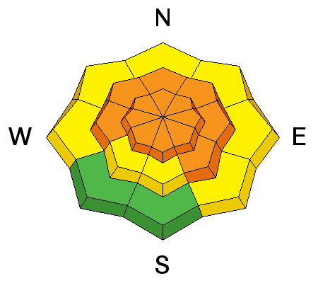
It's a tale of two snowpacks and they both have differant personalities. Where the pack is deep, avalanche concerns are pretty straight-forward and focus within the top layers of the snowpack. Last weeks light, fluffy storm snow is now capped with a strengthening slab along with Wednesday's storm. Once triggered, today's avalanches can break a couple feet deep, failing on the new snow/old snow interface. Don't under estimate these avalanches, they're packing a punch and could easily ruin your day. Sounds easy enough.... right? Well, not so straight-forward and much trickier are avalanches that break to the ground. Slopes that avalanched big during the Solstice Storm, left behind a weak, shallow snowpack and now we've stacked strong, cohesive snow on top. It's a lot like an early season snowpack and with all the additional snow, water, and wind we've piled on top, we're at a critical point in the snowpacks existence. Sure, alot of steep terrain avalanched during the height of Wednesday's storm, however, many steep mid and upper elevation slopes facing the north half of the compass just need a trigger like us to come along and knock the legs out from under the slab. Any avalanche that breaks to the ground will leave you feeling like you went 10 rounds with Holly Holm... yup, you're gonna get your butt handed to you. So with all this complexity how do we ride safely? It's actually pretty basic... simply steer clear of steep wind drifted slopes, especially terrain that faces the north half of the compass. Slopes that avalanched to the ground during the Solstice Storm are thin and weak and remain guilty until proven otherwise.
Big differance is snowpack depth, strength, and stability. JG's pit from yesterday clearly illustrates our current setup. More on his travels found here. Where the snowpack is deep, shears breaking to weak snow near the ground are getting ragged and lack energy, suggesting a turn towards stronger snow.
|
 |
weather High clouds drift into the region and temperatures warm into the upper 30's. Winds remain light and southerly, blowing in the teens and low 20's. Clouds thicken overnight and into Saturday as the next storm slides into the area. Snow develops late Saturday and continues through Sunday.
|
| general announcements Remember your information can save lives. If you see anything we should know about, please participate in the creation of our own community avalanche advisory by submitting snow and avalanche conditions. You can call me directly at 801-231-2170, email [email protected], or email by clicking HERE This is a great time of year to schedule a free avalanche awareness presentation for your group or club. You can contact me at 801-231-2170 or email [email protected]. To register for the first in our series of on-the-snow sled specific classes you can register here. The information in this advisory is from the US Forest Service which is solely responsible for its content. This advisory describes general avalanche conditions and local variations always occur. The information in this advisory expires 24 hours after the date and time posted, but be will be updated by 7:00 AM on Saturday, January 23rd.
|
Advisory Hotline: (888) 999-4019 | Contact Information