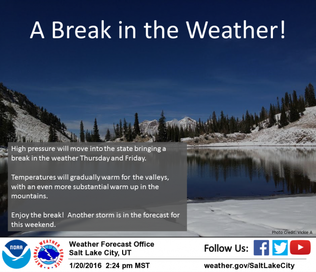
| Please join us at the 23rd annual Black Diamond Fall Fundraiser Party Thursday Sept 15. Tickets are on sale now here, at the Black Diamond store & at REI. Special bonus raffle for online ticket purchasers! |
| Please join us at the 23rd annual Black Diamond Fall Fundraiser Party Thursday Sept 15. Tickets are on sale now here, at the Black Diamond store & at REI. Special bonus raffle for online ticket purchasers! |
| Advisory: Uintas Area Mountains | Issued by Craig Gordon for Thursday - January 21, 2016 - 4:35am |
|---|

|
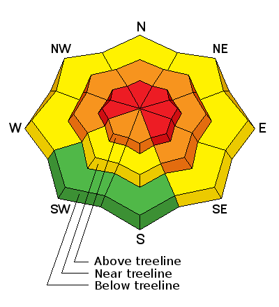
bottom line In the wind zone, at and above treeline, a HIGH avalanche danger exists. Human triggered avalanches are likely on steep, wind drifted slopes, especially those that face the north half of the compass, and particularly on slopes with an easterly component to their aspect. Any avalanche that breaks to weak, sugary snow near the ground will be deep and dangerous. At treeline, in steep, mid elevation terrain, a CONSIDERABLE avalanche danger is found and human triggered avalanches are probable on steep slopes with recent deposits of wind drifted snow. Even low elevation terrain is getting in on the act and you'll find a MODERATE avalanche danger on steep, wind drifted slopes and human triggered avalanches are possible. Looking for LOW avalanche danger? Simply avoid being on or under steep wind drifted slopes. You can have a blast carving deep trenches in big, open meadows or go for turns in wind sheltered, low angle terrain.
|
 |
avalanche warning THE FOREST SERVICE UTAH AVALANCHE CENTER IN SALT LAKE CITY HAS CONTINUED A BACKCOUNTRY AVALANCHE WARNING. * TIMING…IN EFFECT FROM 6 AM MST THIS MORNING TO 6 AM MST FRIDAY * AFFECTED AREA…FOR THE MOUNTAINS OF NORTHERN AND CENTRAL UTAH AND SOUTHEASTERN IDAHO INCLUDING THE WASATCH RANGE...BEAR RIVER RANGE...WESTERN UINTA RANGE...AND MANTI-SKYLINE PLATEAU. * AVALANCHE DANGER…THE AVALANCHE DANGER IS HIGH TODAY. * IMPACTS…VERY DANGEROUS AVALANCHE CONDITIONS EXIST. MANY AVALANCHES HAVE OCCURRED OVER THE LAST TWO DAYS AND MORE ARE LIKELY TODAY DUE TO RECENT SNOWFALL AND STRONG WINDS. STAY OFF OF AND OUT FROM UNDER SLOPES STEEPER THAN 30 DEGREES. |
 |
current conditions Wow, yesterday's storm slammed into the region like a cross-fire hurricane... thanks Glimmer Twins. Ripping ridgetop winds, heavy snow, and even a bolt or two of lightening made its presence known. In its wake, skies are clear, there's close to a foot of new snow, northwest winds are blowing 10-20 mph along the ridges, and temperatures are just cracking into the teens. It'll be an epic day of riding and wind sheltered terrain is gonna be the big ticket item. Trip reports and observations are found here.
|
 |
recent activity Yeah it's tricky... since Sunday there have been lots of avalanches, a number of close calls, and a few partial and full burials both in our hood and in neighboring mountains with snowpack structure similar to ours.
Manageable avalanche in Duke Cirque breaking within the new storm snow yesterday. (Janulaitis photo) Ob from that zone is found here.
Not so manageable avalanche breaking to weak Solstice snow near the ground on Sunday. Recent avalanche observations are found here. See or trigger an avalanche? Shooting cracks? Hear a collapse? It's simple. Go here to fill out an observation.
|
| type | aspect/elevation | characteristics |
|---|

|
|
LIKELIHOOD
 LIKELY
UNLIKELY
SIZE
 LARGE
SMALL
TREND
 INCREASING DANGER
SAME
DECREASING DANGER
|
|
description
It's a tale of two snowpacks and they both have differant personalities. Where the pack is deep, avalanche concerns are pretty straight-forward and focus within the top layers of the snowpack. Last weeks light, fluffy storm snow is now capped with a strengthening slab along with yesterdays storm. Once triggered, today's avalanches can break a couple feet deep, failing on the new snow/old snow interface. Don't under estimate these avalanches, they're packing a punch and could easily ruin your day. Sounds easy enough.... right? Well, not so straight-forward and much trickier are avalanches that break to the ground. Slopes that avalanched big during the Solstice Storm, left behind a weak, shallow snowpack and now we've stacked strong, cohesive snow on top. It's a lot like an early season snowpack and with all the additional snow, water, and wind we've piled on top, we're at a critical point in the snowpacks existence. Sure, alot of steep terrain avalanched during the height of yesterday's storm, however, many steep mid and upper elevation slopes facing the north half of the compass just need a trigger like us to come along and knock the legs out from under the slab. Any avalanche that breaks to the ground will leave you feeling like you went 10 rounds with Holly Holm... yup, you're gonna get your butt handed to you. So with all this complexity how do we ride safely? It's actually pretty basic... simply steer clear of steep wind drifted slopes, especially terrain that faces the north half of the compass. Slopes that avalanched to the ground during the Solstice Storm are thin and weak and remain guilty until proven otherwise.
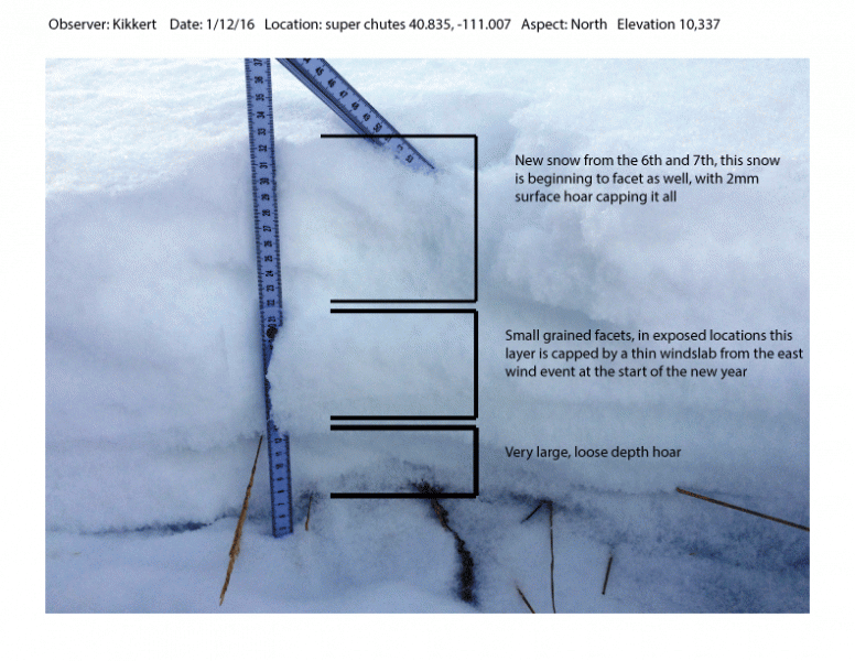
Big differance is snowpack depth, strength, and stability. JG's pit from yesterday clearly illustrates our current setup. More on his travels found here. Where the snowpack is deep, shears breaking to weak snow near the ground are getting ragged and lack energy, suggesting a turn towards stronger snow.
|
 |
weather It'll be a beautiful day in the mountains with clear skies, northwest winds in the teens, and temperatures climbing into the upper 20's. Overnight lows in the teens are a good bet. Friday brings partly cloudy skies, even warmer temperatures, and an increase in southwest winds. Clouds thicken Saturday and another storm is slated for Sunday.
|
| general announcements Remember your information can save lives. If you see anything we should know about, please participate in the creation of our own community avalanche advisory by submitting snow and avalanche conditions. You can call me directly at 801-231-2170, email [email protected], or email by clicking HERE This is a great time of year to schedule a free avalanche awareness presentation for your group or club. You can contact me at 801-231-2170 or email [email protected]. To register for the first in our series of on-the-snow sled specific classes you can register here. The information in this advisory is from the US Forest Service which is solely responsible for its content. This advisory describes general avalanche conditions and local variations always occur. The information in this advisory expires 24 hours after the date and time posted, but be will be updated by 7:00 AM on Friday, January 22nd.
|


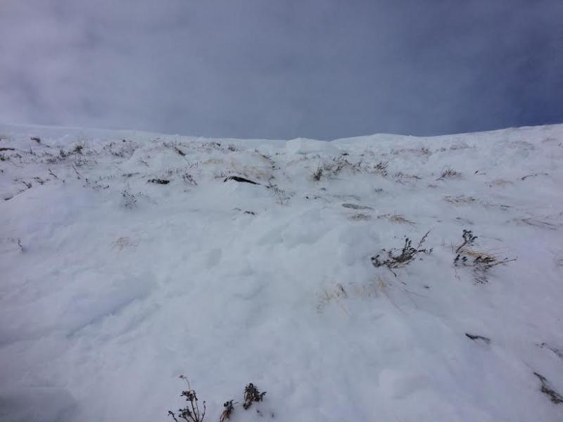
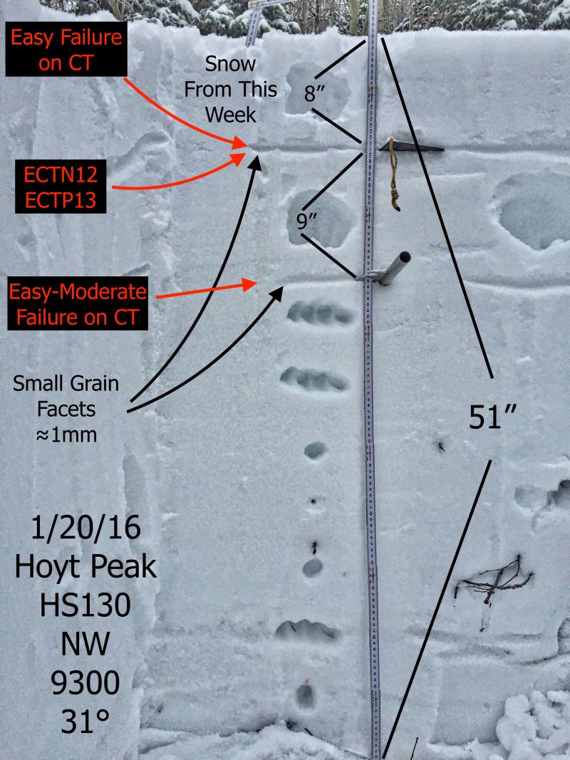
 Where the snowpack is shallow, it's a weak sugary mess. This snowpit is from a slope that avalanched during the Solstice Storm. Now a strong slab rests on top of this gong show, adding a layer of complexity to our current snowpack setup.