| Please join us at the 23rd annual Black Diamond Fall Fundraiser Party Thursday Sept 15. Tickets are on sale now here, at the Black Diamond store & at REI. Special bonus raffle for online ticket purchasers! |
| Please join us at the 23rd annual Black Diamond Fall Fundraiser Party Thursday Sept 15. Tickets are on sale now here, at the Black Diamond store & at REI. Special bonus raffle for online ticket purchasers! |
| Advisory: Uintas Area Mountains | Issued by Craig Gordon for Saturday - January 16, 2016 - 4:21am |
|---|

|
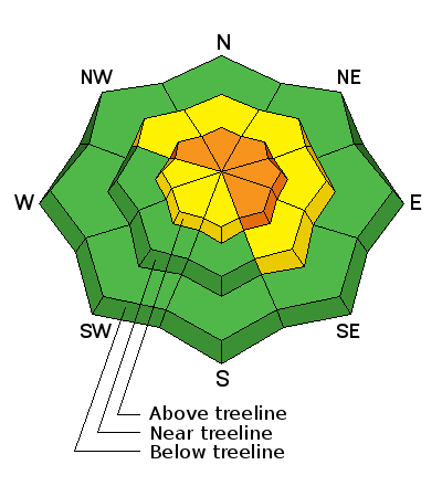
bottom line In the wind zone, particularly above treeline, a CONSIDERABLE avalanche danger exists and human triggered avalanches are likely on steep, wind drifted slopes, especially those that face the north half of the compass. Any slide that breaks to old snow near the ground will be deep and dangerous. At treeline, in steep, mid elevation terrain, a MODERATE avalanche danger is found and human triggered avalanches are possible on steep slopes with recent deposits of wind drifted snow. Lose the wind and you'll lose the problem. A LOW avalanche danger exists at lower elevations, particularly in wind sheltered terrain.
|
 |
avalanche watch THE FOREST SERVICE UTAH AVALANCHE CENTER IN SALT LAKE CITY HAS ISSUED A BACKCOUNTRY AVALANCHE WATCH. * TIMING…IN EFFECT FROM 6 AM MST THIS MORNING TO 6 AM MST SUNDAY * AFFECTED AREA…ALL THE MOUNTAINS OF NORTHERN AND CENTRAL UTAH AND SOUTHEASTERN IDAHO, TO INCLUDE THE WASATCH RANGE, THE BEAR RIVER RANGE, THE WESTERN UINTA RANGE AND THE MANTI-SKYLINE PLATEAU. * AVALANCHE DANGER…THE AVALANCHE DANGER WILL BE RISING TO HIGH TODAY . * IMPACTS…WIDESPREAD WEAK SNOW EXISTS UNDER NEW SNOW FROM THE LAST 48 HOURS. INCREASING WINDS WILL MAKE NATURAL AND HUMAN TRIGGERED AVALANCHES MORE LIKELY AS THE DAY PROGRESSES. THE AVALANCHE DANGER WILL BE RISING. BACKCOUNTRY TRAVELERS SHOULD CONSULT WWW.UTAHAVALANCHECENTER.ORG OR CALL 1-888-999-4019 FOR MORE DETAILED INFORMATION. THIS WATCH DOES NOT APPLY TO SKI AREAS WHERE AVALANCHE HAZARD REDUCTION MEASURES ARE PERFORMED. |
 |
current conditions The Uinta's are doing quite well with the recent series of small storms. In the past 24 hours another 4"-6" stacked up on the North Slope, with about half that amount the further south you travel. This morning, skies are mostly cloudy and temperatures in the mid teens. Westerly winds starting ramping up around midnight, blowing steadily in the 30's and 40's. While recent winds are starting to have their way in the big open bowls, lose some elevation and you'll be treated to deep, cold snow.
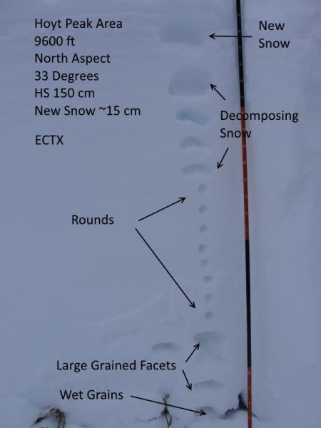
Micheal Janulaitis found mostly stable conditions around Hoyt Peak yesterday. Above is his well documented pit profile illustrating the current snowpack setup in that zone. Trip reports and observations are found here.
|
 |
recent activity
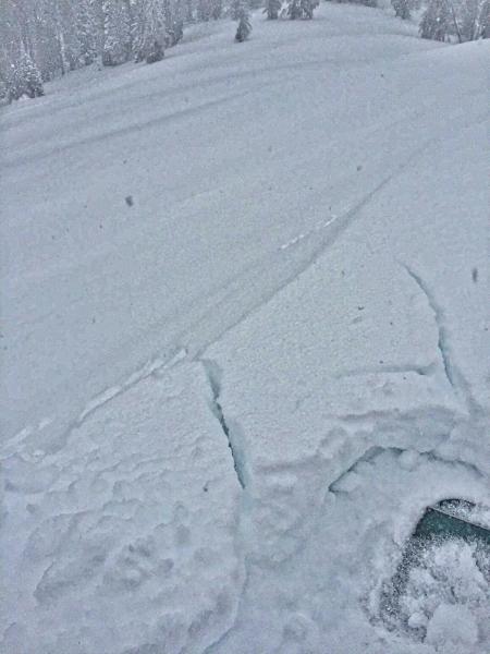
Yesterday's winds formed sensitive, yet fairly predictable drifts along the leeward side of upper elevation ridges. (JG Photo) Recent avalanche observations are found here. See or trigger an avalanche? Shooting cracks? Hear a collapse? It's simple. Go here to fill out an observation. |
| type | aspect/elevation | characteristics |
|---|

|

|
LIKELIHOOD
 LIKELY
UNLIKELY
SIZE
 LARGE
SMALL
TREND
 INCREASING DANGER
SAME
DECREASING DANGER
|
|
description
Winds are starting to crank and there's no shortage of light density snow to blow around. With heavier, wind driven snow in the forecast, this morning's predictable wind drifts might begin to break wider and deeper than you'd expect, and by days end I bet they're packing a punch. Remember- even a small slide can quickly get out of hand if it carries you over a cliff or slams you into a group of trees. Found mostly on the leeward side of upper elevation ridges, I wouldn't be surprised to discover a rogue drift or two lurking in a steep chute or gully. The ticket to riding safely today is looking for and avoiding any fat, rounded piece of snow, especially if it sounds hollow like a drum.
Yesterday's shallow soft slabs predictably broke at or below your skis, board, or sled. With winds forecast to crank later today and tonight, I suspect today's avalanche conditons will become less manageable as the day wears on. It doesn't mean you can't ride, it does mean you should think about avoiding steep slopes with recent depsotis of wind drifted snow. (JG Photo)
|
 |
weather Our active weather pattern remains in place and today we can expect mostly cloudy skies, temperatures rising into the mid 20's, with snow developing later this morning. Not a big storm... perhaps 6" by Sunday morning. The big news is the wind. Along the high ridges west and northwest winds increase throughout the day, blowing in the 30's and 40's with gusts in the 50's and 60's by about midnight. Clearing skies for Sunday with another round of snow slated to arrive Monday.
|
| general announcements Remember your information can save lives. If you see anything we should know about, please participate in the creation of our own community avalanche advisory by submitting snow and avalanche conditions. You can call me directly at 801-231-2170, email [email protected], or email by clicking HERE This is a great time of year to schedule a free avalanche awareness presentation for your group or club. You can contact me at 801-231-2170 or email [email protected]. To register for the first in our series of on-the-snow sled specific classes you can register here. The information in this advisory is from the US Forest Service which is solely responsible for its content. This advisory describes general avalanche conditions and local variations always occur. The information in this advisory expires 24 hours after the date and time posted, but be will be updated by 7:00 AM on Sunday, January 17th.
|