| Please join us at the 23rd annual Black Diamond Fall Fundraiser Party Thursday Sept 15. Tickets are on sale now here, at the Black Diamond store & at REI. Special bonus raffle for online ticket purchasers! |
| Please join us at the 23rd annual Black Diamond Fall Fundraiser Party Thursday Sept 15. Tickets are on sale now here, at the Black Diamond store & at REI. Special bonus raffle for online ticket purchasers! |
| Advisory: Uintas Area Mountains | Issued by Craig Gordon for Friday - January 15, 2016 - 4:28am |
|---|

|
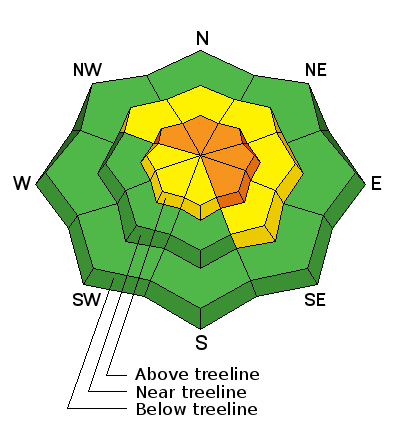
bottom line In the wind zone, particularly above treeline, a CONSIDERABLE avalanche danger exists and human triggered avalanches are likely on steep, wind drifted slopes, especially those that face the north half of the compass. Any slide that breaks to old snow near the ground will be deep and dangerous. At treeline, in steep, mid elevation terrain, a MODERATE avalanche danger is found and human triggered avalanches are possible on steep slopes with recent deposits of wind drifted snow. Lose the wind and you'll lose the problem. A LOW avalanche danger exists at lower elevations, particularly in wind sheltered terrain.
|
 |
current conditions Skies remained cloudy overnight, temperatures hovered in the low teens, and in the past 24 hours, 3"-6" of snow stacked up across the range. Southwest winds cranked in the 30's and 40's along the high peaks early Thursday, but mellowed into the 20's and low 30's overnight. In general, the snowpack is very supportable, travel is as easy as it gets, and great riding and turning conditions are found in mid elevation wind sheltered terrain. We're in a great pattern for free refills and the storms keep coming!
JG snapped this image of the burly winds pounding Longs Peak on Wednesday. Trip reports and observations are found here.
|
 |
recent activity
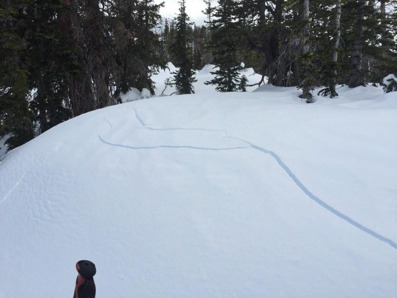
Sensitive drifts have formed a little lower down slope than you might expect. Shooting cracks like these in front of JG during his travels Wednesday are big clues to unstable snow.
Recent avalanche observations are found here. See or trigger an avalanche? Shooting cracks? Hear a collapse? It's simple. Go here to fill out an observation. |
| type | aspect/elevation | characteristics |
|---|

|

|
LIKELIHOOD
 LIKELY
UNLIKELY
SIZE
 LARGE
SMALL
TREND
 INCREASING DANGER
SAME
DECREASING DANGER
|
|
description
Since midday Wednesday, winds have been busy at work along the high ridges. With no shortage of light denstiy snow to blow around, fresh wind drifts are today's main avalanche concern. While found mostly on the leeward side of upper elevations ridges, I wouldn't be surprised to discover a rogue drift or two lurking in a steep chute or gully. Mostly manageable in size and depth and breaking at or below your skis, board, or sled, remember that even a small slide can quickly get out of hand if it carries you over a cliff or slams you into a group of trees. I'd continue to look for and avoid any fat, rounded piece of snow, especially if it sounds hollow like a drum.
|
 |
weather A quick hitting storm system slides through the region this morning, and should be out of the area late this afternoon. We can expect an additional 2"-4" inches of snow, with westerly winds in the 20's and 30's, perhaps a gust or two in the 40's along the highest ridges. Temperatures climb into the low 20's with overnight lows in the teens. A short-lived break is forecast for Saturday with a warm and windy storm slated for late Saturday afternoon through Sunday morning. |
| general announcements Remember your information can save lives. If you see anything we should know about, please participate in the creation of our own community avalanche advisory by submitting snow and avalanche conditions. You can call me directly at 801-231-2170, email [email protected], or email by clicking HERE This is a great time of year to schedule a free avalanche awareness presentation for your group or club. You can contact me at 801-231-2170 or email [email protected]. To register for the first in our series of on-the-snow sled specific classes you can register here. The information in this advisory is from the US Forest Service which is solely responsible for its content. This advisory describes general avalanche conditions and local variations always occur. The information in this advisory expires 24 hours after the date and time posted, but be will be updated by 7:00 AM on Saturday, January 16th by Craig Gordon.
|