| Please join us at the 23rd annual Black Diamond Fall Fundraiser Party Thursday Sept 15. Tickets are on sale now here, at the Black Diamond store & at REI. Special bonus raffle for online ticket purchasers! |
| Please join us at the 23rd annual Black Diamond Fall Fundraiser Party Thursday Sept 15. Tickets are on sale now here, at the Black Diamond store & at REI. Special bonus raffle for online ticket purchasers! |
| Advisory: Uintas Area Mountains | Issued by Craig Gordon for Wednesday - January 13, 2016 - 4:44am |
|---|

|
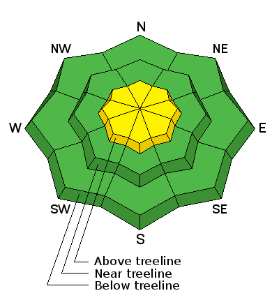
bottom line In the wind zone at and above treeline, a MODERATE avalanche danger exists and human triggered avalanches are possible on steep, wind drifted slopes, especially those that face the north half of the compass. Any slide that breaks to old snow near the ground will be deep and dangerous. You'll find a LOW avalanche danger at mid and lower elevations, particularly in wind sheltered terrain.
|
 |
current conditions Skies remained clear overnight and temperatures are a little inverted.... it's in the low 20's in Salt Lake City, same for along the ridges. Yesterday's northwest winds in the 20's and 30's mellowed just around midnight, switched to the southwest, and are currently blowing 10-20 mph along the high peaks. In general, the snowpack is very supportable, travel is as easy as it gets, and great riding and turning conditions are found in mid elevation wind sheltered terrain. Trip reports and observations are found here.
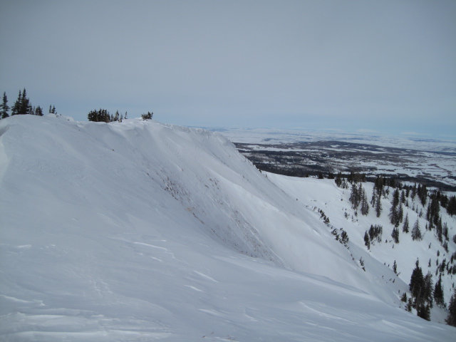
Ted was in the Moffit Basin yesterday and snapped this great scenic image. With the last day of high pressure on tap 'til about Sunday, it'll be a great day to explore these amazing mountains. (Scroggin photo)
|
 |
recent activity
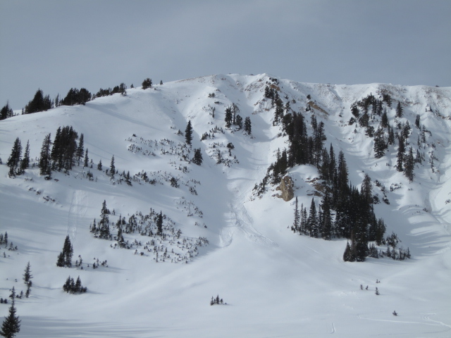
A couple shallow slabs were reported on the leeward side of upper elevation ridges, and they're definitely big enough to let you know who's boss, like this one on the east side of Moffit Peak. (Scroggin photo)
Recent avalanche observations are found here. See or trigger an avalanche? Shooting cracks? Hear a collapse? It's simple. Go here to fill out an observation. |
| type | aspect/elevation | characteristics |
|---|

|
|
LIKELIHOOD
 LIKELY
UNLIKELY
SIZE
 LARGE
SMALL
TREND
 INCREASING DANGER
SAME
DECREASING DANGER
|
|
description
Yesterday's west and northwest winds were able to find enough light density snow to blow around and whip into stiff drifts. While the vast majority of these relaxed overnight, I bet there's still a slab or two out there waiting for one of us to come along and test our stability theories. Found mostly on the leeward side of upper elevations ridges, I wouldn't be surprised to discover a rogue drift or two lurking in a steep chute or gully. While manageable in size and depth and breaking at or below your skis, board, or sled, remember that even a small slide can quickly get out of hand if it carries you over a cliff or slams you into a group of trees. I'd continue to look for and avoid any fat, rounded piece of snow, especially if it sounds hollow like a drum. Looking into the future. The snowpack on slopes that slid big during the Solstice storm is shallow and weak and won't take much of a load before we see avalanches. With a stormy pattern on tap beginning late tonight and continuing through the early portion of the weekend, today provides a good opportunity to take a look at some of your favorite riding areas and make note of terrain that avalanched near the ground back in December and slopes that remained intact. This exercize gives you an advantage once it starts storming and you'll have a pretty good idea what slopes to avoid.
With bushes and grass poking through a couple inches of snow, it's pretty obvious this steep slope slid pretty big during the Solstice storm. (Scroggin photo)
Dave Kikkert provided these excellent images. Top photo is the questionable structure we're finding in terrain where the snowpack is shallow, particularly on slopes that avalanched big right before Christmas. Above is a closeup of the weak, sugary snow we're concerned with once it starts snowing again.
|
| type | aspect/elevation | characteristics |
|---|

|

|
LIKELIHOOD
 LIKELY
UNLIKELY
SIZE
 LARGE
SMALL
TREND
INCREASING DANGER
SAME
DECREASING DANGER
|
|
description
The snowpack is pretty comfortable in its own skin and deep, dangerous avalanches are getting harder to trigger. As a matter of fact, it's been a few weeks since we've heard of or seen any slides breaking to the ground. While this suggests our snowpack is turning the corner towards stability, I'd still continue to carefully evaluate steep, upper elevation terrain, especially if it faces the north half of the compass, and particularly if it's thin and rocky. Any slide that breaks to old snow is gonna be deep and wide, quickly ruining your day, if not your season.
(Meisenheimer photo)
|
 |
weather One more sunny day is on tap with temperatures rising into the upper 30's. Winds stay relatively well behaved this morning, but should start to ramp up into the 30's and 40's later today. High pressure shifts east overnight allowing an active pattern to develop into the upcoming weekend. A small storm slides into the region tonight, followed by another one Thursday, with a good shot of snow expected early Friday. A foot of snow by Saturday morning seems like a pretty good bet. |
| general announcements Remember your information can save lives. If you see anything we should know about, please participate in the creation of our own community avalanche advisory by submitting snow and avalanche conditions. You can call me directly at 801-231-2170, email [email protected], or email by clicking HERE This is a great time of year to schedule a free avalanche awareness presentation for your group or club. You can contact me at 801-231-2170 or email [email protected]. To register for the first in our series of on-the-snow sled specific classes you can register here. The information in this advisory is from the US Forest Service which is solely responsible for its content. This advisory describes general avalanche conditions and local variations always occur. The information in this advisory expires 24 hours after the date and time posted, but be will be updated by 7:00 AM on Friday, January 15th by Craig Gordon.
|