| Please join us at the 23rd annual Black Diamond Fall Fundraiser Party Thursday Sept 15. Tickets are on sale now here, at the Black Diamond store & at REI. Special bonus raffle for online ticket purchasers! |
| Please join us at the 23rd annual Black Diamond Fall Fundraiser Party Thursday Sept 15. Tickets are on sale now here, at the Black Diamond store & at REI. Special bonus raffle for online ticket purchasers! |
| Advisory: Uintas Area Mountains | Issued by Trent Meisenheimer for Sunday - January 10, 2016 - 5:18am |
|---|

|
bottom line In the wind zone at and above treeline, a MODERATE avalanche danger exists and human triggered avalanches are possible on steep, wind drifted slopes, especially those that face the north half of the compass. Any slide that breaks to old snow near the ground will be deep and dangerous. You'll find a LOW avalanche danger at mid and lower elevations, particularly in wind sheltered terrain.
|
 |
current conditions Mostly cloudy skies this morning and mountain temperatures at the trail heads are in the single digits or just above. It will be a cold start to the day but should warm up nicely with great riding conditions. Winds continue to behave and tend to be out of the north with 11,000' speeds of 5-10 mph with gusts into the upper teens. We have picked up a trace to an inch of new snow in the past 24 hrs. Most of the popular areas you will find lots of tracks and riding conditions not so stellar. If you can get off the beaten path, soft powder and excellent boondocking does exist and riding conditions prove to be fun and floaty. The snow is very supportable and travel is as easy as it gets. Trip reports and observations are found here.
|
 |
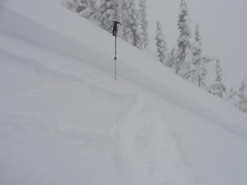
recent activity Friday a backcountry rider triggered a small soft slab avalanche on steep northwest facing slope at 10,500' in elevation. He was able to get away from the moving snow and was not caught or carried. The avalanche was 14'' deep and 30' wide (picture below). Also reported yesterday were sensitive new wind slabs just off the ridges in the more exposed terrain, these were small and manageable in size.
Photo: Michael Janulaitis Recent avalanche observations are found here. See or trigger an avalanche? Shooting cracks? Hear a collapse? It's simple. Go here to fill out an observation. |
| type | aspect/elevation | characteristics |
|---|

|

|
LIKELIHOOD
 LIKELY
UNLIKELY
SIZE
 LARGE
SMALL
TREND
 INCREASING DANGER
SAME
DECREASING DANGER
|
|
description
Though there's only an 5-8'' of fresh snow to work with, the recent winds formed sensitive, albeit shallow, wind drifts along the leeward side of upper elevation ridges. While mostly manageable in size and depth and predictably breaking at or below your skis, board, or sled, a manageable drift could get out of hand if it slams you into a group of trees or carries you over a cliff band. These wind slabs tend to stabilize within 24hrs but I would continue to approach steep wind drifted terrain with caution. Sled triggered wind slab from yesterday's field work, just south of Current Creek Peak. Mark Staples parks his sled next to the avalanche to check it out. (photo: Meisenheimer)
|
| type | aspect/elevation | characteristics |
|---|

|
|
LIKELIHOOD
 LIKELY
UNLIKELY
SIZE
 LARGE
SMALL
TREND
INCREASING DANGER
SAME
DECREASING DANGER
|
|
description
The slab is starting to relax and becoming progressively harder and harder to trigger each day. However, weak sugary snow still exists on the ground with very strong snow on top, this is a bad combo no matter how you cut it. This weak layer at the ground will become active again with new loads of snow and wind. The old bed surfaces where avalanches ran during the xmas cycle are still weak and faceted (sugary snow) and will likely re-load and avalanche again with future storms. Field Day Uinta Mountains 1 - 7- 2016 from Trent Meisenheimer on Vimeo. While this suggests our snowpack is turning the corner towards stability, I'd still continue to carefully evaluate any steep, upper elevation terrain, especially if it faces the north half of the compass, and particularly if it's thin and rocky. Any slide that breaks to old snow is gonna be deep and wide, quickly ruining your day, if not your season.
|
 |
weather A weak storm system will cross northern Utah today ushering in a few snow flurries and a small chance for measurable snow. Temperatures will climb into the mid 20's with clearing and very cold temperatures tonight. Winds are forecasted to be calm and out of the northwest with speeds less than 25 mph even in the highest of terrain. Ridging and high pressure moves into the state later today and we will see warming temperatures on Monday with no storms for the next few days. |
| general announcements Remember your information can save lives. If you see anything we should know about, please participate in the creation of our own community avalanche advisory by submitting snow and avalanche conditions. You can call me directly at 801-231-2170, email [email protected], or email by clicking HERE This is a great time of year to schedule a free avalanche awareness presentation for your group or club. You can contact me at 801-231-2170 or email [email protected]. To register for the first in our series of on-the-snow sled specific classes you can register here. The information in this advisory is from the US Forest Service which is solely responsible for its content. This advisory describes general avalanche conditions and local variations always occur. The information in this advisory expires 24 hours after the date and time posted, but be will be updated by 7:00 AM on Monday, January 11th by Craig Gordon.
|