| Please join us at the 23rd annual Black Diamond Fall Fundraiser Party Thursday Sept 15. Tickets are on sale now here, at the Black Diamond store & at REI. Special bonus raffle for online ticket purchasers! |
| Please join us at the 23rd annual Black Diamond Fall Fundraiser Party Thursday Sept 15. Tickets are on sale now here, at the Black Diamond store & at REI. Special bonus raffle for online ticket purchasers! |
| Advisory: Uintas Area Mountains | Issued by Craig Gordon for Sunday - January 3, 2016 - 6:44am |
|---|

|
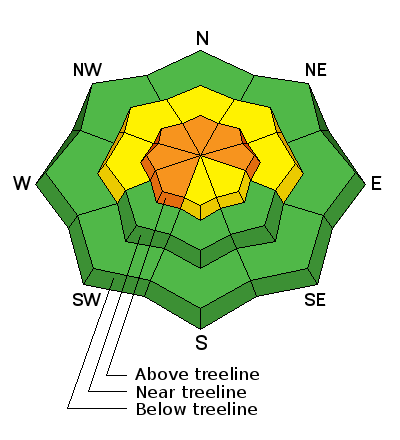
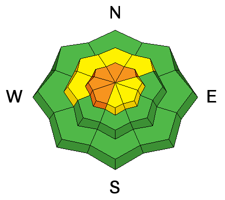
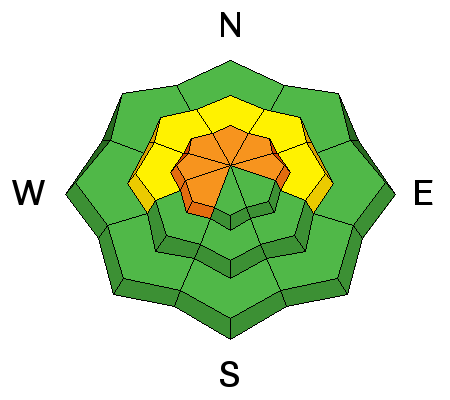
bottom line In the wind zone at and above treeline, a CONSIDERABLE avalanche danger exists and human triggered avalanches are likely on steep, wind drifted slopes, especially those that face the north half of the compass. Any slide that breaks to old snow near the ground will be deep and dangerous. Mid elevation terrain offers MODERATE avalanche danger and human triggered avalanches are possible on steep slopes with recent deposits of wind drifted snow. You'll find a LOW avalanche danger at lower elevations, particularly on slopes facing the south half of the compass.
|
 |
special announcement To the family we met at Nobletts Parking Lot earlier this week (James, Jenni, and Josh)... here's the link to register for our January sled specific avy awareness class. |
 |
current conditions We’re out of the deep freeze as a blanket of clouds overnight allowed temperatures to moderate somewhat. Currently it’s in the low 30’s at the trailheads and 20’s along the ridges. It’s calm down low, but along the high peaks Southerly winds continue to blow in 20’s and 30’s. The strong winds have jacked some of our big, open terrain and upper elevation bowls. Mid and lower elevation terrain is going to be the ticket today for soft settled powder Trip reports and observations are found here.
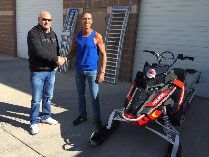
A big shout out and huge thanks to both Tri-City Performance in partnership with Polaris and Weller's Recreation in partnership with BRP Ski-Doo for their generous support, providing loaner sleds to the Avy Center each season. Their partnerships help us see more terrain, issue more accurate advisories, and ultimately save more lives.
|
 |
recent activity
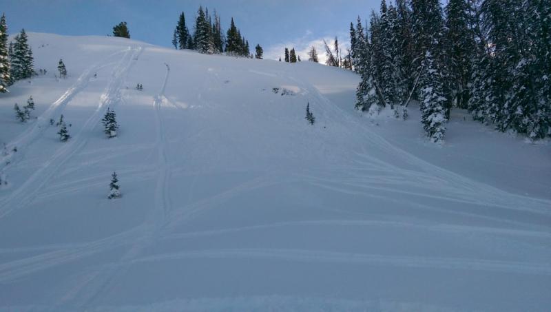
Averaging two feet deep, this fresh wind slab was triggered yesterday on a steep north facing slope near Hoyt Peak. Thanks Deven for the great image and info! Recent avalanche observations are found here. See or trigger an avalanche? Shooting cracks? Hear a collapse? It's simple. Go here to fill out an observation. |
| type | aspect/elevation | characteristics |
|---|

|
|
LIKELIHOOD
 LIKELY
UNLIKELY
SIZE
 LARGE
SMALL
TREND
 INCREASING DANGER
SAME
DECREASING DANGER
|
|
description
Winds are the big news and they’ve been busy at work along the ridges the past two days. There’s no shortage of light snow available to blow around and form drifts sensitive to the additional weight of a rider, and today you’ll find these fresh slabs not only on the on the leeward side of upper elevation ridges, but also cross-loaded in terrain features like chutes and gullies. Easy to detect by their fat, rounded appearance, today’s slabs may break deeper and wider than you might expect and could knock you off your skis, board, or sled.
|
| type | aspect/elevation | characteristics |
|---|

|
|
LIKELIHOOD
 LIKELY
UNLIKELY
SIZE
 LARGE
SMALL
TREND
INCREASING DANGER
SAME
DECREASING DANGER
|
|
description
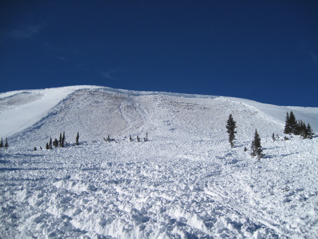
Less obvious and certainly more insidious is the possibility of triggering an avalanche that breaks to old, weak, sugary layers of snow near the ground. It's a bit complicated now because you can probably ride plenty of steep slopes and not trigger a slide and think you're good to go. However, the kind of avalanche dragon we're dealing with- DEEP SLABS- often lets you get well out onto the slope before you find a weakness in the pack, collapse the slope, and then BOOM... or in this case WHOOMPH, you're staring down the barrel of a very dangerous slide. Wanna get in on the powder party and not worry about avalanches? It's easy.... tone down your slope angles or simply boondock in the trees and meadows far away from anything steep.
You definitely don't want to be on the receiving end of a deep, dangerous slide like this avalanche, triggered low on the slope last Saturday, while a group of sledders were side-hilling. |
 |
weather High clouds drift in and out of the region today and temperatures rise into the mid 30’s before dipping into the low 20’s overnight. Southerly winds remain a nuisance, blowing 15-25 mph with a few gusts in the 40’s along the high peaks. A series of moist, but rather weak systems slides through the region tomorrow through the end of the week. Best chance for measurable snow comes in the Wednesday/Thursday timeframe. Not a big storm, but should be good for a fresh coat of white paint. |
| general announcements Remember your information can save lives. If you see anything we should know about, please participate in the creation of our own community avalanche advisory by submitting snow and avalanche conditions. You can call me directly at 801-231-2170, email [email protected], or email by clicking HERE This is a great time of year to schedule a free avalanche awareness presentation for your group or club. You can contact me at 801-231-2170 or email [email protected]. To register for the first in our series of on-the-snow sled specific classes you can register here. The information in this advisory is from the US Forest Service which is solely responsible for its content. This advisory describes general avalanche conditions and local variations always occur. The information in this advisory expires 24 hours after the date and time posted, but be will be updated by 7:00 AM on Wednesday, January 6th by Craig Gordon.
|