| Please join us at the 23rd annual Black Diamond Fall Fundraiser Party Thursday Sept 15. Tickets are on sale now here, at the Black Diamond store & at REI. Special bonus raffle for online ticket purchasers! |
| Please join us at the 23rd annual Black Diamond Fall Fundraiser Party Thursday Sept 15. Tickets are on sale now here, at the Black Diamond store & at REI. Special bonus raffle for online ticket purchasers! |
| Advisory: Uintas Area Mountains | Issued by Craig Gordon for Sunday - December 27, 2015 - 4:53am |
|---|


|
bottom line At mid and upper elevations at and above treeline, a CONSIDERABLE avalanche danger exists and human triggered avalanches are likely on steep, wind drifted slopes. Any slide that breaks to old snow near the ground will be deep, dangerous, and quite possibly, unsurvivable. Lower elevation terrain offers MODERATE avalanche danger and human triggered avalanches are possible on steep slopes with recent deposits of wind drifted snow. Looking for a place to ride today and avoid avalanches? Simply stick to low angle terrain with no steep slopes above or adjacent to where you're riding or choose big, wide open meadows where you can practice carving deep trenches.
|
 |
special avalanche bulletin THIS SPECIAL AVALANCHE ADVISORY IS FOR THE MOUNTAINS OF NORTHERN UTAH, TO INCLUDE SOUTHEAST IDAHO, THE BEAR RIVER RANGE, THE WASATCH RANGE, AND THE WESTERN UINTAS. HEAVY SNOW AND STRONG WINDS EARLIER THIS WEEK HAVE LED TO DANGEROUS AVALANCHE CONDITIONS WITH MANY AVALANCHES BREAKING TO THE GROUND. AVOID BEING ON OR BENEATH STEEP TERRAIN AS AVALANCHES MAY BE TRIGGERED FROM BELOW. |
 |
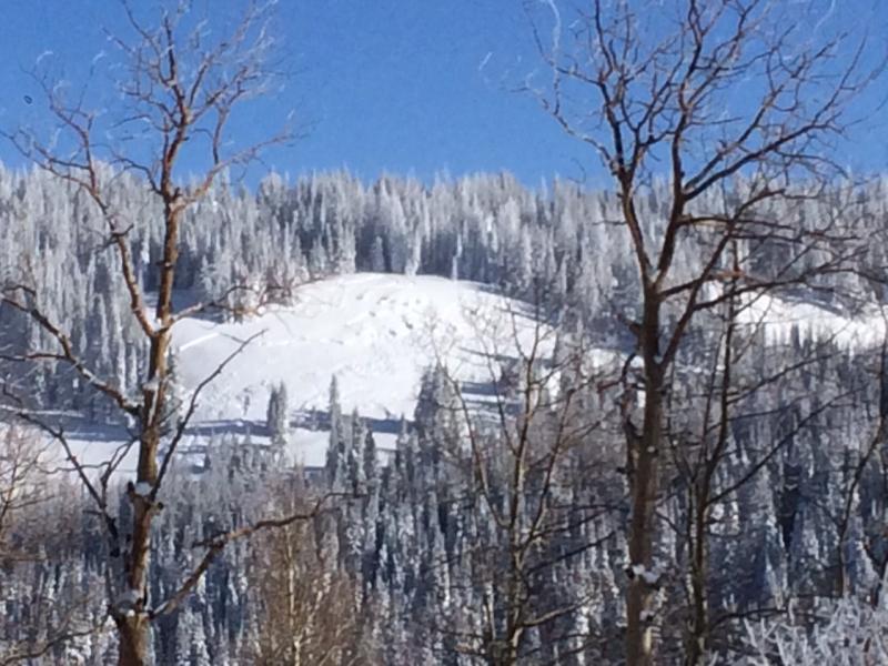
current conditions Skies remained clear overnight and winds are light, blowing just 5-15 mph along the high ridges. Temperatures are a bit inverted with the trailheads registering a face-numbing -10 to -15 degrees with the ridgeline temperatures just cracking into the double digts. Bet you'll quickly forget about the diesel gelling cold, 'cause the riding and turning conditions are all-time. Yep... it's in yer face and over-the-hood! Trip reports and observations are found here.
|
 |
recent activity
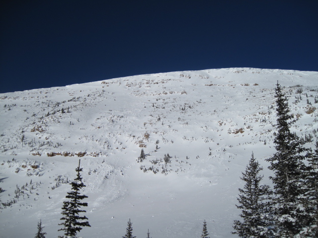
Dan Gardiner was riding yesterday in the Mill Hollow area and watched a group of sledders trigger this avalanche as they turned around at the top of the slope, near the top of the Little South Fork drainage. Drifted by yesterday's strong east and northeast winds and initially breaking 1'-2' deep, this avalanche quickly broke to weak snow near the ground as it crashed on the slope below.
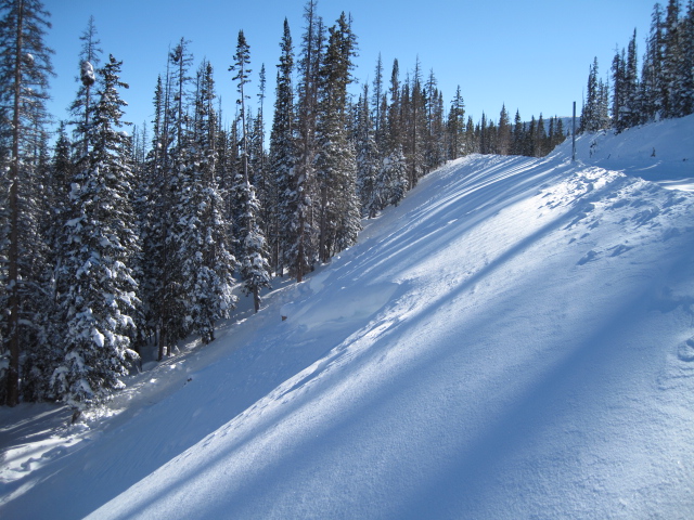
Ted braved a brutally cold start from the Bear River trailhead and reported some very impressive natural avalanches that can easily be seen along the Mirror Lake Highway. Nearly all the big terrain avalanched deep and wide and there were a couple surprises like this steep road bank triggered while the grooming cat made a pass. More on Ted's very informative take on the current state of avalanche affairs is found here. Recent avalanche observations are found here. See or trigger an avalanche? Shooting cracks? Hear a collapse? It's simple. Go here to fill out an observation. |
| type | aspect/elevation | characteristics |
|---|

|
|
LIKELIHOOD
 LIKELY
UNLIKELY
SIZE
 LARGE
SMALL
TREND
 INCREASING DANGER
SAME
DECREASING DANGER
|
|
description
Prior to the big Solstice storm, our snowpack was a weak sugary mess. In just a couple of days we added a tremendous amount of dense, wind driven, water laden snow, ontop of a fragile, shaky foundation. You probably wouldn't build your house on a structure like this and I'm sure not gonna bet my life on it. So here's the deal... much of the range slid naturally and there's reports of avalanches everywhere and that's good news. The bad news is, many slopes still hang in the balance waiting for a trigger like us to come along and tip the scales. Now comes the tricky part. You can probably ride plenty of steep slopes and not trigger a slide and think you're good to go. However, since it's pretty much been snowing and blowing all week, it'll gonna be hard to tell what slopes are intact and which have already avalanched. Unless you've got a keen eye or you've been carefully tracking a certain zone, your safest bet is to simply avoid steep slopes altogether. Click HERE to view a viddy that pretty much sums up what we're dealing with.
Not every slope you ride is gonna avalanche and that's going to complicate the overall picture. However, if you do find the right combination of terrain that remained intact during the big midweek storm, then add the additional weight of a rider to the slope, all you need to do is collapse the slope... whoomph... and you'll be staring down the barrel of a very dangerous avalanche similar to this close call which occurred Thursday in between Tower Mountain and Currant Creek Peak. Here is a great firsthand account, along with a viddy overview after the fact.
|
| type | aspect/elevation | characteristics |
|---|

|

|
LIKELIHOOD
 LIKELY
UNLIKELY
SIZE
 LARGE
SMALL
TREND
 INCREASING DANGER
SAME
DECREASING DANGER
|
|
description
East and northeast winds cranked into the 20's and upper 30's yesterday, blowing lots of light density snow around, forming wind slabs on slopes with a westerly component to their aspect. This is an unusual aspect for slabs to form on (usually this side of the compass is stripped by the wind), so you'll wanna look for and avoid any fat, rounded, piece of snow, especially if it sounds hollow like a drum. While today's slabs might not be quite as sensitive as yesterday, any slide triggered can quickly get out of hand if it breaks to old snow near the ground.
JG went out for a spin on his sled and caught this image of easterly winds transporting snow to the west facing slopes. More on his travels are found here. |
 |
weather High pressure remains over the region today, giving us mostly sunny skies, light winds, and temperatures rising into the upper teens and low 20's. Under partly cloudy skies tonight temperatures dip into the single digits. Winds shift to the southwest this afternoon and increase into the 20's and 30's through tomorrow, ahead of an approaching storm system. This relatively weak storm moves through the area late Monday through Tuesday, delivering a couple inches of snow. High pressure returns for the New Year.
|
| general announcements Remember your information can save lives. If you see anything we should know about, please participate in the creation of our own community avalanche advisory by submitting snow and avalanche conditions. You can call me directly at 801-231-2170, email [email protected], or email by clicking HERE This is a great time of year to schedule a free avalanche awareness presentation for your group or club. You can contact me at 801-231-2170 or email [email protected]. To register for the first in our series of on-the-snow sled specific classes you can register here. The information in this advisory is from the US Forest Service which is solely responsible for its content. This advisory describes general avalanche conditions and local variations always occur. The information in this advisory expires 24 hours after the date and time posted, but be will be updated by 7:00 AM on Monday, December 28th by Craig Gordon.
|