| Please join us at the 23rd annual Black Diamond Fall Fundraiser Party Thursday Sept 15. Tickets are on sale now here, at the Black Diamond store & at REI. Special bonus raffle for online ticket purchasers! |
| Please join us at the 23rd annual Black Diamond Fall Fundraiser Party Thursday Sept 15. Tickets are on sale now here, at the Black Diamond store & at REI. Special bonus raffle for online ticket purchasers! |
| Advisory: Uintas Area Mountains | Issued by Trent Meisenheimer for Wednesday - December 23, 2015 - 4:22am |
|---|

|
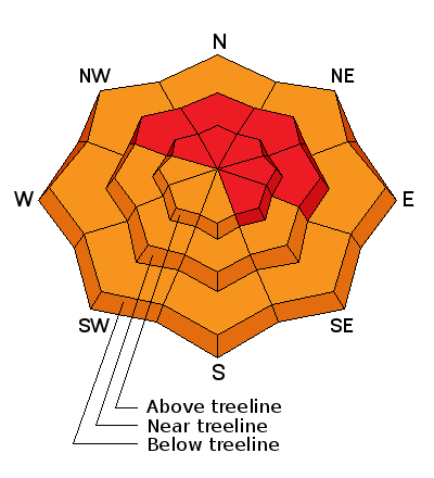
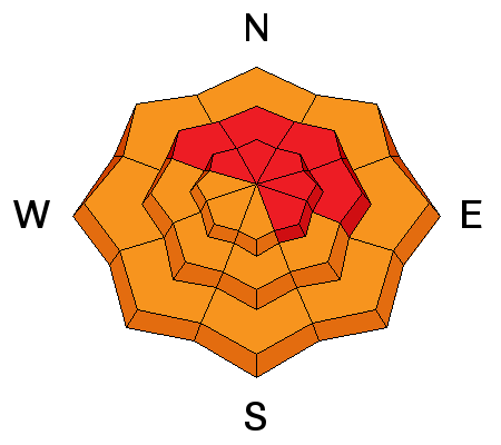
bottom line At mid and upper elevations at and above treeline, a HIGH avalanche danger exists, especially on steep, wind drifted terrain facing the north half of the compass. Both natural and human triggered avalanches are very likely, particularly on slopes with an easterly component to their aspect. Any slide triggered today will be deep, dangerous, and quite possibly, unsurvivable. Backcountry travel is not reccommonded.
|
 |
avalanche warning THE FOREST SERVICE UTAH AVALANCHE CENTER IN SALT LAKE CITY HAS ISSUED A BACKCOUNTRY AVALANCHE WARNING. * TIMING...IN EFFECT FROM 3:30 PM MST MONDAY TO 6 PM MST THURSDAY * AFFECTED AREA...ALL THE MOUNTAINS OF NORTHERN AND CENTRAL UTAH AND SOUTHEASTERN IDAHO TO INCLUDE THE WASATCH RANGE, THE BEAR RIVER RANGE, THE WESTERN UINTAS AND THE MANTI-SKYLINE PLATEAU. OTHER MOUNTAIN RANGES WILL LIKELY BE AFFECTED AS WELL * AVALANCHE DANGER...THE AVALANCHE DANGER FOR THE WARNING AREA IS HIGH * IMPACTS...HEAVY SNOWFALL COMBINED WITH STRONG WINDS IS CREATING WIDESPREAD AREAS OF UNSTABLE SNOW. BOTH HUMAN TRIGGERED AND NATURAL AVALANCHES ARE LIKELY AND WILL OCCUR IN MANY AREAS. STAY OFF OF AND OUT FROM UNDER SLOPES STEEPER THAN 30 DEGREES. |
 |
special announcement Very dangerous avalanche conditions exist and slides can be triggered not only on steep wind drifted slopes, but also low on the slope and from adjacent terrain. Once triggered, today's avalanches will break deep and wide, taking out the entire seasons snowpack. This is the exact type of setup that leads to avalanche accidents that always have a sad, devastating ending. |
 |
current conditions Wow, the first day of winter started with a bang. Snow totals are in the 20-30 inch range with roughly 2'' of water weight. Currently the wind is out of the northwest in the 5-15mph range gusting into 20's along the high peaks. Mountain temperatures at 8,000 ft are in the 20's and 10,000 ft temps are in the 15 degree range. The snow surface is all time with great riding conditions and 5 star powder. Trip reports and observations are found here.
|
 |
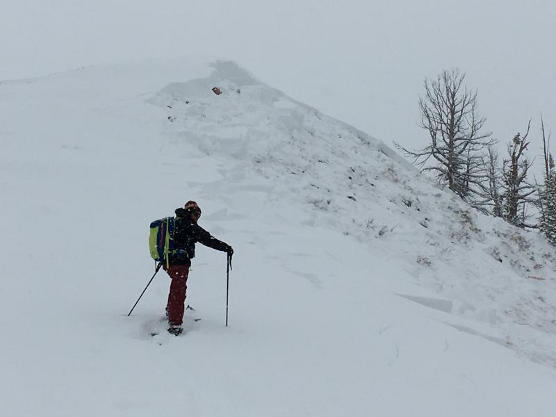
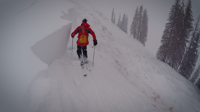
recent activity The Western Uinta snowpack was stretched to the breaking point yesterday. However, it did not appear to be a wide spread natural avalanche cycle, which is my mind makes conditions even more complicated. Most slopes are just patiently awaiting a trigger to come along tip the balance. Avalanches were triggered yesterday remotely (from a distance) from the flats or adjacent slopes. These avalanches were quite large with one being 1500 ft wide and averaging 3-5 ft deep. If the trauma of this type of avalanche doesn't kill you, being buried underneath feet of snow most likely will. Conditions remain very scary throughout the range. Pictures below are two avalanches remotely triggered yesterday by Craig Gordon and myself yesterday during our field day in upper Weber Canyon.
Recent avalanche observations are found here and a viddy recap of last weeks avalanche cycle is found here See or trigger an avalanche? Shooting cracks? Hear a collapse? It's simple. Go here to fill out an observation. |
| type | aspect/elevation | characteristics |
|---|

|
|
LIKELIHOOD
 LIKELY
UNLIKELY
SIZE
 LARGE
SMALL
TREND
 INCREASING DANGER
SAME
DECREASING DANGER
|
|
description
Frightening, terrifying, hair-raising, eerie, creepy, spooky, horrifying....Take your pic of the adjective that speaks to you most. We have lots of new wind driven snow over very weak snow near the ground. "It's kindergarden science, strong blocks stacked on weak blocks." This is no doubt a dangerous set up. Any avalanche triggered today will likely be devastating to you and your sled. Avalanche conditions will remain dangerous over the next several days, this doesn't mean you cant ride. What it does mean, is we need to avoid avalanche terrain all together. We need to stick to slopes under 30 deg in slope steepness with nothing steeper above or adjacent to us. Stick to simple terrain that will allow you success to come back home tonight. Simple means flat meadows and very low angle trees. One of our pro observers said it very well in his observation from yesterday " It can be difficult to make good decisions when the riding is SOOO good but the signs of a fragile snowpack are pretty obvious. Slope angle and good route finding is key right now." Photo - Craig Gordon checking out the crown of a large avalanche from yesterday.
|
 |
weather A winter storm warning remains in effect through 5pm today. Another disturbance will move swiftly east southeast across the region this morning followed by a cold and unstable northwest flow this afternoon and into tonight. We may pick up 3-6 inches of new snow today. Temperatures should remain mild, in the mid 20's and low 30's. Winds out of the south may pick up a bit before the passing of the cold front. Looks like we will remain under a northwest flow with scattered snow showers at times, high pressure builds towards the weekend.
|
| general announcements Remember your information can save lives. If you see anything we should know about, please participate in the creation of our own community avalanche advisory by submitting snow and avalanche conditions. You can call me directly at 801-231-2170, email [email protected], or email by clicking HERE This is a great time of year to schedule a free avalanche awareness presentation for your group or club. You can contact me at 801-231-2170 or email [email protected]. To register for the first in our series of on-the-snow sled specific classes you can register here. The information in this advisory is from the US Forest Service which is solely responsible for its content. This advisory describes general avalanche conditions and local variations always occur. The information in this advisory expires 24 hours after the date and time posted, but be will be updated by 7:00 AM on Thursday, December 24rd.
|