| Please join us at the 23rd annual Black Diamond Fall Fundraiser Party Thursday Sept 15. Tickets are on sale now here, at the Black Diamond store & at REI. Special bonus raffle for online ticket purchasers! |
| Please join us at the 23rd annual Black Diamond Fall Fundraiser Party Thursday Sept 15. Tickets are on sale now here, at the Black Diamond store & at REI. Special bonus raffle for online ticket purchasers! |
| Advisory: Uintas Area Mountains | Issued by Craig Gordon for Monday - December 21, 2015 - 4:18am |
|---|

|
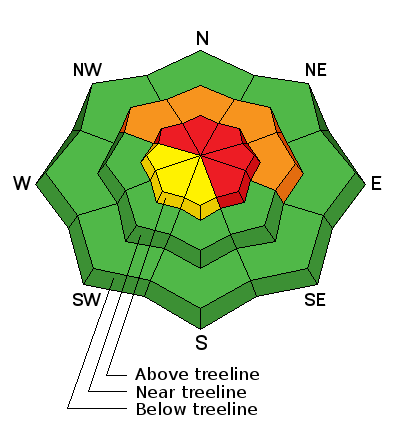
bottom line At and above treeline, a HIGH avalanche danger exists on steep, wind drifted terrain facing the north half of the compass. Human triggered avalanches are likely, particularly on slopes with an easterly component to their aspect. Any slide triggered today has the potential to break wider and deeper than you might expect, resulting in a dangerous avalanche. A CONSIDERABLE danger is found at mid elevations and human triggered avalanches are likely on steep, wind drifted slopes. Low elevations and terrain sheltered from the wind generally offers a LOW avalanche danger.
|
 |
avalanche watch HEADS UP- THE FOREST SERVICE UTAH AVALANCHE CENTER IN SALT LAKE CITY HAS ISSUED A BACKCOUNTRY AVALANCHE WATCH. AFFECTED AREA...ALL THE MOUNTAINS OF NORTHERN UTAH AND SOUTHEASTERN IDAHO, TO INCLUDE THE BEAR RIVER RANGE, THE WESTERN UINTAS AND THE MANTI-SKYLINE PLATEAU. * AVALANCHE DANGER...EXPECTED HEAVY SNOW AND STRONG WIND WILL PUSH THE DANGER TO HIGH AND PERHAPS EXTREME OVER THE NEXT SEVERAL DAYS. * IMPACTS...BY LATER TODAY INTO TUESDAY, LARGE AND DANGEROUS NATURAL AND HUMAN TRIGGERED AVALANCHES WILL BE LIKELY. AVOID BEING IN STEEP TERRAIN OR BENEATH AVALANCHE RUNOUT ZONES. |
 |
current conditions Yesterday's fast moving system delivered 4"-6" of light density snow across the range, with the North Slope and Mirror Lake Corridor squeaking out close to 8". Southwest winds ramped up around midnight and are blowing 30-50 mph along the high ridges. Temperatures are mild, in the low to mid 20's
With total snow depths in the 24"- 30" range, it's still pretty thin out there. Ted's travels took him to Lofty and Steiner Lakes on Saturday. His trip report as well as other observations are found here.
|
 |
recent activity
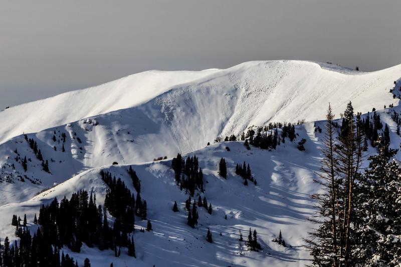
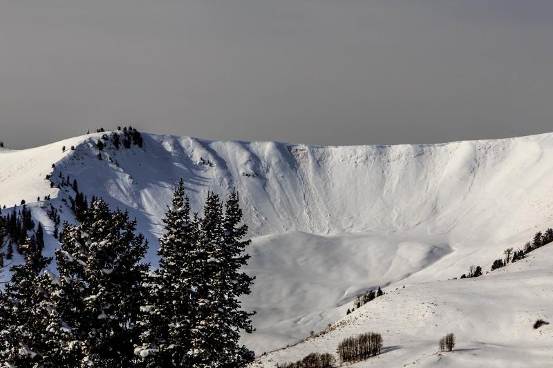
Beautiful avalanche photos above shot by Johnny Adolphson Our snowpack is fragile and last Wednesday night's raging winds tipped the scales, resulting in numerous avalanches breaking deep, wide, and to the ground. A quick viddy recap is found here Recent avalanche observations are found here. See or trigger an avalanche? Shooting cracks? Hear a collapse? It's simple. Go here to fill out an observation. |
| type | aspect/elevation | characteristics |
|---|

|
|
LIKELIHOOD
 LIKELY
UNLIKELY
SIZE
 LARGE
SMALL
TREND
 INCREASING DANGER
SAME
DECREASING DANGER
|
|
description
Winds ramped up overnight and our weak snowpack will struggle trying adjust to this rapid load. I don't suspect the range is coming unglued just yet, though I do think many slopes are teetering on the edge and probably need a trigger like us to come along and knock the legs out from underneath. The fact is, we've got a dangerous setup in our backcountry and today's avalaches are the take no prisoner, tree snapping variety. Strong snow on weak snow.... it feels bomber under our skis, board, or sled. However, we've got to remember to think about not only what we're riding in, but also what we're riding on. This is the type of setup that leads to avalanche incidents, close calls, and unfortunately avalanche accidents. It'll be spooky out there the next couple of days, but it doesn't mean you can't ride. Simply tone it down and stick with low angle terrain with no steep slopes above our adjacent to where you're rding.
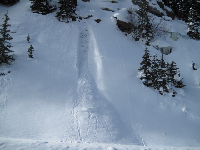
You call that an avalanche? Well, I guess technically it is... more importantly Ted snapped this image clearly illustratrating just how weak our current snowpack is.
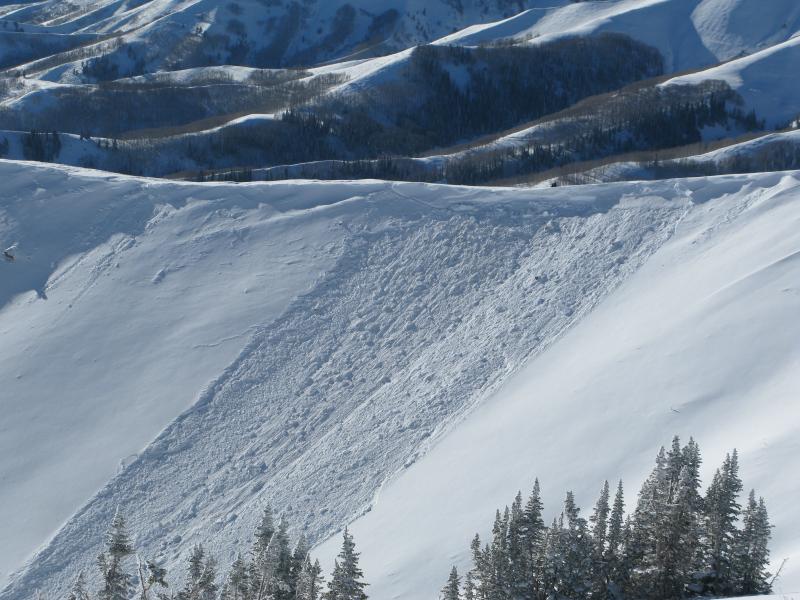
Now take that same weak snow, add some wind like we did Wednesday night, put a cohesive slab on top, and now you've got an avalanche.
JG was in Weber Canyon and found weak snow both in the midpack and at the ground. This is the setup we're dealing with this coming week.
|
 |
weather Snow continues this morning with a brief break in the action midday. Temperatures climb into the low 30's and southwest winds start cranking into the 50's and 60's this afternoon as the fire hose of Pacific moisture sets its sights on the northern half of the state. Heavy, high density snow and very strong winds are expected late this afternoon through tonight and into Tuesday morning. Colder air slides through the region and snow densities become lighter. This is a multi-day storm with a series of embedded impulses and should be a good snow producer for the eastern front.
|
| general announcements Remember your information can save lives. If you see anything we should know about, please participate in the creation of our own community avalanche advisory by submitting snow and avalanche conditions. You can call me directly at 801-231-2170, email [email protected], or email by clicking HERE This is a great time of year to schedule a free avalanche awareness presentation for your group or club. You can contact me at 801-231-2170 or email [email protected]. To register for the first in our series of on-the-snow sled specific classes you can register here. The information in this advisory is from the US Forest Service which is solely responsible for its content. This advisory describes general avalanche conditions and local variations always occur. The information in this advisory expires 24 hours after the date and time posted, but be will be updated by 7:00 AM on Tuesday, December 22nd.
|