| Please join us at the 23rd annual Black Diamond Fall Fundraiser Party Thursday Sept 15. Tickets are on sale now here, at the Black Diamond store & at REI. Special bonus raffle for online ticket purchasers! |
| Please join us at the 23rd annual Black Diamond Fall Fundraiser Party Thursday Sept 15. Tickets are on sale now here, at the Black Diamond store & at REI. Special bonus raffle for online ticket purchasers! |
| Advisory: Uintas Area Mountains | Issued by Craig Gordon for Wednesday - December 16, 2015 - 3:59am |
|---|

|
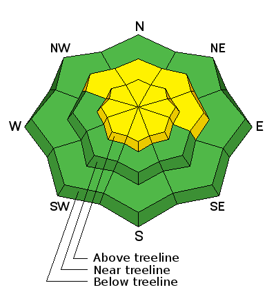
bottom line At and above treeline the avalanche danger is MODERATE and human triggered avalanches are possible. Any slide triggered today has the potential to break wider and deeper than you might expect creating a dangerous avalanche. Low elevations and terrain sheltered from the wind generally offers a LOW avalanche danger.
|
 |
current conditions Under mostly cloudy skies this morning, light snow is falling, adding an additional inch or two of low density fluff to Monday night's foot plus storm. West and northwest winds are blowing 15-25 mph along the high peaks and it's cold, barely cracking 0 degrees along the ridges and just inching into single digits at the trailheads.
The recent storms are helping to fill things in, but 30" of total snow depth doesn't negate 50" of total rock height. Yep... in general it's still low tide on the eastern front. Road rides or grassy meadows are still your best best to avoid a season ending injury to both yo body and yo sled.
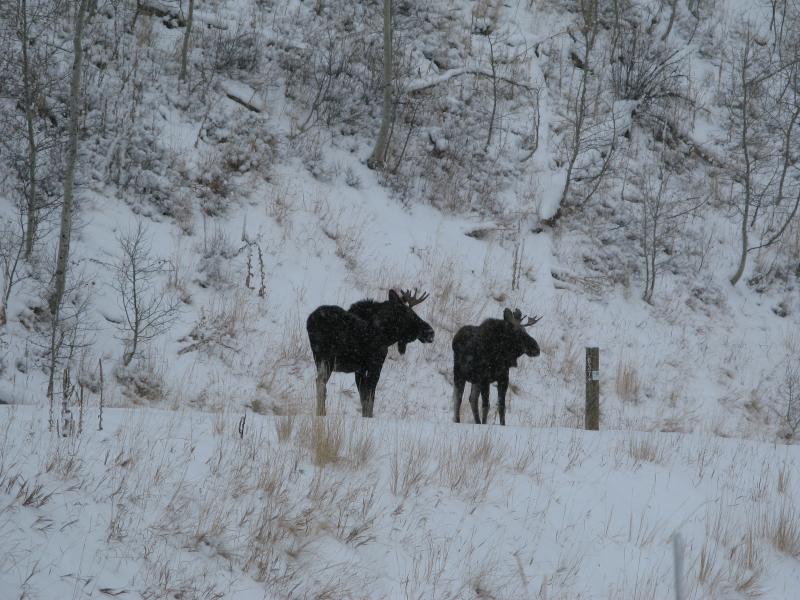
Ran into a couple of locals on the way out yesterday. These moose? Why yes, apparently they are loose Recent trip reports and observations are found here.
|
 |
recent activity No new avalanches have been reported from the backcountry.
JG got some cracking around his skis, but didn't see or trigger any avalanches during his travels to Lakes Country near the Mirror Lake Highway. More on his travels can be found here. See or trigger an avalanche? Shooting cracks? Hear a collapse? It's simple. Go here to fill out an observation. |
| type | aspect/elevation | characteristics |
|---|

|

|
LIKELIHOOD
 LIKELY
UNLIKELY
SIZE
 LARGE
SMALL
TREND
 INCREASING DANGER
SAME
DECREASING DANGER
|
|
description
Yesterday, I was on the south half of the range near Wolf Creek Pass where the snowpack has been pretty shallow and weak this season. While not a total shock, I was a little suprised just how well-behaved and unreactive the snowpack was, especially given some of the recent winds and new snow. While I didn't see any signs of instability, (no recent slides, cracking, or collapsing), the fact remains our snowpack has some structural issues, it just hasn't had a good thump of water weight to tip the scales. I also have to remember, the Uinta's are a big place and I just saw a postage sized portion of our terrain. That said.... given our current snowpack setup, I don't think I'd be diving into steep, wind drifted terrain facing the north half of the compass because the consequences of triggering even a small slide are gonna result in a season ending injury. And finally, I have to remind myself that the kind of avalanche dragon we're dealing with tends to be a bit tricky, but once triggered, a relitively manageable looking slide could quickly get out of hand as it breaks deeper into weak layers buried in the snowpack. The most likely place to encounter these conditions is going to be on slopes facing the north half of the compass at or above tree line. Remember- any slide that breaks to ground is going to reveal a nasty array of season ending obstacles.
Pit from near Wolf Creek Pass clearly illustrates the suspect structure of our current snowpack More on my travels here.
|
 |
weather We should see a little break in-between systems, but I can't rule out a flurry or two throughout the morning. Temperatures remain cold, only climbing into the teens before diving into the single digits overnight. Snow develops late in the day with an additional 3"-6" expected overnight, but west and northwest winds are gonna be a spoiler as they increase throughout the day, gusting into the 40's and 50's along the high peaks. Snow ends Thursday morning with a break and warming trend slated for Friday and Saturday and another round of snow on Sunday. Next week is lining up to be active in the weather department with a series of wet storms poised to slide into the region.
|
| general announcements Remember your information can save lives. If you see anything we should know about, please participate in the creation of our own community avalanche advisory by submitting snow and avalanche conditions. You can call me directly at 801-231-2170, email [email protected], or email by clicking HERE This is a great time of year to schedule a free avalanche awareness presentation for your group or club. You can contact me at 801-231-2170 or email [email protected]. To register for the first in our series of on-the-snow sled specific classes you can register here. The information in this advisory is from the US Forest Service which is solely responsible for its content. This advisory describes general avalanche conditions and local variations always occur. The information in this advisory expires 24 hours after the date and time posted, but be will be updated by 7:00 AM on Thursday, December 17th.
|