| Please join us at the 23rd annual Black Diamond Fall Fundraiser Party Thursday Sept 15. Tickets are on sale now here, at the Black Diamond store & at REI. Special bonus raffle for online ticket purchasers! |
| Please join us at the 23rd annual Black Diamond Fall Fundraiser Party Thursday Sept 15. Tickets are on sale now here, at the Black Diamond store & at REI. Special bonus raffle for online ticket purchasers! |
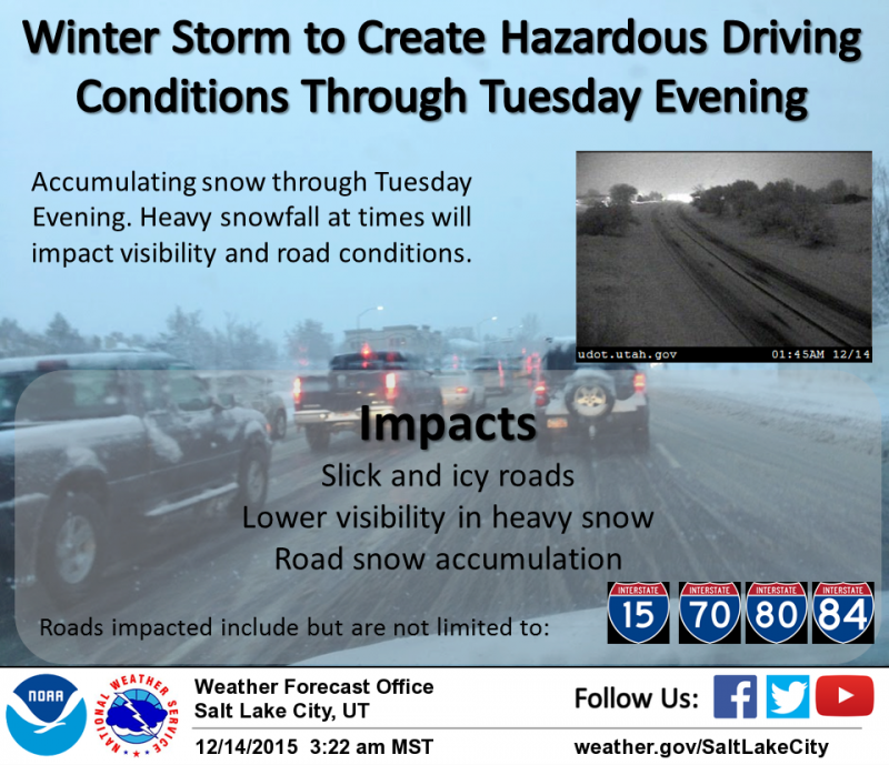
| Advisory: Uintas Area Mountains | Issued by Craig Gordon for Monday - December 14, 2015 - 3:58am |
|---|


|
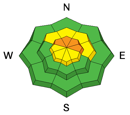
bottom line At and above treeline the avalanche danger is CONSIDERABLE and human triggered avalanches are likely. Any slide triggered today has the potential to break wider and deeper than you might expect creating a dangerous avalanche. A MODERATE avalanche danger is found on steep, wind drifted slopes at mid elevations and human triggered avalanches are possible. Low elevations and terrain sheltered from the wind generally offers a LOW avalanche danger.
|
 |
current conditions The storm is just getting underway and early morning snow totals are in the 3"-5" range. Southerly winds cranked into the 40's and 50's late last night, before mellowing into the 20's and 30's early this morning. It's crisp out there this morning with temperatures in the low to mid teens. The new snow is helping to fill things in, but the fact is, the range is still quite shallow. Road rides or grassy meadows are your best best to avoid a season ending injury to both yo body and yo sled. Check out Ted's excellent observation found here and his new video from Friday's field work in the Whitney Basin, clearly illustrating the pre-storm setup. GOPR0024 from ted scroggin on Vimeo. Recent trip reports and observations are found here.
|
 |
recent activity No new avalanches have been reported from the backcountry. See or trigger an avalanche? Shooting cracks? Hear a collapse? It's simple. Go here to fill out an observation. |
| type | aspect/elevation | characteristics |
|---|

|
|
LIKELIHOOD
 LIKELY
UNLIKELY
SIZE
 LARGE
SMALL
TREND
 INCREASING DANGER
SAME
DECREASING DANGER
|
|
description
Winds are busy at work, forming drifts that'll be sensitive to the additional weight of a rider today. It'll be blowing and snowing and visibilty might be an issue, but you'll want to look for and avoid any fat, rounded piece of snow, especially if it sounds hollow like a drum. The most likely place to encounter these conditions is going to be on slopes facing the north half of the compass at or above tree line. Any slide triggered has the potential to break deeper and wider than you might expect. wind slab from Trent Meisenheimer on Vimeo. Click here to view more Uinta observations and trip reports.
|
| type | aspect/elevation | characteristics |
|---|

|
|
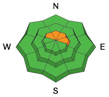
LIKELIHOOD
 LIKELY
UNLIKELY
SIZE
LARGE
SMALL
TREND
 INCREASING DANGER
SAME
DECREASING DANGER
|
|
description
As the snow stacks up and certainly if the winds continue to ramp up, avalanches have the potential to break to weak layers of snow near the ground. Avoiding steep, upper elevation terrain facing the north half of the compass is gonna be the ticket today.
|
 |
weather Snow, heavy at times throughout the day with additional accumulations in the 4"-8" range. Winds should switch from the south to the west and northwest this morning and remain pretty reasonable, in the 15-25 mph range with a few gusts in the mid 30's along the high ridges. Temperatures barely climb into the upper teens before crashing to near zero overnight. As cold air filters into the region another round of snow slides into the area late in the day giving us an additional 8"-10" of snow. Snow showers are expected on Tuesday, with the storm winding down late in the day.
Yep.... it's gonna storm, but getting to the trailhead is gonna be a challenge today.
|
| general announcements Remember your information can save lives. If you see anything we should know about, please participate in the creation of our own community avalanche advisory by submitting snow and avalanche conditions. You can call me directly at 801-231-2170, email [email protected], or email by clicking HERE This is a great time of year to schedule a free avalanche awareness presentation for your group or club. You can contact me at 801-231-2170 or email [email protected]. To register for the first in our series of on-the-snow sled specific classes you can register here. The information in this advisory is from the US Forest Service which is solely responsible for its content. This advisory describes general avalanche conditions and local variations always occur. The information in this advisory expires 24 hours after the date and time posted, but be will be updated by 7:00 AM on Tuesday, December 15th.
|