| Please join us at the 23rd annual Black Diamond Fall Fundraiser Party Thursday Sept 15. Tickets are on sale now here, at the Black Diamond store & at REI. Special bonus raffle for online ticket purchasers! |
| Please join us at the 23rd annual Black Diamond Fall Fundraiser Party Thursday Sept 15. Tickets are on sale now here, at the Black Diamond store & at REI. Special bonus raffle for online ticket purchasers! |
| Advisory: Uintas Area Mountains | Issued by Trent Meisenheimer for Friday - December 11, 2015 - 8:21pm |
|---|

|
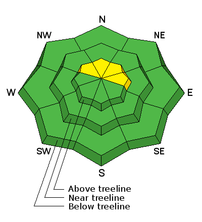
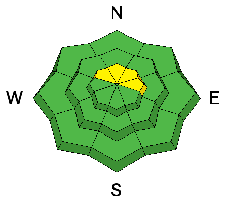
bottom line The avalanche danger is MODERATE where human triggered avalanches are possible in steep wind drifted terrain at or above tree line on the north half of the compass. Out of the wind effected terrain the avalanche danger is LOW.
|
 |
special announcement
|
 |
current conditions Expect a brisk start to the morning and partly cloudy skies, most mountain basins hovering in the single digits to low teens. Winds remain calm out of the northeast, with the highest peaks blowing in 15-20 mph range. However, this is a different story to what happened on Thursday afternoon where southwest winds were cranking 50-75 mph along the highest peaks. As the initial part of the storm passed the winds switched to the northwest and almost immediately died. A fresh coat of low density snow falling straight out of the sky fell Thursday night giving the northern Uintas a modest 3-5 inches of new snow in the higher elevations. Mirror Lake Highway area stayed unsettled for most the day on Friday, bringing the total new snow in the 6-8 inch range. Most of the lower elevations picked up only an inch or two. Depending on your location yesterday you either had sunny skies or a snowy winter wonderland. This past storm was a nice shot of snow for the Uintas. However, the fact is that it remains very thin out there. The best bet is sticking to the road or grassy meadows. Recent trip reports and observations are found here.
|
 |
recent activity While we didn't see or hear of any avalanche activity, we did get one report of collapsing/whooping reported yesterday on a wind loaded NE facing slope at 10,600ft in Upper Weber Canyon. Remember collapsing and whooping sounds are a big indicators of unstable snow. See or trigger an avalanche? Shooting cracks? Hear a collapse? It's simple. Go here to fill out an observation. |
| type | aspect/elevation | characteristics |
|---|

|
|
LIKELIHOOD
 LIKELY
UNLIKELY
SIZE
 LARGE
SMALL
TREND
 INCREASING DANGER
SAME
DECREASING DANGER
|
|
description
In our travels Friday to Upper Weber Canyon we were not seeing many wind slabs along the high terrain. Even though the winds ripped out of the southwest we were surprised to find mostly stable condition. But, the Uintas are a big place, If you find your-self in steep wind loaded terrain facing the north half of the compass look for and avoid rounded, pillowy, wind drifted snow. Remember that any avalanche triggered right now could be a season ender due to hitting rocks and stumps on the way down. Heads up - with a couple storms headed our way, expect a rising avalanche danger, especially early in the week starting late Sunday evening. Click here to view more Uinta observations and trip reports.
|
 |
weather A ridge builds in today giving cool partly cloudy skies, with high temperatures reaching the mid 20's. Winds should remain calm out of the northeast today with the highest peaks ranging in the 15-25 mph. Tonights temps will drop into the low single digits. Sunday the winds should pick up in the late afternoon ahead of what looks to be a good shot of snow for northern Utah late Sunday evening into Monday.
|
| general announcements Remember your information can save lives. If you see anything we should know about, please participate in the creation of our own community avalanche advisory by submitting snow and avalanche conditions. You can call me directly at 801-231-2170, email [email protected], or email by clicking HERE This is a great time of year to schedule a free avalanche awareness presentation for your group or club. You can contact me at 801-231-2170 or email [email protected]. To register for the first in our series of on-the-snow sled specific classes you can register here. The information in this advisory is from the US Forest Service which is solely responsible for its content. This advisory describes general avalanche conditions and local variations always occur. The information in this advisory expires 24 hours after the date and time posted, but be will be updated by 7:00 AM on Sunday, December 13th.
|


