| Please join us at the 23rd annual Black Diamond Fall Fundraiser Party Thursday Sept 15. Tickets are on sale now here, at the Black Diamond store & at REI. Special bonus raffle for online ticket purchasers! |
| Please join us at the 23rd annual Black Diamond Fall Fundraiser Party Thursday Sept 15. Tickets are on sale now here, at the Black Diamond store & at REI. Special bonus raffle for online ticket purchasers! |
| Advisory: Uintas Area Mountains | Issued by Craig Gordon for Sunday - December 6, 2015 - 3:21am |
|---|

|
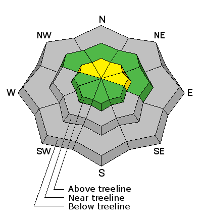
bottom line In general most terrain throughout the range offers a LOW avalanche danger. However, in the wind zone at and above treeline, the avalanche danger is MODERATE. While not widespread, human triggered avalanches are possible, on steep, wind drifted slopes facing the north half of the compass.
|
 |
current conditions The first in a series of weak storms is moving into the region and as such, south winds increased into the 20's and 30's along the high peaks overnight. In addition, temperatures have risen into the upper 20's along the ridges, but remain a bit inverted at lower elevations, still hovering in the mid teens. Click here for real time snow, winds, and temperatures.
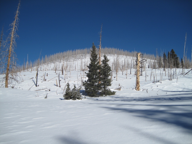
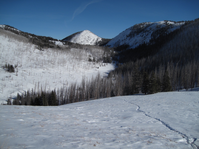
Yikes... the Uinta's are kinda thin and the snowpack is losing structure and supportability. Best bet is sticking to road rides or low angle grassy meadows. If there's a lump in the snow, chances are there's a sled wrecking rock hidden underneath. Recent trip reports and observations are found here.
|
 |
recent activity
No new avalanche activity to report, but Ted was able to collapse this slope, resulting in a low, rumbling whoomph and a long, shooting crack. More on his travels to Millcreek are found here. See or trigger an avalanche? Shooting cracks? Hear a collapse? It's simple. Go here to fill out an observation. |
| type | aspect/elevation | characteristics |
|---|

|
|
LIKELIHOOD
 LIKELY
UNLIKELY
SIZE
 LARGE
SMALL
TREND
 INCREASING DANGER
SAME
DECREASING DANGER
|
|
description
Midweek winds worked the upper elevation terrain, finding enough loose snow to blow around and form drifts on steep leeward terrain and around terrain features like chutes or gullies. Ted was out yesterday on the east side of the range in Millcreek and found consistently, inconsistent conditions. Some areas the snowpack was supportable... and then just a few feet away you drop into a sand box. In addition, where strong snow rests on weak sugary snow, Ted experienced a few collapses and shooting cracks. While not overly sensitive to our additional weight, if your travels take you into upper elevation terrain facing the north half of the compass, I'd look for and avoid any fat, rounded piece of snow, especially if it sounds hollow like a drum. Remember- even a shallow slide can take you for a nasty ride through rocks and stumps barely hidden under our shallow snowpack.
Wind textured snow in open terrain can give you a clue that the winds have been busy at work. Click here to view more Uinta observations and trip reports.
|
 |
weather Clouds stream into the region this morning, bringing with them a flurry or two along with rather mild temperatures. Highs climb into the upper 30's and it'll be breezy along the ridges with southerly winds blowing in the 30's and 40's. A weak cold front slides through late in the day and overnight temperatures dip into the single digits. This pattern continues throughout the week with computer models suggesting a stronger system late in the week.
|
| general announcements Remember your information can save lives. If you see anything we should know about, please participate in the creation of our own community avalanche advisory by submitting snow and avalanche conditions. You can call me directly at 801-231-2170, email [email protected], or email by clicking HERE This is a great time of year to schedule a free avalanche awareness presentation for your group or club. You can contact me at 801-231-2170 or email [email protected]. To register for the first in our series of on-the-snow sled specific classes you can register here. The information in this advisory is from the US Forest Service which is solely responsible for its content. This advisory describes general avalanche conditions and local variations always occur. The information in this advisory expires 24 hours after the date and time posted, but be will be updated by 7:00 AM on Wednesday, December 9th.
|