| Please join us at the 23rd annual Black Diamond Fall Fundraiser Party Thursday Sept 15. Tickets are on sale now here, at the Black Diamond store & at REI. Special bonus raffle for online ticket purchasers! |
| Please join us at the 23rd annual Black Diamond Fall Fundraiser Party Thursday Sept 15. Tickets are on sale now here, at the Black Diamond store & at REI. Special bonus raffle for online ticket purchasers! |
| Advisory: Uintas Area Mountains | Issued by Craig Gordon for Saturday - December 5, 2015 - 5:19am |
|---|

|
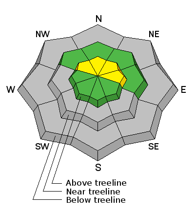
bottom line In general most terrain throughout the range offers a LOW avalanche danger. However, in the wind zone at and above treeline, the avalanche danger is MODERATE. While not widespread, human triggered avalanches are possible, on steep, wind drifted slopes facing the north half of the compass.
|
 |
current conditions Skies are partly cloudy and temperatures about 10-15 degrees cooler than yesterday at this time, right now hovering in the single digits and low teens. Along the ridges winds finally relaxed, switched to the west and northwest and they're blowing 10-20 mph along the high peaks. Looks like we might've squeaked a trace or possibly a couple traces of snow out of yesterday's cold front, but the sad state of affairs is the Uinta's are boney and in general you gotta stick to road rides or low angle grassy meadows. If there's a lump in the snow, chances are there's a sled wrecking rock hidden underneath... go gently. Our western Uinta weather station network is up and running. Click here for real time snow, winds, and temperatures. Recent trip reports and observations are found here.
|
 |
recent activity No new avalanche activity to report. See or trigger an avalanche? Shooting cracks? Hear a collapse? It's simple. Go here to fill out an observation. |
| type | aspect/elevation | characteristics |
|---|

|
|
LIKELIHOOD
 LIKELY
UNLIKELY
SIZE
 LARGE
SMALL
TREND
 INCREASING DANGER
SAME
DECREASING DANGER
|
|
description
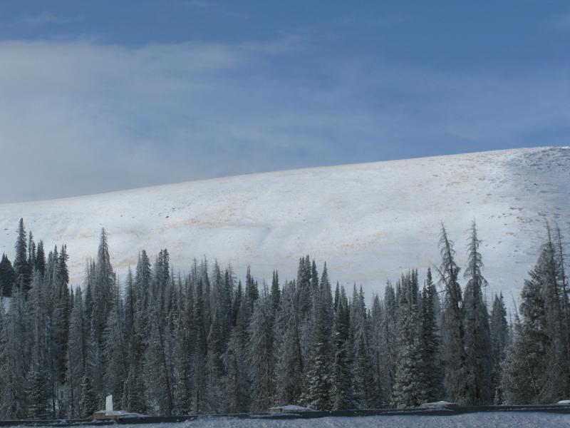
Southwest winds ramped up on Thursday, blowing in the 30's and 40's for nearly 24 hours. If it were the middle of winter and we had plenty of snow to blow around the avy danger would be off the hook. Instead, much of our south facing terrain is bare and brushy and there's little snow available for transport. The flip side to this is... it never ceases to amaze me how wind can find a little bit of snow and form slabs that break deeper and wider than we might expect. While not overly sensitive to our additional weight, if your travels take you into upper elevation terrain facing the north half of the compass, I'd look for and avoid any fat, rounded piece of snow, especially if it sounds hollow like a drum. Remember- even a shallow slide can take you for a nasty ride through rocks and stumps barely hidden under our shallow snowpack.
Even though winds were strong, there's still lots of bushes poking out and not much snow available for transport.
Click here to view more Uinta observations and trip reports.
|
 |
weather Look for partly cloudy skies, northwest winds in the 10-20 mph range along the ridges, and high temperatures climbing into the upper 20's and low 30's. Overnight lows dip into the teens. Southwest winds increase late Sunday as another weak system grazes northern Utah. Looking into the weather crystal ball, we should see a series of systems throughout the week which help to create a change in the pattern around Thursday. Details are still a bit hazy, but there appears to be a glimmer of hope that winter returns from its hiatus late in the work week.
|
| general announcements Remember your information can save lives. If you see anything we should know about, please participate in the creation of our own community avalanche advisory by submitting snow and avalanche conditions. You can call me directly at 801-231-2170, email [email protected], or email by clicking HERE This is a great time of year to schedule a free avalanche awareness presentation for your group or club. You can contact me at 801-231-2170 or email [email protected]. To register for the first in our series of on-the-snow sled specific classes you can register here. The information in this advisory is from the US Forest Service which is solely responsible for its content. This advisory describes general avalanche conditions and local variations always occur. The information in this advisory expires 24 hours after the date and time posted, but be will be updated by 7:00 AM on Sunday, December 6th.
|