
| During the month of April, Mark Miller will donate $75 to the charity of your choice (5 to chose from, including the Utah Avalanche Center!) Mark Miller Subaru has raised over $300k in the previous 6 Do Good Feel Good events. More Info here |  |
| During the month of April, Mark Miller will donate $75 to the charity of your choice (5 to chose from, including the Utah Avalanche Center!) Mark Miller Subaru has raised over $300k in the previous 6 Do Good Feel Good events. More Info here | |
| Advisory: Uintas Area Mountains | Issued by Craig Gordon for Wednesday - March 18, 2015 - 5:40am |
|---|

|
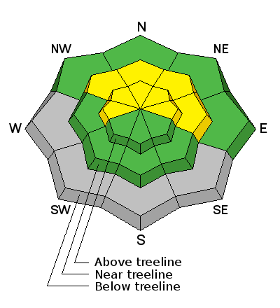
bottom line The avalanche danger will rise to MODERATE and human triggered slides are possible on steep slopes facing the north half of the compass, especially during the heat of the day. Avalanches triggered in steep, rocky terrain have the potential to break deeper and wider than you might expect. Most other terrain offers a LOW avalanche danger.
|
 |
current conditions A cold front slipped through the region while we were sleeping, helping to knock temperatures into the low 30's. Skies are clearing and northwesterly winds are blowing 15-20 mph along the high ridges. Snow surface conditions are hit or miss and there's not much soft snow to be had. Yep... it's rough going out there, especially in the morning. Might be a good call to let things soften a bit before battling the frozen old tracks. Click here for real-time temperatures, snowfall, and winds.
|
 |
recent activity No recent avalanche activity to report
|
| type | aspect/elevation | characteristics |
|---|

|

|
LIKELIHOOD
 LIKELY
UNLIKELY
SIZE
 LARGE
SMALL
TREND
 INCREASING DANGER
SAME
DECREASING DANGER
|
|
description
Cooler temperatures, northerly winds, and partly cloudy skies will help to temper the wet avalanche activity today. On most slopes the avalanche danger is pretty straight-forward, though I'm not thoroughly convinced we're out of the woods, especially in steep, rocky terrain facing the north half of the compass. On steep slopes that have had a thin, weak snowpack all season, it's possible to trigger a shallow wet sluff that then breaks into weak snow as it descends the slope. Not a big issue unless you're in steep, unforgiving terrain or where the avalanche debris gets channeled into a terrain trap like a gully or road cut. Best rule of thumb is- if you feel the snow getting damp or punchy, simply move to a cooler aspect, get off of and out from steep, sunny slopes, or just call it a day.
|
 |
weather It'll be partly cloudy with temperatures only rising into the low 40's. Northerly winds blow in the 20's along the high peaks and under mostly clear skies, overnight lows dip into the mid 20's. High pressure is on tap for the latter half of the week, with another dry, cold front moving through the region over the weekend.
|
| general announcements Remember your information can save lives. If you see anything we should know about, please participate in the creation of our own community avalanche advisory by submitting snow and avalanche conditions. You can call me directly at 801-231-2170, email [email protected], or email by clicking HERE This is a great time of year to schedule a free avalanche awareness presentation for your group or club. You can contact me at 801-231-2170 or email [email protected] Donate to your favorite non-profit –The Utah Avalanche Center. The UAC depends on contributions from users like you to support our work. Benefit the Utah Avalanche Center when you buy or sell on ebay - set the Utah Avalanche Center as a favorite non-profit in your ebay account here and click on ebay gives when you buy or sell. You can choose to have your seller fees donated to the UAC, which doesn't cost you a penny. Utah Avalanche Center mobile app - Get your advisory on your iPhone along with great navigation and rescue tools. The information in this advisory is from the US Forest Service which is solely responsible for its content. This advisory describes general avalanche conditions and local variations always occur. I will update this advisory by 7:00 AM Saturday Mar. 21, 2015. |


_0.jpg)
