| During the month of April, Mark Miller will donate $75 to the charity of your choice (5 to chose from, including the Utah Avalanche Center!) Mark Miller Subaru has raised over $300k in the previous 6 Do Good Feel Good events. More Info here |  |
| During the month of April, Mark Miller will donate $75 to the charity of your choice (5 to chose from, including the Utah Avalanche Center!) Mark Miller Subaru has raised over $300k in the previous 6 Do Good Feel Good events. More Info here | |
| Advisory: Uintas Area Mountains | Issued by Craig Gordon for Sunday - March 1, 2015 - 5:33am |
|---|

|
bottom line Pockets of MODERATE avalanche danger exist along the leeward side of the highest ridges, especially on slopes facing the north half of the compass and particularly those slopes with a hint of west to their aspect. While not widespread, human triggered avalanches are possible in terrain with these characteristics. Most other terrain offers a LOW avalanche danger.
|
 |
special announcement RESEARCH PROJECT ON UNDERSTANDING TRAVEL BEHAVIOR IN AVALANCHE TERRAIN NEEDS YOU! Scientists from the Snow and Avalanche Lab at Montana State University are seeking more participants for their project examining decision making and travel in avalanche terrain. Their project aims to collect GPS location information (from your smartphone) and survey responses from backcountry skiers and riders to better understand what types of terrain are used and how decisions are made. Their focus is on backcountry skiers and riders of all abilities and experience. For more information: www.montana.edu/snowscience/tracks For snowmobilers: www.montana.edu/snowscience/sleds We just released an exciting, new avy safety video designed specifically for snowmobilers - Knowledge is Powder. https://vimeo.com/113677686 NEW THIS YEAR: You can now receive advisories by email for each region in the state. Go here for details. |
 |
current conditions Scattered snow showers continued overnight, stacking up and additional 3" at most locations... the southern half of the range got a little more love with just over 5" near Currant Creek and around Daniels/Strawberry. Winds are light and southerly, blowing just 10-20 mph along the high ridges and temperatures are in the mid teens. These little impulses of snow are stacking up with just over a foot of snow since midweek. The riding and turning conditions are about as good as they get. Click here for real-time temperatures, snowfall, and winds.
|
 |
recent activity
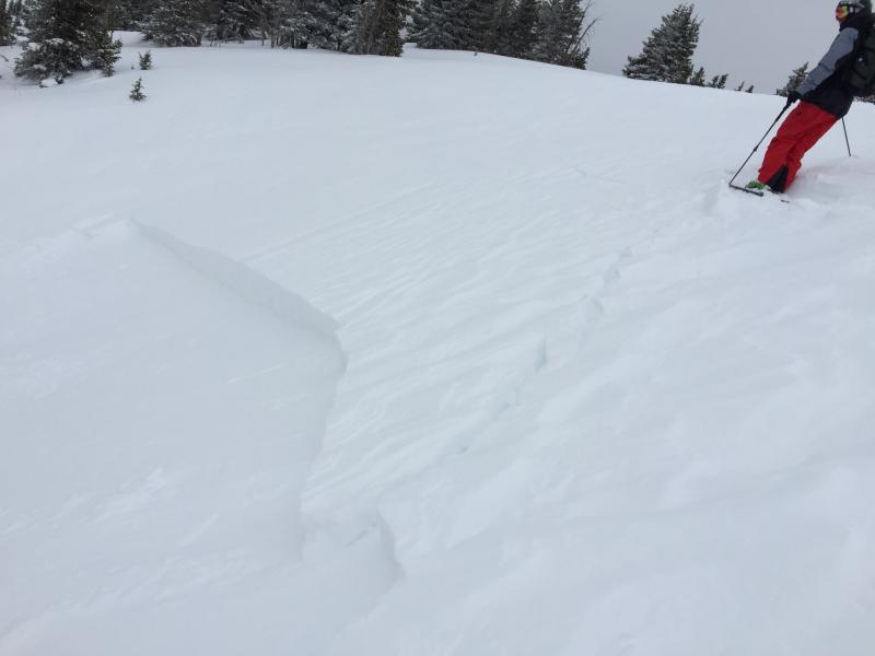
Not particularly deep, but this slide could've worked ya when all was said and done. Unintentionally triggered yesterday on a steep, upper elevation Northwest facing slope of Moffit Peak, this pocket was about 15" deep, 70' wide, and was packing a punch as it ran 700' vertically, dusting the flats below. Trent posted his take on snow conditions which can be found here.
|
| type | aspect/elevation | characteristics |
|---|

|
|
LIKELIHOOD
 LIKELY
UNLIKELY
SIZE
 LARGE
SMALL
TREND
 INCREASING DANGER
SAME
DECREASING DANGER
|
|
description
East and southeast winds ramped up yesterday morning, gusting into the 20's and 30's along the high peaks. With plenty of snow to blow around, the landscape quickly changed and shallow soft slabs formed around terrain features on the leeward side of upper elevation ridges. I don't think these drifts are gonna be as sensitive as they were yesterday, but you'll definitely wanna be on your toes as you change aspect or elevation throughout the day. Remember- shooting cracks are a big clue to unstable snow and you'll definitely want to avoid any fat, rounded pillows of snow. Lose a little elevation and you lose the problem.
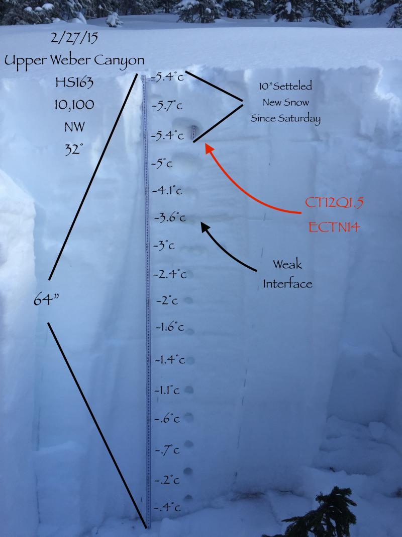
Bomber snow structure... explains why avalanches are only failing within the new storm snow. Thanks to JG for this awesome pit data, clearly illustrating our current snowpack setup.
|
 |
weather A break in the action this morning as the next in a series of storms sets its sights on the region. Winds should remain light and variable and temperatures climb into the upper 20's. Southwest winds increase overnight and scattered snow showers develop late in the day. A couple inches should stack up on Monday with much colder temperatures and southwest winds gusting into the 30's. Snowfall begins in earnest late Monday, lasting through Tuesday and a foot of new snow is a good bet before high pressure builds for Wednesday through the end of the week.
|
| general announcements Remember your information can save lives. If you see anything we should know about, please participate in the creation of our own community avalanche advisory by submitting snow and avalanche conditions. You can call me directly at 801-231-2170, email [email protected], or email by clicking HERE This is a great time of year to schedule a free avalanche awareness presentation for your group or club. You can contact me at 801-231-2170 or email [email protected] Donate to your favorite non-profit –The Utah Avalanche Center. The UAC depends on contributions from users like you to support our work. Benefit the Utah Avalanche Center when you buy or sell on ebay - set the Utah Avalanche Center as a favorite non-profit in your ebay account here and click on ebay gives when you buy or sell. You can choose to have your seller fees donated to the UAC, which doesn't cost you a penny. Utah Avalanche Center mobile app - Get your advisory on your iPhone along with great navigation and rescue tools. The information in this advisory is from the US Forest Service which is solely responsible for its content. This advisory describes general avalanche conditions and local variations always occur. I will update this advisory by 7:00 AM Wednesday Mar. 4, 2015. |


_0.jpg)