
| During the month of April, Mark Miller will donate $75 to the charity of your choice (5 to chose from, including the Utah Avalanche Center!) Mark Miller Subaru has raised over $300k in the previous 6 Do Good Feel Good events. More Info here |  |
| During the month of April, Mark Miller will donate $75 to the charity of your choice (5 to chose from, including the Utah Avalanche Center!) Mark Miller Subaru has raised over $300k in the previous 6 Do Good Feel Good events. More Info here | |
| Advisory: Uintas Area Mountains | Issued by Craig Gordon for Saturday - February 7, 2015 - 5:09am |
|---|


|
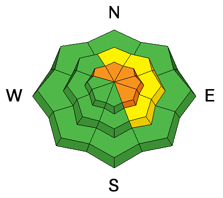
bottom line In the wind zone at and above treeline, pockets of CONSIDERABLE avalanche danger exist and human triggered avalanches are probable, especially on steep slopes facing the north half of the compass. While not as widespread, winds are getting into mid elevation terrain where a MODERATE avalanche danger exists. Human triggered avalanches are possible on steep wind drifted slopes Out of the wind the avalanche danger is generally LOW.
|
 |
special announcement We've got open slots for next weekends Avy and Riding Skills Workshop. More info can be found here And a great recap of the workshop is found here. RESEARCH PROJECT ON UNDERSTANDING TRAVEL BEHAVIOR IN AVALANCHE TERRAIN NEEDS YOU! Scientists from the Snow and Avalanche Lab at Montana State University are seeking more participants for their project examining decision making and travel in avalanche terrain. Their project aims to collect GPS location information (from your smartphone) and survey responses from backcountry skiers and riders to better understand what types of terrain are used and how decisions are made. Their focus is on backcountry skiers and riders of all abilities and experience. For more information: www.montana.edu/snowscience/tracks For snowmobilers: www.montana.edu/snowscience/sleds We just released an exciting, new avy safety video designed specifically for snowmobilers - Knowledge is Powder. https://vimeo.com/113677686 NEW THIS YEAR: You can now receive advisories by email for each region in the state. Go here for details. |
 |
current conditions A weak system to our north continues to produce cow tipping southwest winds in the 50's and 60's... though no bovines were injured in the making of this storm. Thick clouds over the region kept temperatures ridiculously warm overnight and we're currently in the low to mid 30's. Strong winds have smoked the big, open bowls, but hunt around a little and you'll be rewarded with dense, creamy snow in wind sheltered shady terrain. Click here for real-time temperatures, snowfall, and winds.
|
 |
recent activity
Not particularly deep, but slabs are becoming more connected and could definitely ruin your day if you were on the receiving end.
|
| type | aspect/elevation | characteristics |
|---|

|
|
LIKELIHOOD
 LIKELY
UNLIKELY
SIZE
 LARGE
SMALL
TREND
 INCREASING DANGER
SAME
DECREASING DANGER
|
|
description
Winds have been nuking along the high ridges for the past few days and there's no shortage of snow to blow around and form drifts sensitive to the weight of a rider. It's not all that cut and dry though, as the combination of dense storm snow and erratic winds are creating an uneven distribution of snow. What this means is the connectivity of the slabs can change in a matter of a hundred feet. One moment you're on a icy, wind scoured patch of snow.... the next, in a thick, dense wind drift. So you'll want to carefully analyze your terrain choices, especially if your travels take you into multiple drainages and elevations. I suspect today's drifts are gonna break deeper and wider than you might expect and they'll be packing a punch. While mostly confined to steep, upper elevation terrain facing the north half of the compass, you'll want to look for and avoid any fat looking, rounded piece of snow, especially if it sounds hollow like a drum.
Recent avalanche activity in Whitney Basin. Not widespread, but definitely large enough to roll you.
|
| type | aspect/elevation | characteristics |
|---|

|

|
LIKELIHOOD
LIKELY
UNLIKELY
SIZE
LARGE
SMALL
TREND
INCREASING DANGER
SAME
DECREASING DANGER
|
|
description
Cornices have grown large and are breaking back a bit further than you might expect. In addition, there's a chance that once initiated, a large block of corni can trigger a slab as it crashed on the slope below.
|
 |
weather A weakening system crosses northern Utah today with scattered rain and snow showers expected. Winds should start to mellow out this afternoon as this wave passes. Temperatures climb into the low 40's today with overnight lows in the upper 20's. Another weak system slides through the region late tonight into early Sunday with a few more snow showers possible, then clearing for midday through early in the week. Something a little more promising might be headed our way late Monday with a good shot of snow. Stay tuned... I'll have a better handle on that system for tomorrow's advisory.
|
| general announcements Remember your information can save lives. If you see anything we should know about, please participate in the creation of our own community avalanche advisory by submitting snow and avalanche conditions. You can call me directly at 801-231-2170, email [email protected], or email by clicking HERE This is a great time of year to schedule a free avalanche awareness presentation for your group or club. You can contact me at 801-231-2170 or email [email protected] Donate to your favorite non-profit –The Utah Avalanche Center. The UAC depends on contributions from users like you to support our work. Benefit the Utah Avalanche Center when you buy or sell on ebay - set the Utah Avalanche Center as a favorite non-profit in your ebay account here and click on ebay gives when you buy or sell. You can choose to have your seller fees donated to the UAC, which doesn't cost you a penny. Utah Avalanche Center mobile app - Get your advisory on your iPhone along with great navigation and rescue tools. The information in this advisory is from the US Forest Service which is solely responsible for its content. This advisory describes general avalanche conditions and local variations always occur. I will update this advisory by 7:00 AM Sunday Feb. 8, 2015. |


_0.jpg)


