| During the month of April, Mark Miller will donate $75 to the charity of your choice (5 to chose from, including the Utah Avalanche Center!) Mark Miller Subaru has raised over $300k in the previous 6 Do Good Feel Good events. More Info here |  |
| During the month of April, Mark Miller will donate $75 to the charity of your choice (5 to chose from, including the Utah Avalanche Center!) Mark Miller Subaru has raised over $300k in the previous 6 Do Good Feel Good events. More Info here | |
| Advisory: Uintas Area Mountains | Issued by Craig Gordon for Wednesday - February 4, 2015 - 5:54am |
|---|


|
bottom line In the wind zone at and above treeline, a MODERATE avalanche exists and human triggered avalanches are possible on steep wind drifted terrain, especially slopes with an easterly component to its aspect. Out of the wind the avalanche danger is generally LOW.
|
 |
special announcement We've got open slots for next weekends Avy and Riding Skills Workshop. More info can be found here And a great recap of the workshop is found here. RESEARCH PROJECT ON UNDERSTANDING TRAVEL BEHAVIOR IN AVALANCHE TERRAIN NEEDS YOU! Scientists from the Snow and Avalanche Lab at Montana State University are seeking more participants for their project examining decision making and travel in avalanche terrain. Their project aims to collect GPS location information (from your smartphone) and survey responses from backcountry skiers and riders to better understand what types of terrain are used and how decisions are made. Their focus is on backcountry skiers and riders of all abilities and experience. For more information: www.montana.edu/snowscience/tracks For snowmobilers: www.montana.edu/snowscience/sleds We just released an exciting, new avy safety video designed specifically for snowmobilers - Knowledge is Powder. https://vimeo.com/113677686 NEW THIS YEAR: You can now receive advisories by email for each region in the state. Go here for details. |
 |
current conditions A nice shot of snow rolled over the North Slope overnight, delivering 4" of dense, spongy snow. Snow totals are about half that amount south of Trial Lake. West and southwest winds increased along the high ridges late Tuesday afternoon, with hourly averages in the 30's and 40's, gusting in the 50's on the most exposed peaks. Temperatures are insanely warm for February. Currently, it's barely freezing along the ridges and in the mid 30's at the trailheads. It's not over the hood, but dense, surfy snow has vastly improved the riding and turning conditions Click here for real-time temperatures, snowfall, and winds.
|
 |
recent activity
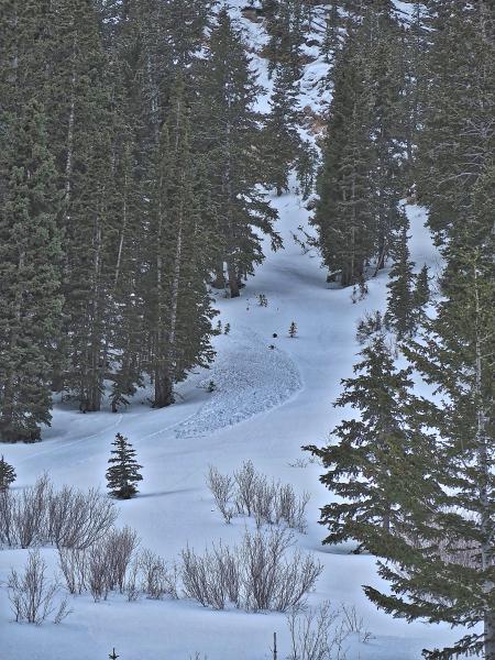
JG noticed this sluff peeling off of a steep cliff band in Weber Canyon. More on his travels can be found here.
|
| type | aspect/elevation | characteristics |
|---|

|
|
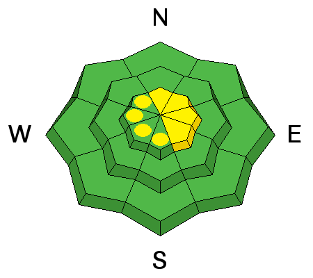
LIKELIHOOD
 LIKELY
UNLIKELY
SIZE
 LARGE
SMALL
TREND
 INCREASING DANGER
SAME
DECREASING DANGER
|
|
description
While we've been nickled and dimed the past few days with an inch here and there, but new snow totals are actually starting to stack up. Since Sunday night, the North Slope has been the benefactor with about 8" of snow and nearly an inch of water. Yesterday, shallow soft slabs up to a foot deep were sensitive to the additional weight of a rider, but with additional wind and snow overnight, I suspect today's drifts are gonna break deeper and wider than you might expect. In addition, they're sliding on some slick heat crusts, so they'll be packing a punch. While mostly confined to steep, upper elevation terrain, especially slopes with an easterly component to it's aspect, today, you'll want to look for and avoid any fat looking, rounded piece of snow, especially if it sounds hollow like a drum.
|
 |
weather A moist system makes its way through northern Utah this morning, with a couple of additional inches of snow expected. West and northwest winds are gonna be a nuisance, gusting into the 30's and 40's along the high ridges. Temperatures rise into the upper 30's and dip into the mid 20's overnight. Strong, high pressure builds for Thursday and Friday with record setting temperatures soaring into the mid 40's Thursday.... low to mid 50's Friday. A brushby on Saturday night gives us a dusting of snow with a better looking shot of snow developing Monday night/Tuesday.
|
| general announcements Remember your information can save lives. If you see anything we should know about, please participate in the creation of our own community avalanche advisory by submitting snow and avalanche conditions. You can call me directly at 801-231-2170, email [email protected], or email by clicking HERE This is a great time of year to schedule a free avalanche awareness presentation for your group or club. You can contact me at 801-231-2170 or email [email protected] Donate to your favorite non-profit –The Utah Avalanche Center. The UAC depends on contributions from users like you to support our work. Benefit the Utah Avalanche Center when you buy or sell on ebay - set the Utah Avalanche Center as a favorite non-profit in your ebay account here and click on ebay gives when you buy or sell. You can choose to have your seller fees donated to the UAC, which doesn't cost you a penny. Utah Avalanche Center mobile app - Get your advisory on your iPhone along with great navigation and rescue tools. The information in this advisory is from the US Forest Service which is solely responsible for its content. This advisory describes general avalanche conditions and local variations always occur. I will update this advisory by 7:00 AM Saturday Feb. 7, 2015. |


_0.jpg)