| During the month of April, Mark Miller will donate $75 to the charity of your choice (5 to chose from, including the Utah Avalanche Center!) Mark Miller Subaru has raised over $300k in the previous 6 Do Good Feel Good events. More Info here |  |
| During the month of April, Mark Miller will donate $75 to the charity of your choice (5 to chose from, including the Utah Avalanche Center!) Mark Miller Subaru has raised over $300k in the previous 6 Do Good Feel Good events. More Info here | |
| Advisory: Uintas Area Mountains | Issued by Craig Gordon for Saturday - January 17, 2015 - 5:30am |
|---|

|
bottom line At upper elevations in the wind zone a MODERATE avalanche danger exists and human triggered avalanches are possible on steep slopes with recent deposits of wind drifted snow. While not widespread and making up a small portion of the terrain available to ride in, once triggered, avalanches still have potential to break to weak layers near the ground, especially on slopes facing North, Northeast, and East. All other terrain offers a LOW avalanche danger.
|
 |
special announcement We just released an exciting, new avy safety video designed specifically for snowmobilers - Knowledge is Powder. https://vimeo.com/113677686 NEW THIS YEAR: You can now receive advisories by email for each region in the state. Go here for details. |
 |
current conditions A weak storm slid through the region last night, depositing an inch of snow and knocking temperatures back into the teens. Yesterday's annoying southwest winds blew in the 40's and 50's along the high ridges and switched to the west and northwest around 10:00 last night, decreasing into the 20's and 30's. Wind and warm temperatures have had their way with the surface snow, but hunt around a little and you'll still find soft, creamy snow, on wind sheltered, shady slopes. Click here for real-time temperatures, snowfall, and winds.
|
 |
recent activity
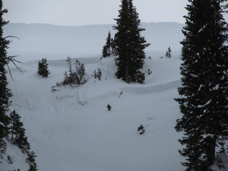
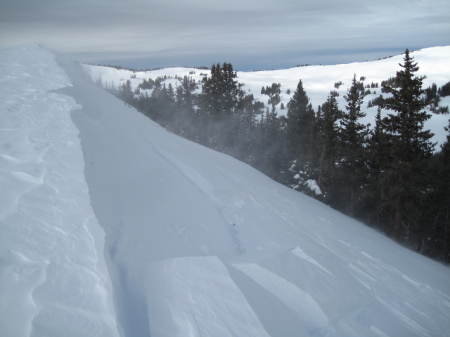
This midslope avalanche in the Superbowl was triggered Wednesday from a nearby ridgeline hundreds of feet away and broke to weak snow near the ground. |
| type | aspect/elevation | characteristics |
|---|

|
|
LIKELIHOOD
 LIKELY
UNLIKELY
SIZE
 LARGE
SMALL
TREND
 INCREASING DANGER
SAME
DECREASING DANGER
|
|
description
Winds have been all over the place and the most obvious avalanche dragon today are fresh drifts along the leeward side of upper elevation ridges. While mostly manageable in size and depth, if you're in steep, committing terrain, even a small slide can knock you off your feet or roll your machine and at the very least, be an instant buzz-kill.
|
| type | aspect/elevation | characteristics |
|---|

|

|
LIKELIHOOD
 LIKELY
UNLIKELY
SIZE
 LARGE
SMALL
TREND
INCREASING DANGER
SAME
DECREASING DANGER
|
|
description
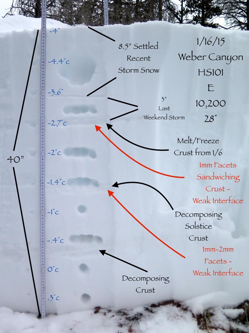
The storm snow from earlier this week is settling, gaining more strength, and in turn, becoming more of a slab. While the surface snow will feel pretty bomber underneath our skis, board, or sled, but I'm not totally convinced our midpack weakness is super comfortable in it's own skin just yet. While it's more the exception than the rule, you can still trigger a slide that breaks to weak snow near the ground. Prime suspects are slopes facing North, Northeast, and East at upper elevations and terrain that avalanched during the Solstice storm. The recent slide in Superbowl perfectly illustrates the setup and JG's brilliant pit profile below clearly shows the midpack weakness.
|
 |
weather High pressure builds over the region and we'll see partly cloudy skies, temperatures warming into the mid 30's, and northwest winds blowing in the 30's along the high ridges. Overnight lows dip into the mid 20's, winds switch to the west-southwest, and we might see a flurry or two tonight as another weak system slides through the region. A series of weak storms are scheduled to clip the state throughout the week, but there are no big storms in sight. |
| general announcements Remember your information can save lives. If you see anything we should know about, please participate in the creation of our own community avalanche advisory by submitting snow and avalanche conditions. You can call me directly at 801-231-2170, email [email protected], or email by clicking HERE This is a great time of year to schedule a free avalanche awareness presentation for your group or club. You can contact me at 801-231-2170 or email [email protected] Donate to your favorite non-profit –The Utah Avalanche Center. The UAC depends on contributions from users like you to support our work. Benefit the Utah Avalanche Center when you buy or sell on ebay - set the Utah Avalanche Center as a favorite non-profit in your ebay account here and click on ebay gives when you buy or sell. You can choose to have your seller fees donated to the UAC, which doesn't cost you a penny. Utah Avalanche Center mobile app - Get your advisory on your iPhone along with great navigation and rescue tools. The information in this advisory is from the US Forest Service which is solely responsible for its content. This advisory describes general avalanche conditions and local variations always occur. I will update this advisory by 7:00 AM Sunday Jan. 18, 2015. |


_0.jpg)